
-
Federal
Bathymetry of Lake Superior
National Oceanic and Atmospheric Administration, Department of Commerce —
Bathymetry of Lake Superior has been compiled as a component of a NOAA project to rescue Great Lakes lake floor geological and geophysical data and make it more... -
Federal
ETOPO 2022 15 Arc-Second Global Relief Model
National Oceanic and Atmospheric Administration, Department of Commerce —
ETOPO 2022, a global relief model with 15 arc-second resolution seamlessly integrating topographic and bathymetric data. The ETOPO 2022 model uses a combination of... -
Federal
Coastal Digital Elevation Models (DEMs)
National Oceanic and Atmospheric Administration, Department of Commerce —
Digital elevation models (DEMs) of U.S. and other coasts that typically integrate ocean bathymetry and land topography. The DEMs support NOAA's mission to understand... -
Federal
Multibeam collection for KN173L01: Multibeam data collected aboard Knorr from 22-Sep-03 to 20-Oct-03, Woods Hole, Massachusetts to Port of Spain, Trinidad and Tobago
National Oceanic and Atmospheric Administration, Department of Commerce —
This data set is part of a larger set of data called the Multibeam Bathymetry Database (MBBDB) where other similar data can be found -
Federal
F00909: NOS Hydrographic Survey , 2024-09-30
National Oceanic and Atmospheric Administration, Department of Commerce —
The National Oceanic and Atmospheric Administration (NOAA) has the statutory mandate to collect hydrographic data in support of nautical chart compilation for safe... -
Federal
Multibeam collection for KN152L1: Multibeam data collected aboard Knorr from 16-Sep-97 to 16-Sep-97, Woods Hole, Massachusetts to Woods Hole, Massachusetts
National Oceanic and Atmospheric Administration, Department of Commerce —
This data set is part of a larger set of data called the Multibeam Bathymetry Database (MBBDB) where other similar data can be found -
Federal
Multibeam Bathymetry Database (MBBDB) NGDA
National Oceanic and Atmospheric Administration, Department of Commerce —
Originally designed for military use, the multibeam echosounder has proved very useful for nautical charting, oceanographic research and modeling, habitat... -
Federal
ETOPO1 1 Arc-Minute Global Relief Model
National Oceanic and Atmospheric Administration, Department of Commerce —
In August 2008, the National Geophysical Data Center (NGDC), an office of the National Oceanic and Atmospheric Administration (NOAA), developed the ETOPO1 Global... -
Federal
H13803: NOS Hydrographic Survey , 2023-06-01
National Oceanic and Atmospheric Administration, Department of Commerce —
The National Oceanic and Atmospheric Administration (NOAA) has the statutory mandate to collect hydrographic data in support of nautical chart compilation for safe... -
Federal
U.S. Coastal Relief Model Vol.3 - Florida and East Gulf of Mexico
National Oceanic and Atmospheric Administration, Department of Commerce —
NGDC's U.S. Coastal Relief Model (CRM) provides the first comprehensive view of the U.S. coastal zone integrating offshore bathymetry with land topography into a... -
Federal
U.S. Virgin Islands Coastal Digital Elevation Model
National Oceanic and Atmospheric Administration, Department of Commerce —
NOAA's National Geophysical Data Center (NGDC) is building high-resolution digital elevation models (DEMs) for select U.S. coastal regions. These integrated... -
Federal
L01081: NOS Hydrographic Survey , 1903-12-31
National Oceanic and Atmospheric Administration, Department of Commerce —
The National Oceanic and Atmospheric Administration (NOAA) has the statutory mandate to collect hydrographic data in support of nautical chart compilation for safe... -
Federal
L01100: NOS Hydrographic Survey , 1905-12-31
National Oceanic and Atmospheric Administration, Department of Commerce —
The National Oceanic and Atmospheric Administration (NOAA) has the statutory mandate to collect hydrographic data in support of nautical chart compilation for safe... -
Federal
Multibeam collection for MV1305: Multibeam data collected aboard Melville from 21-Mar-13 to 05-May-13, Yokohama, Japan to Honolulu, Hawaii
National Oceanic and Atmospheric Administration, Department of Commerce —
This data set is part of a larger set of data called the Multibeam Bathymetry Database (MBBDB) where other similar data can be found -
Federal
Coastal Relief Models (CRMs)
National Oceanic and Atmospheric Administration, Department of Commerce —
Coastal Relief Models CRMs provide seamless topographic and bathymetric bare-earth elevation profiles of coastal regions for US states and territories. Extents span... -
Federal
Port Lions, Alaska 8/15 arc-second MHHW Coastal Digital Elevation Model
National Oceanic and Atmospheric Administration, Department of Commerce —
NOAA's National Centers for Environmental Information is building high-resolution digital elevation models (DEMs) to support individual coastal States as part of the... -
Federal
2-minute Gridded Global Relief Data (ETOPO2) v2
National Oceanic and Atmospheric Administration, Department of Commerce —
This version has been superseded by a newer version. It is highly recommended for users to access the current version. Users should only access this superseded... -
Federal
F00473D: NOS Hydrographic Survey , San Diego Bay, California, 2001-04-13
National Oceanic and Atmospheric Administration, Department of Commerce —
The National Oceanic and Atmospheric Administration (NOAA) has the statutory mandate to collect hydrographic data in support of nautical chart compilation for safe... -
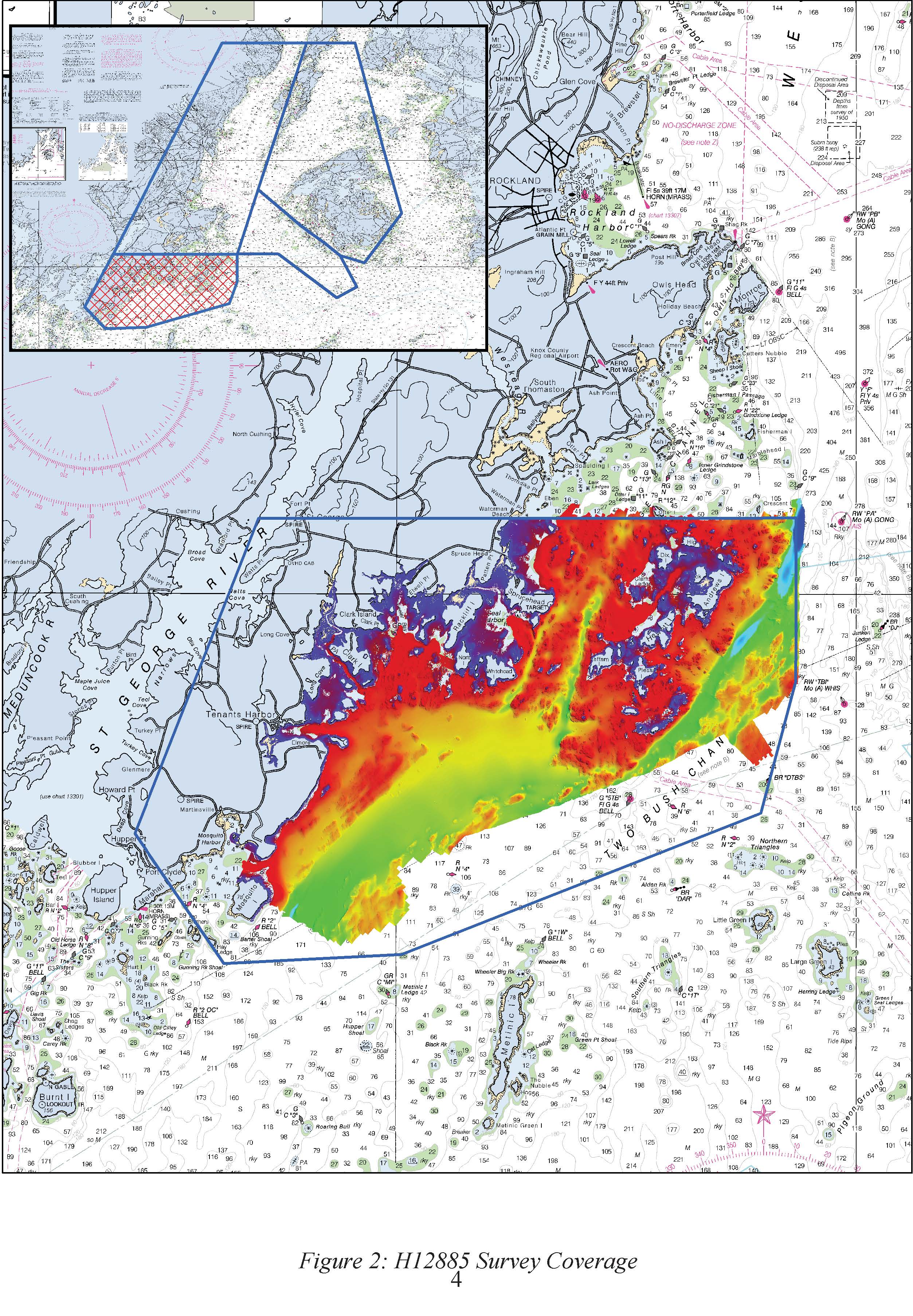
Federal
H12885: NOS Hydrographic Survey , 2016-09-29
National Oceanic and Atmospheric Administration, Department of Commerce —
The National Oceanic and Atmospheric Administration (NOAA) has the statutory mandate to collect hydrographic data in support of nautical chart compilation for safe...

Official websites use .gov
A
.gov website belongs to an official government
organization in the United States.
Secure .gov websites use HTTPS
A
lock (
) or https:// means you’ve safely connected to
the .gov website. Share sensitive information only on official,
secure websites.