
-
Federal
Autonomous Surface Vehicle Side-Scan-Sonar Mosaic of Apalachicola Bay, Florida
National Oceanic and Atmospheric Administration, Department of Commerce —
These data were collected under a cooperative mapping program between the U.S. Geological Survey (USGS), the National Oceanic and Atmospheric Administration Office... -
State
Lake Bathymetry Contours Lines
State of Connecticut —
See full Data Guide here. Lake Bathymetry describes the water depth for selected reservoirs, lakes, ponds, and coves in Connecticut. It includes depth contours, also... -
Federal
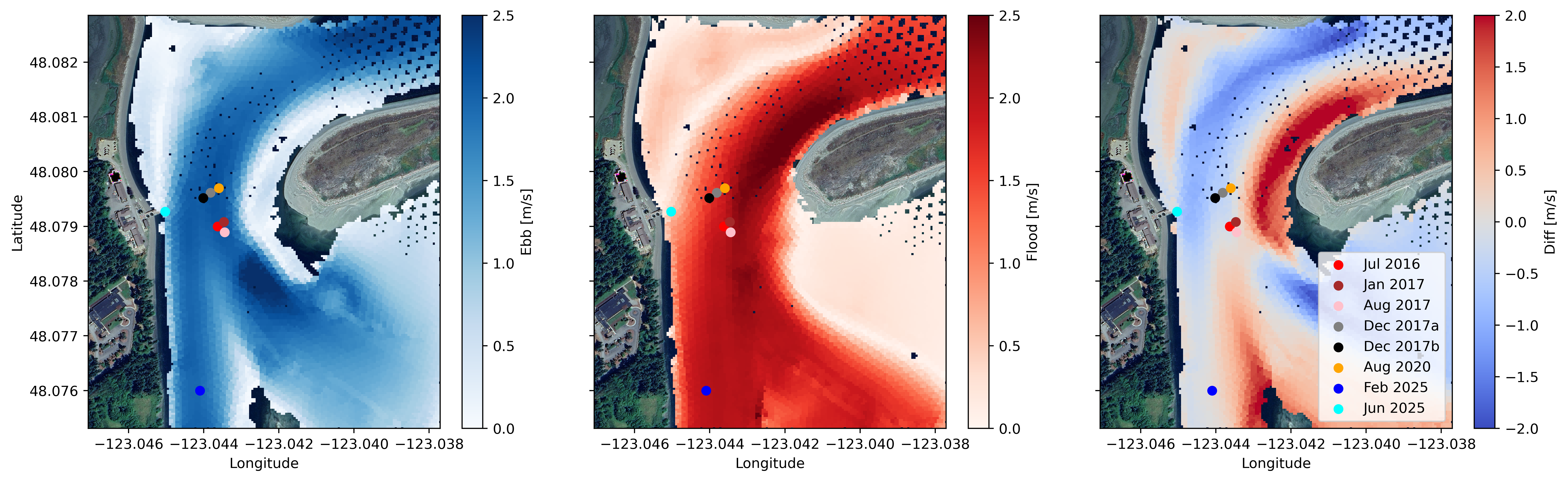
Water Velocity and Turbulence Data from Sequim Bay, WA, 2016 - 2025
Department of Energy —
Collection of publishable datasets from bottom-lander deployments of acoustic Doppler instrumentation in Sequim Bay, WA measured between 2016 and 2025. These data... -
Federal
Slope grid derived from gridded bathymetry of Galvez Bank, South Galvez Bank, and 11-Mile Reef, Territory of Guam, USA.
National Oceanic and Atmospheric Administration, Department of Commerce —
Slope is derived from gridded (5 m cell size) multibeam bathymetry, collected aboard NOAA Ship Oscar Elton Sette. Cell values reflect the maximum rate of change (in... -
Federal
Slope grid derived from gridded bathymetry of Farallon de Medinilla (FDM), Commonwealth of the Northern Mariana (CNMI), USA.
National Oceanic and Atmospheric Administration, Department of Commerce —
Slope is derived from gridded (5 m cell size) bathymetry for Farallon de medinilla (FDM). The bathymetry grid includes multibeam bathymetry from the Reson 8101... -
Federal
H13474: NOS Hydrographic Survey , 2021-10-07
National Oceanic and Atmospheric Administration, Department of Commerce —
The National Oceanic and Atmospheric Administration (NOAA) has the statutory mandate to collect hydrographic data in support of nautical chart compilation for safe... -
Federal
Slope grid (5 m) derived from gridded bathymetry of US Territory of Guam
National Oceanic and Atmospheric Administration, Department of Commerce —
Slope is derived from gridded (5 m cell size) bathymetry from four sources: Multibeam bathymetry collected by Coral Reef Ecosystem Division aboard NOAA R/V AHI, and... -
Federal
H13092: NOS Hydrographic Survey , 2017-11-09
National Oceanic and Atmospheric Administration, Department of Commerce —
The National Oceanic and Atmospheric Administration (NOAA) has the statutory mandate to collect hydrographic data in support of nautical chart compilation for safe... -
Federal
Side-Scan-Sonar Points for Hudson River, NY
National Oceanic and Atmospheric Administration, Department of Commerce —
Side Scan Point Files. These points correspond to individual pings which produced hte side-scan-sonar backscatter imagery. Sonar data were collected November 6 to... -
Federal
NOAA TIFF Image - 50m Multibeam Bathymetry, Charleston Bump - Deep Coral Priority Areas - Little Hales - (2003), UTM 17N NAD83
National Oceanic and Atmospheric Administration, Department of Commerce —
This dataset contains a unified GeoTiff with 30x30 meter cell size representing the bathymetry of the Charleston Bump off of the South Atlantic Bight, derived from... -
Federal
F00806: NOS Hydrographic Survey , 2021-08-18
National Oceanic and Atmospheric Administration, Department of Commerce —
The National Oceanic and Atmospheric Administration (NOAA) has the statutory mandate to collect hydrographic data in support of nautical chart compilation for safe... -
Federal
H13677: NOS Hydrographic Survey , 2022-12-04
National Oceanic and Atmospheric Administration, Department of Commerce —
The National Oceanic and Atmospheric Administration (NOAA) has the statutory mandate to collect hydrographic data in support of nautical chart compilation for safe... -
Federal
H13176: NOS Hydrographic Survey , 2019-06-21
National Oceanic and Atmospheric Administration, Department of Commerce —
The National Oceanic and Atmospheric Administration (NOAA) has the statutory mandate to collect hydrographic data in support of nautical chart compilation for safe... -
Federal
H13816: NOS Hydrographic Survey , 2023-12-07
National Oceanic and Atmospheric Administration, Department of Commerce —
The National Oceanic and Atmospheric Administration (NOAA) has the statutory mandate to collect hydrographic data in support of nautical chart compilation for safe... -
Federal
H13510: NOS Hydrographic Survey , 2021-09-06
National Oceanic and Atmospheric Administration, Department of Commerce —
The National Oceanic and Atmospheric Administration (NOAA) has the statutory mandate to collect hydrographic data in support of nautical chart compilation for safe... -
Federal
H13715: NOS Hydrographic Survey , 2023-09-22
National Oceanic and Atmospheric Administration, Department of Commerce —
The National Oceanic and Atmospheric Administration (NOAA) has the statutory mandate to collect hydrographic data in support of nautical chart compilation for safe... -
Federal
H13927: NOS Hydrographic Survey , 2024-09-27
National Oceanic and Atmospheric Administration, Department of Commerce —
The National Oceanic and Atmospheric Administration (NOAA) has the statutory mandate to collect hydrographic data in support of nautical chart compilation for safe... -
Federal
Gridded multibeam bathymetry of Baker Island, Pacific Remote Island Areas, Central Pacific
National Oceanic and Atmospheric Administration, Department of Commerce —
Gridded bathymetry at 40m resolution surrounding Baker Island, within the Pacific Remote Island Areas - Central Pacific Ocean. Bottom coverage was achieved in depths... -
Federal
U.S. Interagency Elevation Inventory (USIEI) - Data Download
National Oceanic and Atmospheric Administration, Department of Commerce —
The U.S. Interagency Elevation Inventory (USIEI) displays high-accuracy topographic and bathymetric data for the United States and its territories. The project is a... -
Federal
H12798: NOS Hydrographic Survey , 2017-08-31
National Oceanic and Atmospheric Administration, Department of Commerce —
The National Oceanic and Atmospheric Administration (NOAA) has the statutory mandate to collect hydrographic data in support of nautical chart compilation for safe...

Official websites use .gov
A
.gov website belongs to an official government
organization in the United States.
Secure .gov websites use HTTPS
A
lock (
) or https:// means you’ve safely connected to
the .gov website. Share sensitive information only on official,
secure websites.