

29 datasets found for "Bacteria Monitoring Stations"
-
Federal
TSIS TIM Level 3 Total Solar Irradiance 24-Hour Means V04 (TSIS_TSI_L3_24HR) at GES DISC
National Aeronautics and Space Administration —
Version 04 is the current release of this data product, and supercedes all previous versions.The TSIS TIM Level 3 Total Solar Irradiance (TSI) 24-Hour Means data... -
Federal
ISLSCP II Global Precipitation Climatology Centre (GPCC) Monthly Precipitation
National Aeronautics and Space Administration —
The Global Precipitation Climatology Centre (GPCC), which is operated by the Deutscher Wetterdienst (National Meteorological Service of Germany), is a component of... -
Federal
TSIS SIM Level 3 Solar Spectral Irradiance 12-Hour Means V13 (TSIS_SSI_L3_12HR) at GES DISC
National Aeronautics and Space Administration —
Version 13 is the current release of this data product, and supercedes all previous versions.The TSIS SIM Level 3 Solar Spectral Irradiance (SSI) 12-Hour Means data... -
Federal
SAGE III/ISS L2 Lunar Event Species Profiles (Native) V006
National Aeronautics and Space Administration —
g3blspb_6 is the Stratospheric Aerosol and Gas Experiment III (SAGE III) on the International Space Station (ISS) (SAGE III/ISS) Level 2 Lunar Event Species Profiles... -
Federal
Utah FORGE: Seismic Velocity Models, February 2021
Department of Energy —
This dataset contains a map, showing the Utah FORGE seismic stations, and seismic velocity model data. There are 61 1-D velocity models which are in a compressed TAR... -
Federal
Global Inventory of Methane Emissions from Fuel Exploitation V1 (GFEI_CH4)
National Aeronautics and Space Administration —
This is a global inventory of methane emissions from fuel exploitation (GFEI) created for the NASA Carbon Monitoring System (CMS). The emission sources represented in... -
Federal
MMR Calibration Data (FIFE)
National Aeronautics and Space Administration —
The MMR Calibration Data Set contains radiance data collected in the summer of 1987 and in July and August of 1989 via a Modular Multiband Radiometer (MMR)... -
Federal
LBA Regional Global Historical Climatology Network, V. 1, 1832-1990
National Aeronautics and Space Administration —
This data set consists of a subset of the Global Historical Climatology Network (GHCN) Version 1 database for the study area of the Large Scale Biosphere-Atmosphere... -
Federal
Stream Flow Daily Data: USGS (FIFE)
National Aeronautics and Space Administration —
The Daily Stream Flow Amounts Data Set contains daily measurements of stream flow for the four LTER stations and for the USGS stream-flow station located on... -
Federal
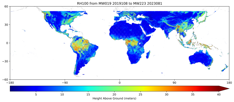
GEDI L3 Gridded Land Surface Metrics, Version 2
National Aeronautics and Space Administration —
This dataset provides Global Ecosystem Dynamics Investigation (GEDI) Level 3 (L3) gridded mean canopy height, standard deviation of canopy height, mean ground... -
Federal
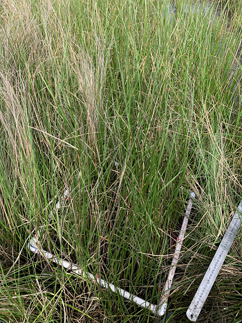
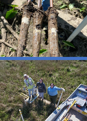
Delta-X: Feldspar Sediment Accretion Measurements, MRD, LA, USA, 2019-2023, Version 4
National Aeronautics and Space Administration —
This dataset provides elevation, hydrogeomorphic zone classification, soil carbon content, bulk density, organic matter content, and sediment accretion measurements... -
Federal
ABoVE: Soil Temperature Profiles, USArray Seismic Stations, 2016-2021
National Aeronautics and Space Administration —
This dataset includes soil temperature profile measurements taken at 63 monitoring sites associated with the USArray program, located across the NASA ABoVE domain in... -
Federal
TSIS SIM Level 3 Solar Spectral Irradiance 24-Hour Means V13 (TSIS_SSI_L3_24HR) at GES DISC
National Aeronautics and Space Administration —
Version 13 is the current release of this data product, and supercedes all previous versions.The TSIS SIM Level 3 Solar Spectral Irradiance (SSI) 24-Hour Means data... -
Federal
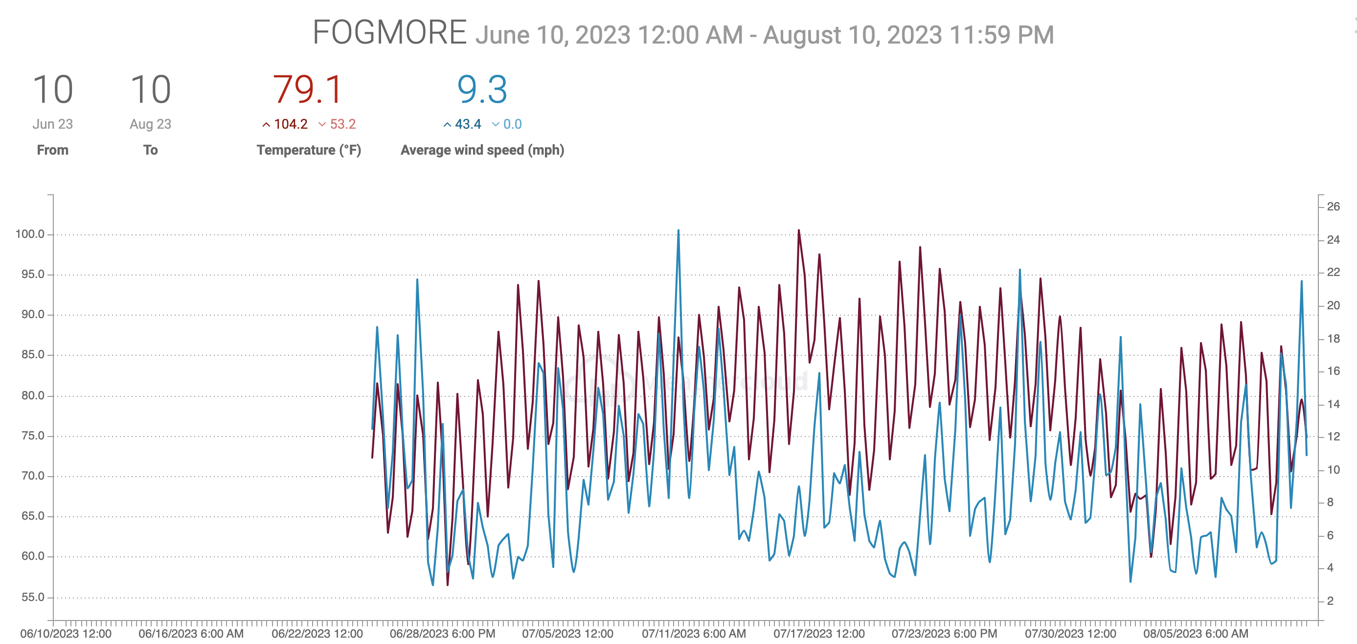
Hydrological and Water Chemistry Data: Faribault County, Minnesota, County Ditches 62 and 30, 2018—2023
Department of Agriculture —
This dataset includes drainage discharge, water chemistry, and precipitation data and GIS shapefiles for research conducted on 249-ha County Ditch 62 (CD62) and... -
Federal
Pre-LBA Anglo-Brazilian Amazonian Climate Observation Study (ABRACOS) Data
National Aeronautics and Space Administration —
The data set presents the principal data from the Anglo-BRazilian Amazonian Climate Observation Study (ABRACOS) (Gash et al, 1996) and provides quality controlled...
29 datasets found for "Bacteria Monitoring Stations"