
-
Federal
AMSR-E L2 Rainfall Subset, collocated with CloudSat track V002 (AMSERR_CPR) at GES DISC
National Aeronautics and Space Administration —
This is a subset of AMSR-E rain rate product along CloudSat field of view track. The goal of the subset is to select and return AMSR-E data that are within -100 km... -
Federal
Microwave oven interference measurements at 2.4 GHz
National Institute of Standards and Technology —
The 2.4 GHz ISM band is shared by Wi-Fi, Bluetooth, Wireless HART, ISA100.11a, and several other industrial wireless systems. This band also includes microwave ovens... -
Federal
TROPICS03 L2B Neural-network Atmospheric Vertical Temperature & Moisture Profiles V1.0
National Aeronautics and Space Administration —
The "Time-Resolved Observations of Precipitation structure and storm Intensity with a Constellation of Smallsats" (TROPICS) mission has a goal of providing nearly... -
Federal
TRMM Ground Validation Calibrated QC Radar Reflectivity Full Volume Scan L1C 1 hour V7 (TRMM_1C51) at GES DISC
National Aeronautics and Space Administration —
The purpose of the 1C51 algorithm is to remove non-meteorological radar echoes that adversely affect the quality of higher level products, such as clutter associated... -
Federal
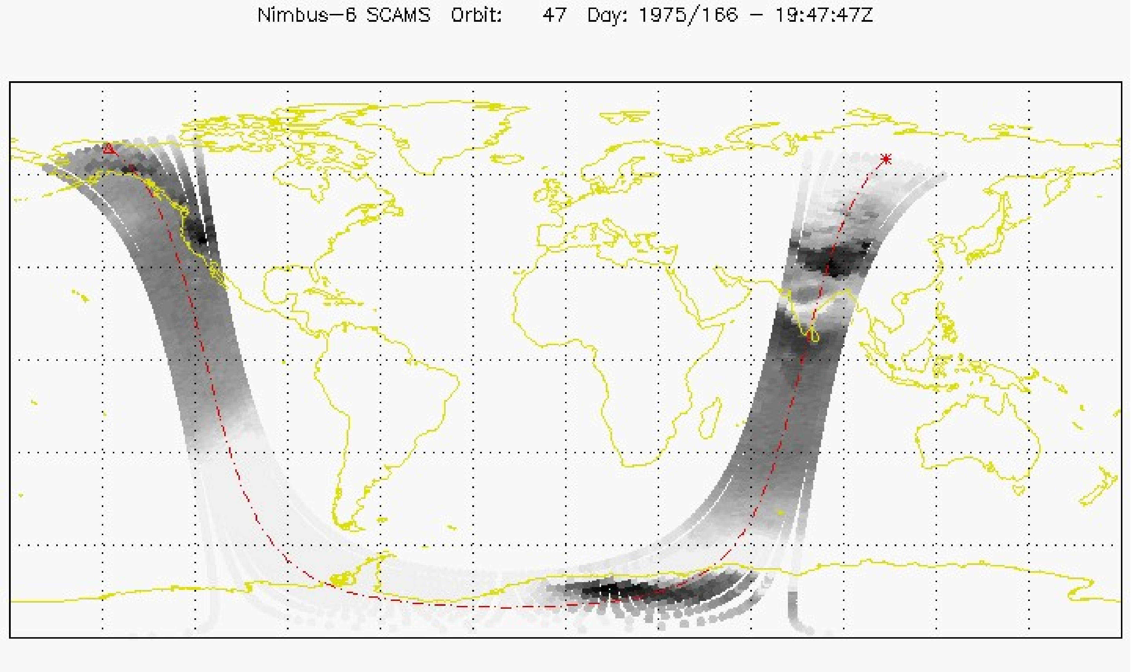
SCAMS/Nimbus-6 Level 2 Water Vapor and Temperature, as well as Antenna and Brightness Temperature V001 (SCAMSN6L2) at GES DISC
National Aeronautics and Space Administration —
The Nimbus-6 Scanning Microwave Spectrometer (SCAMS) Level 2 data product contains water vapor and temperature profiles, as well as antenna and brightness... -
Federal
TROPICS03 Pathfinder L2B Instantaneous Surface Rain Rate (ISRR) V1.0
National Aeronautics and Space Administration —
The "Time-Resolved Observations of Precipitation structure and storm Intensity with a Constellation of Smallsats" (TROPICS) mission has a goal of providing nearly... -
Federal
TROPICS05 L2B Neural-network Atmospheric Vertical Temperature & Moisture Profiles V0.2
National Aeronautics and Space Administration —
The "Time-Resolved Observations of Precipitation structure and storm Intensity with a Constellation of Smallsats" (TROPICS) mission has a goal of providing nearly... -
Federal
TRMM Microwave Imager Calibrated Radiances L1B 1.5 hours V7 (TRMM_1B11) at GES DISC
National Aeronautics and Space Administration —
This dataset contains TRMM Micrwave Imager (TMI) L1B calibrated radiances in terms of Brightness Temperatures. The TMI calibration algorithm (1B11) converts the... -
Federal
TRMM Ground Validation Calibrated QC Radar Reflectivity Full Volume Scan L1C 1 hour V7 (TRMM_1C51UW) at GES DISC
National Aeronautics and Space Administration —
This dataset is part of the University of Washington TRMM Ground Validation products. Files are in "Universal Format", described in BAMS, Vol 61, No 11, November... -
Federal
GPM GMI Brightness Temperatures L1B 1.5 hours 13 km V07 (GPM_1BGMI) at GES DISC
National Aeronautics and Space Administration —
Version 07 is the current version of the data set. Older versions will no longer be available and have been superseded by Version 07.The 1BGMI algorithm uses a non-... -
Federal
TROPICS03 L1A Orbital Geolocated Native-Resolution Antenna Temperatures V1.0
National Aeronautics and Space Administration —
The "Time-Resolved Observations of Precipitation structure and storm Intensity with a Constellation of Smallsats" (TROPICS) mission has a goal of providing nearly... -
Federal
TROPICS01 Pathfinder L2A Unified Resolution Brightness Temperatures V1.0
National Aeronautics and Space Administration —
The "Time-Resolved Observations of Precipitation structure and storm Intensity with a Constellation of Smallsats" (TROPICS) mission has a goal of providing nearly... -
Federal
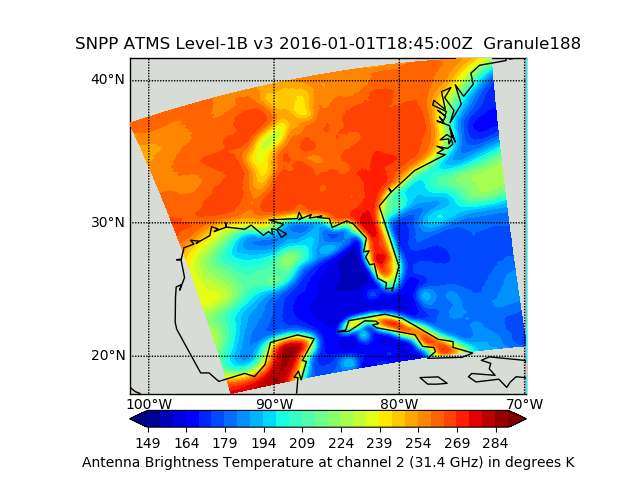
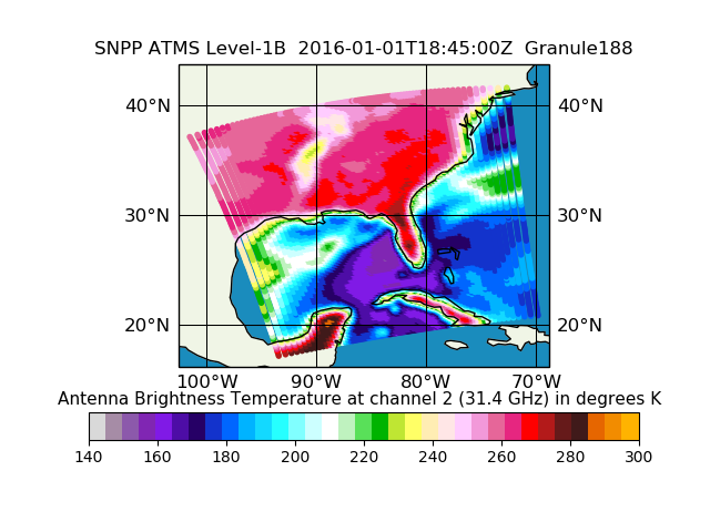
Suomi NPP ATMS Sounder Science Investigator-led Processing System (SIPS) Level 1B Brightness Temperature V3 (SNPPATMSL1B) at GES DISC
National Aeronautics and Space Administration —
The Advanced Technology Microwave Sounder (ATMS) Level 1B data files contain brightness temperature measurements along with ancillary spacecraft, instrument, and... -
Federal
TROPICS01 Pathfinder L1A Orbital Geolocated Native-Resolution Antenna Temperatures V1.0
National Aeronautics and Space Administration —
The "Time-Resolved Observations of Precipitation structure and storm Intensity with a Constellation of Smallsats" (TROPICS) mission has a goal of providing nearly... -
Federal
TROPICS03 L1A Orbital Geolocated Native-Resolution Antenna Temperatures V1.0
National Aeronautics and Space Administration —
The "Time-Resolved Observations of Precipitation structure and storm Intensity with a Constellation of Smallsats" (TROPICS) mission has a goal of providing nearly... -
Federal
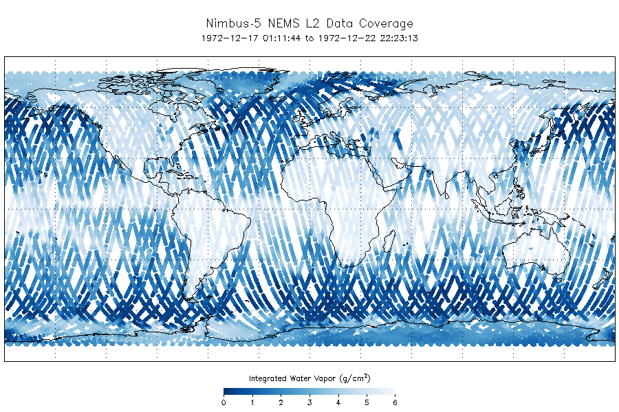
NEMS/Nimbus-5 Level 2 Output Data V001 (NEMSN5L2) at GES DISC
National Aeronautics and Space Administration —
NEMSN5L2 is the Nimbus-5 or Nimbus-E Microwave Spectrometer (NEMS) Level-2 Output Data product and contains surface reflectivity, water vapor, liquid water, layer... -
Federal
JPSS-1 ATMS Level 1B Brightness Temperature V2 (SNDRJ1ATMSL1B) at GES DISC
National Aeronautics and Space Administration —
The Advanced Technology Microwave Sounder (ATMS) Level 1B data files contain brightness temperature measurements along with ancillary spacecraft, instrument, and... -
Federal
GPS Radio Occultation Boundary Layer Depth Seasonal L3 V1 (GPSROZPBLS) at GES DISC
National Aeronautics and Space Administration —
This dataset has been superseded by version 2. It provides seasonal averages of a global planetary boundary layer (PBL) height climatology derived from the... -
Federal
TROPICS05 L2B Tropical Cyclone Intensity Estimate (TCIE) Algorithm V1.0
National Aeronautics and Space Administration —
The "Time-Resolved Observations of Precipitation structure and storm Intensity with a Constellation of Smallsats" (TROPICS) mission has a goal of providing nearly... -
Federal
SWOT Level 1B High-Rate Single-look Complex Data Product, Version D
National Aeronautics and Space Administration —
High rate data processed to single-look complex SAR images for each antenna. Gridded tile (approx 64x64 km2); half swath (left or right side of full swath). Available...

Official websites use .gov
A
.gov website belongs to an official government
organization in the United States.
Secure .gov websites use HTTPS
A
lock (
) or https:// means you’ve safely connected to
the .gov website. Share sensitive information only on official,
secure websites.