
-
Federal
NACP Integrated Wildland and Cropland 30-m Fuel Characteristics Map, U.S.A., 2010
National Aeronautics and Space Administration —
The data set provides a 30-m comprehensive fuelbed characteristics map for both the wildland and cropland areas of the conterminous United States (CONUS) for 2010.... -
Federal
LBA-ECO LC-08 Soil, Vegetation, and Land Cover Maps for Brazil and South America
National Aeronautics and Space Administration —
This data set provides (1) soil maps for Brazil that are digital versions of the MAPA DE SOLOS DO BRASIL (EMBRAPA, 1981) classified at three levels of detail,... -
Federal
LBA Regional Derived Soil Properties, 0.5-Deg (ISRIC-WISE)
National Aeronautics and Space Administration —
The data set consists of a subset of the ISRIC-WISE global data set of derived soil properties for the study area of the Large Scale Biosphere-Atmosphere Experiment... -
Federal
ASTER L2 Surface Radiance TIR V003
National Aeronautics and Space Administration —
The Terra Advanced Spaceborne Thermal Emission and Reflection Radiometer (ASTER) Surface Radiance TIR (AST_09T) is generated using the five Thermal Infrared (TIR)... -
Federal
SAFARI 2000 Derived Soil Properties, 0.5-Deg (ISRIC-WISE)
National Aeronautics and Space Administration —
The data set consists of a southern Africa subset of the ISRIC-WISE global data set of derived soil properties. The World Inventory of Soil Emission Potentials (WISE)... -
Federal
NPP Multi-Biome: Gridded Estimates for Selected Regions Worldwide, 1954-1998, R3
National Aeronautics and Space Administration —
This data set provides two data files (.csv format) containing gridded (0.5-degree) estimates of net primary productivity (NPP), elevation, temperature,... -
Federal
Global Data Set of Derived Soil Properties, 0.5-Degree Grid (ISRIC-WISE)
National Aeronautics and Space Administration —
The World Inventory of Soil Emission Potentials (WISE) database currently contains data for over 4300 soil profiles collected mostly between 1950 and 1995. This... -
Federal
Australia Telescope-PMN Catalog of Southern Radio Sources
National Aeronautics and Space Administration —
This table contains a source catalog of 9040 radio sources derived from high-resolution observations of a selection of 8385 Parkes-MIT-NRAO (PMN) sources made with... -
Federal
Fermi GBM Burst Catalog
National Aeronautics and Space Administration —
When referencing results from this online catalog, please cite von Kienlin, A. et al. 2020, Gruber, D. et al. 2014, von Kienlin, A. et al. 2014, and Bhat, P. et al.... -
Federal
A Materials Properties Dataset for Elastomeric Foam Impact Mitigating Materials
National Institute of Standards and Technology —
The database includes mechanical data for structure-properties relationships and mechanical modeling of elastic impact protection foams from a variety of imaging... -
Federal
DE 2 Vector Electric Field Instrument, VEFI, Magnetometer, MAG-B, Merged Magnetic and Electric Field Parameters, 62 ms Data
National Aeronautics and Space Administration —
This Dynamics Explorer 2, DE 2, data set is a combination of the Vector Electric Field Instrument, VEFI, and Magnetometer-B, MAGB, high resolution data sets in... -
Federal
Industrial Facility Combustion Energy Use
Department of Energy —
Facility-level industrial combustion energy use is calculated from greenhouse gas emissions data reported by large emitters (>25,000 metric tons CO2e per year)... -
Federal
SORCE XPS Level 4 Solar Spectral Irradiance 0.1nm Res 5-Minute V012 (SOR4XPS5) at GES DISC
National Aeronautics and Space Administration —
The SORCE XPS Level 4 Solar Spectral Irradiance 0.1nm Res 5-Minute product (SOR4XPS5) contains modelled spectral extreme ultraviolet (XUV) irradiances based on... -
Federal
SORCE XPS Level 4 Solar Spectral Irradiance 0.1nm Res 24-Hour Means V012 (SOR4XPSD_HIGH) at GES DISC
National Aeronautics and Space Administration —
The SORCE XPS Level 4 Solar Spectral Irradiance 0.1nm Res 24-Hour Means product (SOR4XPSD_HIGH) contains modelled spectral extreme ultraviolet (XUV) irradiances based... -
Federal
SORCE XPS Level 4 Solar Spectral Irradiance 1.0nm Res 24-Hour Means V012 (SOR4XPSD_LOW) at GES DISC
National Aeronautics and Space Administration —
The SORCE XPS Level 4 Solar Spectral Irradiance 1.0nm Res 24-Hour Means product (SOR4XPSD_LOW) contains modelled spectral extreme ultraviolet (XUV) irradiances based... -
Federal
PROVE Land Cover and Leaf Area of Jornada Experimental Range, New Mexico, 1997
National Aeronautics and Space Administration —
Field measurement of shrubland ecological properties is important for both site monitoring and validation of remote-sensing information. During the NASA Earth... -
Federal
LBA-ECO ND-04 Secondary Forest Recovery, Structure, and LAI, Central Amazonia, Brazil
National Aeronautics and Space Administration —
This data set reports measurements of the canopy and structure of secondary forests regenerating from abandoned pastures. These secondary forests are located in the... -
Federal
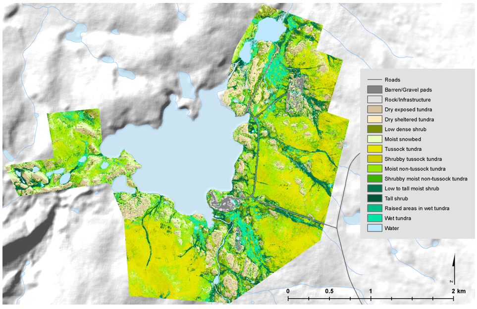
High-Resolution Vegetation Community Maps, Toolik Lake Area, Alaska, 2013-2015
National Aeronautics and Space Administration —
This dataset contains vegetation community maps at 20 cm resolution for three landscapes near the Toolik Lake research area in the northern foothills of the Brooks... -
Federal
ISLSCP II Climate Research Unit CRU05 Monthly Climate Data
National Aeronautics and Space Administration —
This data set contains a mean monthly climatology for several climate variables averaged over the period from 1961 to 1990, and constructed from a data set of station...

Official websites use .gov
A
.gov website belongs to an official government
organization in the United States.
Secure .gov websites use HTTPS
A
lock (
) or https:// means you’ve safely connected to
the .gov website. Share sensitive information only on official,
secure websites.