
-
Federal
Tycho-2 Catalog of the 2.5 Million Brightest Stars
National Aeronautics and Space Administration —
The Hipparcos and Tycho catalogs are the primary products of the European Space Agency's astrometric mission, Hipparcos. The satellite, which operated for four years,... -
Federal
Substance Identification Information from EPA's Substance Registry
U.S. Environmental Protection Agency —
The Substance Registry Services (SRS) is the authoritative resource for basic information about substances of interest to the U.S. EPA and its state and tribal... -
Federal
MERRA-2 tavgM_2d_aer_Nx: 2d,Monthly mean,Time-averaged,Single-Level,Assimilation,Aerosol Diagnostics 0.625 x 0.5 degree V5.12.4 (M2TMNXAER) at GES DISC
National Aeronautics and Space Administration —
M2TMNXAER (or tavgM_2d_aer_Nx) is a time-averaged 2-dimensional monthly mean data collection in Modern-Era Retrospective analysis for Research and Applications... -
Federal
NACP North American Forest Dynamics Project: Forest Disturbance and Regrowth Data
National Aeronautics and Space Administration —
This data set provides the results of time-series analyses of Landsat imagery for 55 selected forested sites across the conterminous U.S.A. The output is a pair of... -
Federal
Microbiological and nutritional analysis of lettuce crops grown on the International Space Station-VEG01A
National Aeronautics and Space Administration —
The ability to grow safe, fresh food to supplement packaged foods of astronauts in space has been an important goal for NASA. Food crops grown in space experience... -
Federal
X-Ray Selected High-z AGN Catalog
National Aeronautics and Space Administration —
This table contains the results from an analysis of the largest high-redshift (z > 3) X-ray-selected active galactic nucleus (AGN) sample to date, combining the... -
Federal
ASTER Digital Elevation Model V004
National Aeronautics and Space Administration —
The Terra Advanced Spaceborne Thermal Emission and Reflection Radiometer (ASTER) Digital Elevation Model (AST14DEM) product is generated using bands 3N (nadir-... -
Federal
SBUV2/NOAA-18 Ozone (O3) Profile and Total Column Ozone 1 Month Zonal Mean L3 Global 5.0 degree Latitude Zones V1 (SBUV2N18L3zm) at GES DISC
National Aeronautics and Space Administration —
The Solar Backscattered Ultraviolet (SBUV) from NOAA-18 Level-3 monthly zonal mean (MZM) product (SBUV2N18L3zm) is derived from the Level-2 retrieved ozone profiles.... -
Federal
MODIS/Terra Surface Reflectance 8-Day L3 Global 250m SIN Grid V006
National Aeronautics and Space Administration —
The MOD09Q1 Version 6 data product was decommissioned on July 31, 2023. Users are encouraged to use the MOD09Q1 Version 6.1 data product.The MOD09Q1 Version 6 product... -
Federal
ECOSTRESS Evapotranspiration dis-ALEXI USDA Daily L3 Global 30m V001
National Aeronautics and Space Administration —
The ECOsystem Spaceborne Thermal Radiometer Experiment on Space Station (ECOSTRESS) mission measures the temperature of plants to better understand how much water... -
Federal
Wind 3DP SST Foil Electron Omnidirectional Fluxes
National Aeronautics and Space Administration —
Electron omnidirectional fluxes 27-520 keV, often at 24 sec, SST Foil, Wind 3DP - R. Lin (UC Berkeley) -
Federal
ATom: Merged Atmospheric Chemistry, Trace Gases, and Aerosols, Version 2
National Aeronautics and Space Administration —
This dataset provides information on greenhouse gases and human-produced air pollution, including atmospheric concentrations of carbon dioxide (CO2), methane (CH4),... -
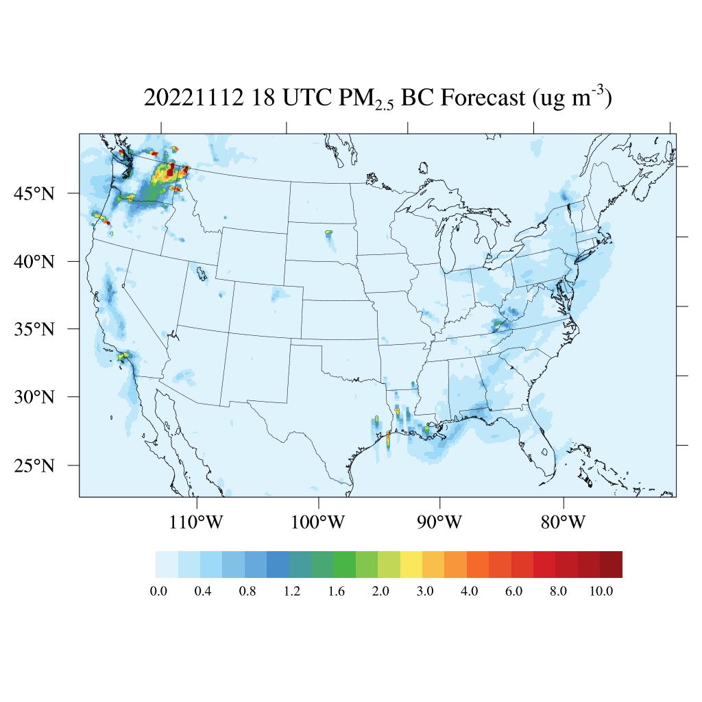
Federal
HAQES 3-Hourly Ensemble mean surface PM2.5 Black Carbon concentration, North America V1 (HAQES_NA_PM25_BC) at GES DISC
National Aeronautics and Space Administration —
This product provides HAQES 3-hourly ensemble mean surface PM2.5 Black Carbon concentration over the continental United States (CONUS) and surrounding regions. The... -
Federal
MOOSE NASA G-3 Aircraft GEO-CAPE Airborne Simulator (GCAS) Remotely Sensed Data
National Aeronautics and Space Administration —
MOOSE_AircraftRemoteSensing_NASA-G3_GCAS_Data contains remotely sensed data collected by the GEOstationary Coastal and Air Pollution Events (GEO-CAPE) Airborne... -
Federal
Fermi GBM Trigger Catalog
National Aeronautics and Space Administration —
This table lists all of the triggers observed by one or more of the 14 GBM detectors (12 NaI and 2 BGO). Note that there are two Browse catalogs resulting from GBM... -
Federal
GPM GROUND VALIDATION DC-8 CAMERA NADIR GCPEX
National Aeronautics and Space Administration —
The GPM Ground Validation DC-8 Camera Nadir GCPEx dataset contains geo-located, visible-wavelength imagery of the ground obtained from the nadir camera aboard the... -
Federal
Arctic Vegetation Plots for IBP Tundra Biome, Barrow, Alaska, 1972-2010
National Aeronautics and Space Administration —
This data set provides vegetation cover and environmental plot data collected as part of the International Biological Program (IBP), U. S. Tundra Biome Program, in... -
Federal
MODIS/Terra Surface Reflectance Daily L2G Global 1km and 500m SIN Grid V006
National Aeronautics and Space Administration —
The MOD09GA Version 6 data product was decommissioned on July 31, 2023. Users are encouraged to use the MOD09GA Version 6.1 data product.The MOD09GA Version 6 product... -
Federal
VIIRS/NPP Lunar BRDF-Adjusted Nighttime Lights Yearly L3 Global 15 arc-second Linear Lat Lon Grid
National Aeronautics and Space Administration —
VIIRS/NPP Lunar BRDF-Adjusted Nighttime Lights Yearly L3 Global 15 arc-second Linear Lat Lon Grid, with short-name VNP46A4, is the third nighttime lights (NTL)...

Official websites use .gov
A
.gov website belongs to an official government
organization in the United States.
Secure .gov websites use HTTPS
A
lock (
) or https:// means you’ve safely connected to
the .gov website. Share sensitive information only on official,
secure websites.