
-
Federal
NOAA/WDS Paleoclimatology - Power et al. 2008 Global Charcoal Database
National Oceanic and Atmospheric Administration, Department of Commerce —
This archived Paleoclimatology Study is available from the NOAA National Centers for Environmental Information (NCEI), under the World Data Service (WDS) for... -
Federal
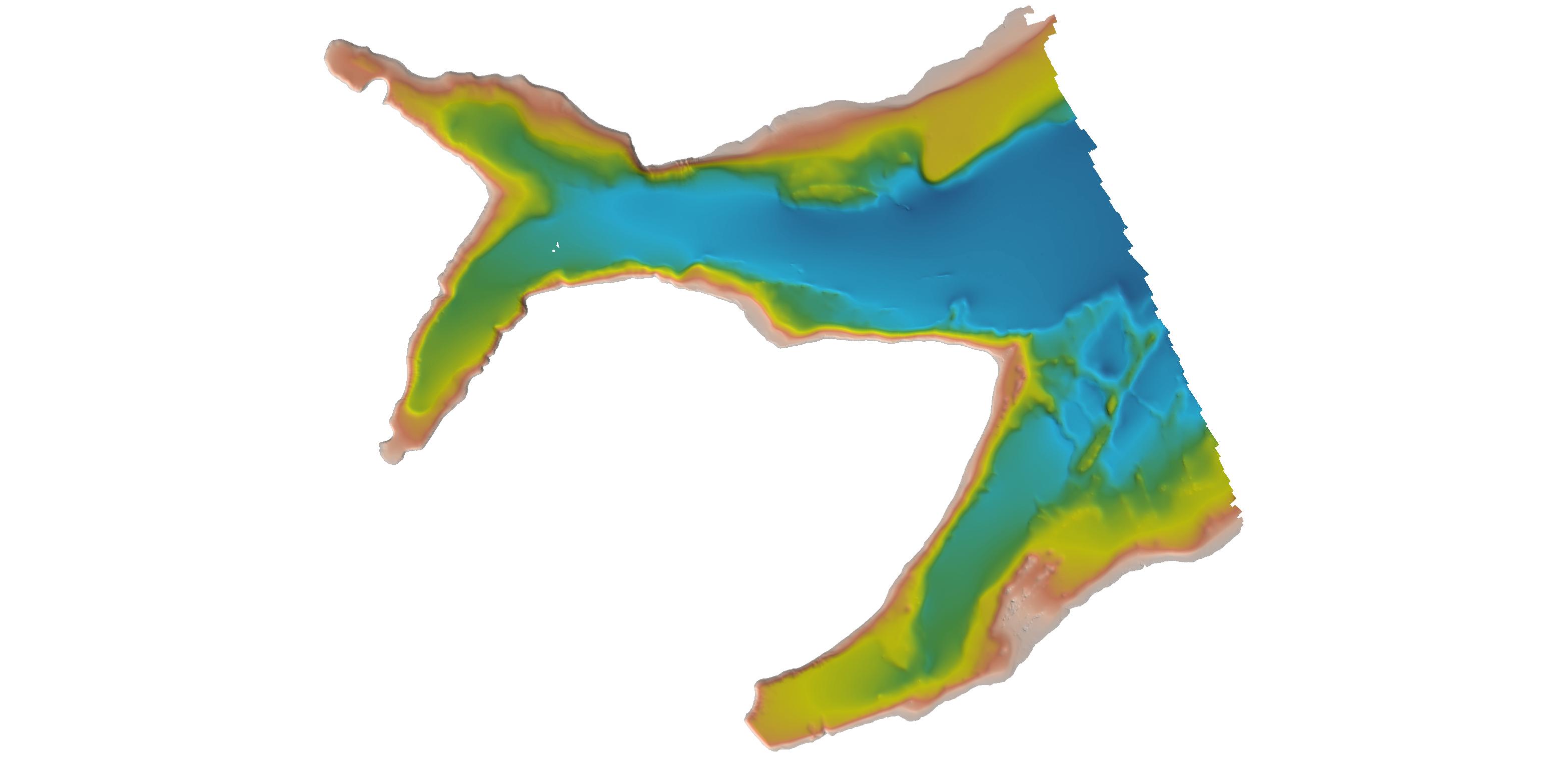
Coastal Digital Elevation Models (DEMs)
National Oceanic and Atmospheric Administration, Department of Commerce —
Digital elevation models (DEMs) of U.S. and other coasts that typically integrate ocean bathymetry and land topography. The DEMs support NOAA's mission to understand... -
Federal
R-Factor for the Conterminous United States
National Oceanic and Atmospheric Administration, Department of Commerce —
The rainfall-runoff erosivity factor (R-Factor) quantifies the effects of raindrop impacts and reflects the amount and rate of runoff associated with the rain. The... -
Federal
2025 NOAA NGS Ortho-rectified 4 band Mosaic of Bangor, Bremerton, Keyport and Manchester, WA
National Oceanic and Atmospheric Administration, Department of Commerce —
This data set contains 4-band ortho-rectified mosaic tiles, created as a product from the NOAA Integrated Ocean and Coastal Mapping (IOCM) initiative. The source... -
Federal
Airborne Gravity Data - Gravity for the Redefinition of the American Vertical Datum (GRAV-D) NGDA
National Oceanic and Atmospheric Administration, Department of Commerce —
Gravity for the Re-definition of the American Vertical Datum (GRAV-D) is a project initiated by NOAA's National Geodetic Survey to collect and monitor gravity data... -
Federal
2022 - 2023 NOAA USGS Lidar: Hawaii (Kahoolawe, Lanai, Maui, Molokai, Oahu)
National Oceanic and Atmospheric Administration, Department of Commerce —
Original Dataset Product: Processed, classified lidar point cloud data tiles in LAZ 1.4 format. Original Dataset Geographic Extent: HI_NOAAMauiOahu_1: The work unit... -
Federal
NOAA Office for Coastal Management Coastal Inundation Digital Elevation Model: Florida, SE
National Oceanic and Atmospheric Administration, Department of Commerce —
These data were created as part of the National Oceanic and Atmospheric Administration Office for Coastal Management's efforts to create an online mapping viewer... -
Federal
New Orleans, Louisiana 1/3 arc-second MHW Coastal Digital Elevation Model
National Oceanic and Atmospheric Administration, Department of Commerce —
NOAA's National Geophysical Data Center (NGDC) is building high-resolution digital elevation models (DEMs) for select U.S. coastal regions in the Gulf of Mexico.... -
Federal
Shoreline Mapping Program of Cape Cod Bay, Nobscusset Point to Eastham, MA, MA1101G-CM-N NGDA
National Oceanic and Atmospheric Administration, Department of Commerce —
These data provide an accurate high-resolution shoreline compiled from imagery of Cape Cod Bay, Nobscusset Point to Eastham, MA . This vector shoreline data is based... -
Federal
2018-2019 NOAA NGS Topobathy Lidar DEM Hurricane Irma Delivery 1: Miami to Key Largo, FL
National Oceanic and Atmospheric Administration, Department of Commerce —
The NOAA Hurricane Irma Florida Keys Topobathymetric LiDAR Delivery 1 area data were collected by Quantum Spatial, Inc. (QSI) using three Riegl systems: a Riegl... -
Federal
Coastal Mapping Program of Matagorda Bay to East Matagorda Bay, TX, TX1803D-TB-C NGDA
National Oceanic and Atmospheric Administration, Department of Commerce —
These data provide an accurate high-resolution shoreline compiled from imagery of Matagorda Bay to East Matagorda Bay, TX . This vector shoreline data is based on an... -
Federal
Southeast Alaska 8/3 arc-second MHHW Coastal Digital Elevation Model
National Oceanic and Atmospheric Administration, Department of Commerce —
NOAA's National Geophysical Data Center (NGDC) is building high-resolution digital elevation models (DEMs) to support individual coastal States as part of the... -
Federal
H13171: NOS Hydrographic Survey , 2018-12-07
National Oceanic and Atmospheric Administration, Department of Commerce —
The National Oceanic and Atmospheric Administration (NOAA) has the statutory mandate to collect hydrographic data in support of nautical chart compilation for safe... -
Federal
H11195: NOS Hydrographic Survey , Southwest Alaska Peninsula, Alaska, 2003-06-06
National Oceanic and Atmospheric Administration, Department of Commerce —
The National Oceanic and Atmospheric Administration (NOAA) has the statutory mandate to collect hydrographic data in support of nautical chart compilation for safe... -
Federal
F00247: NOS Hydrographic Survey , Atlantic Beach, North Carolina, 1983-06-01
National Oceanic and Atmospheric Administration, Department of Commerce —
The National Oceanic and Atmospheric Administration (NOAA) has the statutory mandate to collect hydrographic data in support of nautical chart compilation for safe... -
Federal
L01919: NOS Hydrographic Survey , 1948-12-31
National Oceanic and Atmospheric Administration, Department of Commerce —
The National Oceanic and Atmospheric Administration (NOAA) has the statutory mandate to collect hydrographic data in support of nautical chart compilation for safe... -
Federal
NOAA/WDS Paleoclimatology - Fennoscandia 7500Yr Pollen-TreeRing July Temperature Reconstructions
National Oceanic and Atmospheric Administration, Department of Commerce —
This archived Paleoclimatology Study is available from the NOAA National Centers for Environmental Information (NCEI), under the World Data Service (WDS) for... -
Federal
NOAA/WDS Paleoclimatology - LAKE STATUS RECORDS FROM EUROPE: DATA BASE DOCUMENTATION
National Oceanic and Atmospheric Administration, Department of Commerce —
This archived Paleoclimatology Study is available from the NOAA National Centers for Environmental Information (NCEI), under the World Data Service (WDS) for... -
Federal
West Coast Groundfish Bottom Trawl Survey Data - 2020 West Coast Groundfish Bottom Trawl Survey and indices of abundance
National Oceanic and Atmospheric Administration, Department of Commerce —
The Fisheries Research Survey team proposes to conduct the West Coast Groundfish Bottom Trawl Survey from May to October 2019. The goal of the survey is to ensure the...

Official websites use .gov
A
.gov website belongs to an official government
organization in the United States.
Secure .gov websites use HTTPS
A
lock (
) or https:// means you’ve safely connected to
the .gov website. Share sensitive information only on official,
secure websites.
.jpg)
.jpg)