
-
Federal
NOAA/WDS Paleoclimatology - CLIMAP 18K Database
National Oceanic and Atmospheric Administration, Department of Commerce —
This archived Paleoclimatology Study is available from the NOAA National Centers for Environmental Information (NCEI), under the World Data Service (WDS) for... -
Federal
NOAA/WDS Paleoclimatology - Power et al. 2008 Global Charcoal Database
National Oceanic and Atmospheric Administration, Department of Commerce —
This archived Paleoclimatology Study is available from the NOAA National Centers for Environmental Information (NCEI), under the World Data Service (WDS) for... -
Federal
DCLDE 2026: Killer whale (Orcinus orca) ecotype and other species annotations for the Detection Classification Localization and Density Estimate (DCLDE) conference in 2026
National Oceanic and Atmospheric Administration, Department of Commerce —
Killer whales (Orcinus orca) exhibit significant ecological and genetic diversity, with three primary sympatric ecotypes in the Northeast Pacific: Resident, Biggâs... -
Federal
Sea Level Trends: Sea Level Variations of the United States Derived from National Water Level Observation Network Stations NGDA
National Oceanic and Atmospheric Administration, Department of Commerce —
Water level records are a combination of the fluctuations of the ocean and the vertical land motion at the location of the station. Monthly mean sea level (MSL)... -
Federal
National Status and Trends: Mussel Watch Program
National Oceanic and Atmospheric Administration, Department of Commerce —
Mussel Watch is the longest running continuous chemical contaminant monitoring program in U.S. coastal and Great Lakes waters and was created in response to concerns... -
Federal
Meteorological Data (including visibility)
National Oceanic and Atmospheric Administration, Department of Commerce —
The National Ocean Service (NOS) maintains a long-term database containing data from active and historic stations installed all over the United States and U.S.... -
Federal
Hawaii Volcanism: Impact on the Environment
National Oceanic and Atmospheric Administration, Department of Commerce —
Fewer than one hundred people have been killed by eruptions in the recorded history of Hawaii, and only one death has occurred in the 20th Century. However, the lava... -
Federal
Shorelines of the Louisiana coastal region used in shoreline change analysis
Department of the Interior —
Sandy ocean beaches are a popular recreational destination, often surrounded by communities containing valuable real estate. Development is on the rise despite the... -
Federal
NOAA ENC Direct to GIS
National Oceanic and Atmospheric Administration, Department of Commerce —
NOAA's Electronic Navigational Charts (NOAA ENCs) have been developed to support the marine transportation infrastructure and coastal management. The NOAA ENCs are in... -
Federal
Physical Oceanographic (Water Temperature and Conductivity) Data
National Oceanic and Atmospheric Administration, Department of Commerce —
NOAA's Center for Operational Oceanographic Products and Services (CO-OPS) is the authoritative source for accurate, reliable, and timely data on tides, water levels,... -
Federal
High Tide Flooding Products from NOAA CO-OPS
National Oceanic and Atmospheric Administration, Department of Commerce —
High tide flooding is the overflow or excess accumulation of water that covers typically dry coastal land and occurs during high tides. As relative sea levels rise,... -
Federal
Southeast Alaska 8/3 arc-second MHHW Coastal Digital Elevation Model
National Oceanic and Atmospheric Administration, Department of Commerce —
NOAA's National Geophysical Data Center (NGDC) is building high-resolution digital elevation models (DEMs) to support individual coastal States as part of the... -
Federal
Palmyra Atoll Quickbird II Terrestrial Mosaic (1.8m)
National Oceanic and Atmospheric Administration, Department of Commerce —
Benthic habitat maps of the nearshore marine environment of Pamyra Atoll were created by visual interpretation of remotely sensed imagery. The objective of this... -
Federal
NOAA Coastal Mapping Shoreline Products NGDA
National Oceanic and Atmospheric Administration, Department of Commerce —
The NOAA Coastal Mapping Shoreline Products from the Remote Sensing Division are primarily for application to the nautical charts produced by NOAA's Office of Coast... -
Federal
National Estuarine Research Reserve System - NERRS - Meteorological Data
National Oceanic and Atmospheric Administration, Department of Commerce —
Meteorological data provide information on atmospheric conditions that can affect water quality and biological and physical processes. Core elements currently... -
Federal
NOAA/WDS Paleoclimatology - Cook et al. 2008 North American Drought Atlas Version 2a
National Oceanic and Atmospheric Administration, Department of Commerce —
This archived Paleoclimatology Study is available from the NOAA National Centers for Environmental Information (NCEI), under the World Data Service (WDS) for... -
Federal
H06678: NOS Hydrographic Survey , 1941-12-31
National Oceanic and Atmospheric Administration, Department of Commerce —
The National Oceanic and Atmospheric Administration (NOAA) has the statutory mandate to collect hydrographic data in support of nautical chart compilation for safe... -
Federal
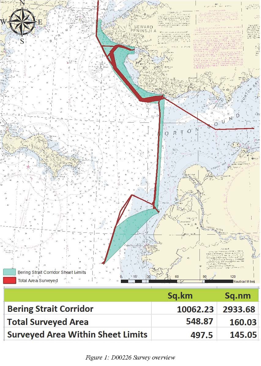
D00226: NOS Hydrographic Survey , 2017-09-04
National Oceanic and Atmospheric Administration, Department of Commerce —
The National Oceanic and Atmospheric Administration (NOAA) has the statutory mandate to collect hydrographic data in support of nautical chart compilation for safe... -
Federal
H05104: NOS Hydrographic Survey , 1930-12-31
National Oceanic and Atmospheric Administration, Department of Commerce —
The National Oceanic and Atmospheric Administration (NOAA) has the statutory mandate to collect hydrographic data in support of nautical chart compilation for safe...

Official websites use .gov
A
.gov website belongs to an official government
organization in the United States.
Secure .gov websites use HTTPS
A
lock (
) or https:// means you’ve safely connected to
the .gov website. Share sensitive information only on official,
secure websites.