
-
Federal
NOAA/WDS Paleoclimatology - CLIMAP 18K Database
National Oceanic and Atmospheric Administration, Department of Commerce —
This archived Paleoclimatology Study is available from the NOAA National Centers for Environmental Information (NCEI), under the World Data Service (WDS) for... -
Federal
NOAA/WDS Paleoclimatology - Power et al. 2008 Global Charcoal Database
National Oceanic and Atmospheric Administration, Department of Commerce —
This archived Paleoclimatology Study is available from the NOAA National Centers for Environmental Information (NCEI), under the World Data Service (WDS) for... -
Federal
test postSandy
National Oceanic and Atmospheric Administration, Department of Commerce —
These data were collected by the National Oceanic Atmospheric Administration National Geodetic Survey Remote Sensing Division using a Riegl VQ820G system. The data... -
Federal
Multibeam Bathymetry Database (MBBDB) NGDA
National Oceanic and Atmospheric Administration, Department of Commerce —
Originally designed for military use, the multibeam echosounder has proved very useful for nautical charting, oceanographic research and modeling, habitat... -
Federal
Coastal Change Analysis Program (C-CAP) Regional Land Cover Data and Change Data NGDA
National Oceanic and Atmospheric Administration, Department of Commerce —
The NOAA Coastal Change Analysis Program (C-CAP) produces national standardized land cover and change products for the coastal regions of the U.S. C-CAP products... -
Federal
Division of Aquatic Resources (DAR), Division of Lands and Natural Resources (DLNR) of the State of Hawaii Fish Stock Surveys from 41 sites on Oahu and Island of Hawaii from 1952-2000 (NODC Accession 0002754)
National Oceanic and Atmospheric Administration, Department of Commerce —
Data are from underwater visual surveys of fish stocks from 41 survey sites on the islands of Oahu and Hawaii, conducted by biologists and technicians of Hawaii's... -
Federal
Great Lakes Bathymetry
National Oceanic and Atmospheric Administration, Department of Commerce —
Bathymetry of Lakes Michigan, Erie, Saint Clair, Ontario and Huron has been compiled as a component of a NOAA project to rescue Great Lakes lake floor geological and... -
Federal
Multi-scale Ultra-high Resolution (MUR) SST Analysis fv04.1, Global, 0.01°, 2002-present, Monthly, Lon0360
National Oceanic and Atmospheric Administration, Department of Commerce —
A monthly mean Sea Surface Temperature (SST) product created by NOAA NMFS SWFSC ERD based on the daily, global, Multi-scale, Ultra-high Resolution (MUR) Sea Surface... -
Federal
EX2203: North Puerto Rico Mapping + drop cam
National Oceanic and Atmospheric Administration, Department of Commerce —
From April 4 - 28, 2022, NOAA Ship Okeanos Explorer sailed to support NOAA Ocean Exploration's Puerto Rico Mapping and Deep-Sea Camera expedition (EX-22-03). The ship... -
Federal
Gridded bathymetry of Kaneohe Bay, Windward Side Oahu, Main Hawaiian Islands, USA.
National Oceanic and Atmospheric Administration, Department of Commerce —
4-m grid of bathymetric data of Kaneohe Bay, Windward Side Oahu, Main Hawaiian Islands, USA. These netCDF and ASCII grids include multibeam bathymetry from the Reson... -
Federal
ru39-20230420T1636
National Oceanic and Atmospheric Administration, Department of Commerce —
This project is conducting a seasonal baseline survey with a pair of gliders (this glider and RU41) deployed in each season over two years with a full complement of... -
Federal
SG665-20190718T1155
National Oceanic and Atmospheric Administration, Department of Commerce —
Underwater glider data gathered by the National Oceanic and Atmospheric Administration (NOAA) -
Federal
Palmyra Atoll Quickbird II Terrestrial Mosaic (1.8m)
National Oceanic and Atmospheric Administration, Department of Commerce —
Benthic habitat maps of the nearshore marine environment of Pamyra Atoll were created by visual interpretation of remotely sensed imagery. The objective of this... -
Federal
2018-2019 NOAA NGS Topobathy Lidar DEM Hurricane Irma Delivery 1: Miami to Key Largo, FL
National Oceanic and Atmospheric Administration, Department of Commerce —
The NOAA Hurricane Irma Florida Keys Topobathymetric LiDAR Delivery 1 area data were collected by Quantum Spatial, Inc. (QSI) using three Riegl systems: a Riegl... -
Federal
National Coral Reef Monitoring Program: Stratified Random Surveys (StRS) of Reef Fish, including Benthic Estimate Data of the Hawaiian Archipelago since 2013
National Oceanic and Atmospheric Administration, Department of Commerce —
The stationary point count (SPC) method is used to conduct reef fish surveys in the Hawaiian and Mariana Archipelagos, American Samoa, and the Pacific Remote Island... -
Federal
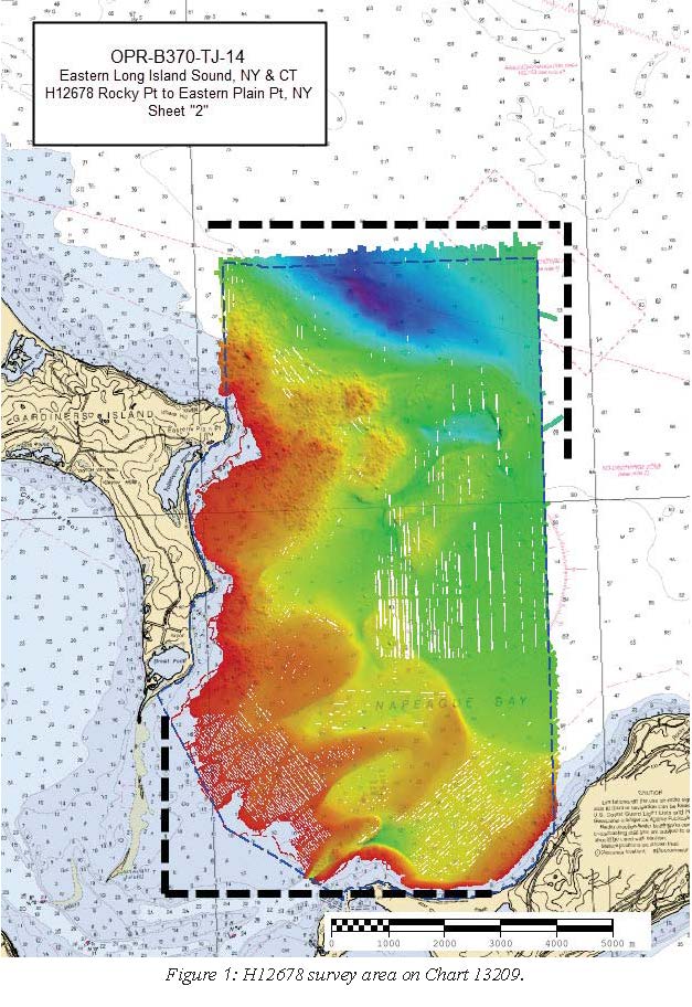
H12678: NOS Hydrographic Survey , 2014-10-23
National Oceanic and Atmospheric Administration, Department of Commerce —
The National Oceanic and Atmospheric Administration (NOAA) has the statutory mandate to collect hydrographic data in support of nautical chart compilation for safe... -
Federal
Surfrider, station 1174
National Oceanic and Atmospheric Administration, Department of Commerce —
Fecal indicator bacteria levels are measured in water samples collected from ocean and bay beaches, streams, lakes and other coastal waterways. Water samples are... -
Federal
E01 Met - Meteorology
National Oceanic and Atmospheric Administration, Department of Commerce —
Ocean observation data from the Northeastern Regional Association of Coastal & Ocean Observing Systems (NERACOOS). The NERACOOS region includes the northeast... -
Federal
Oceanographic data collected from non-federal stations assembled by the Great Lakes Observing System (GLOS)
National Oceanic and Atmospheric Administration, Department of Commerce —
This dataset contains oceanographic and surface meteorological data collected from non-Federal stations throughout the Great Lakes region of the United States. The... -
Federal
NOAA/WDS Paleoclimatology - Cook et al. 2008 North American Drought Atlas Version 2a
National Oceanic and Atmospheric Administration, Department of Commerce —
This archived Paleoclimatology Study is available from the NOAA National Centers for Environmental Information (NCEI), under the World Data Service (WDS) for...

Official websites use .gov
A
.gov website belongs to an official government
organization in the United States.
Secure .gov websites use HTTPS
A
lock (
) or https:// means you’ve safely connected to
the .gov website. Share sensitive information only on official,
secure websites.