
-
County
Redlining Maps from the Home Owners Loan Corporation, 1937
Allegheny County / City of Pittsburgh / Western PA Regional Data Center —
Most of the text in this description originally appeared on the Mapping Inequality Website. Robert K. Nelson, LaDale Winling, Richard Marciano, Nathan Connolly, et... -
Federal
Utah FORGE 3-2417: Low Frequency Distributed Acoustic Sensing Data from 16A/16B Stimulation - April, 2024
Department of Energy —
This dataset contains processed low-frequency Distributed Acoustic Sensing (LF-DAS) data collected between April 2 and April 12, 2024, during the Utah FORGE... -
Federal
Process-structure-properties investigations for laser powder bed fused IN718 in the as-built condition
National Institute of Standards and Technology —
This data repository provides a central location for a body of work using one build of nickel-based alloy 718 (IN718) material and resulted in three different... -
Federal
Gridded Population of the World, Version 4 (GPWv4): Population Density, Revision 11
National Aeronautics and Space Administration —
The Gridded Population of the World, Version 4 (GPWv4): Population Density, Revision 11 consists of estimates of human population density (number of persons per... -
Federal
Data from: Genotypic characterization of the U.S. peanut core collection
Department of Agriculture —
This collection contains supplementary data for the manuscript "Genotypic characterization of the U.S. Peanut Core Collection", which describes genotyping results for... -
Federal
Soil erosion and organic matter for central Great Plains cropping systems under residue removal
Department of Agriculture —
This study examined average annual changes in soil erosion from rainfall and wind forces, and trends in soil organic carbon (SOC). The diversity of geo-climatic land... -
Federal
Global Pesticide Grids (PEST-CHEMGRIDS), Version 1.01
National Aeronautics and Space Administration —
The Global Pesticide Grids (PEST-CHEMGRIDS), Version 1.01 data set contains 20 of the most-used pesticide active ingredients on 6 dominant crops and 4 aggregated crop... -
Federal
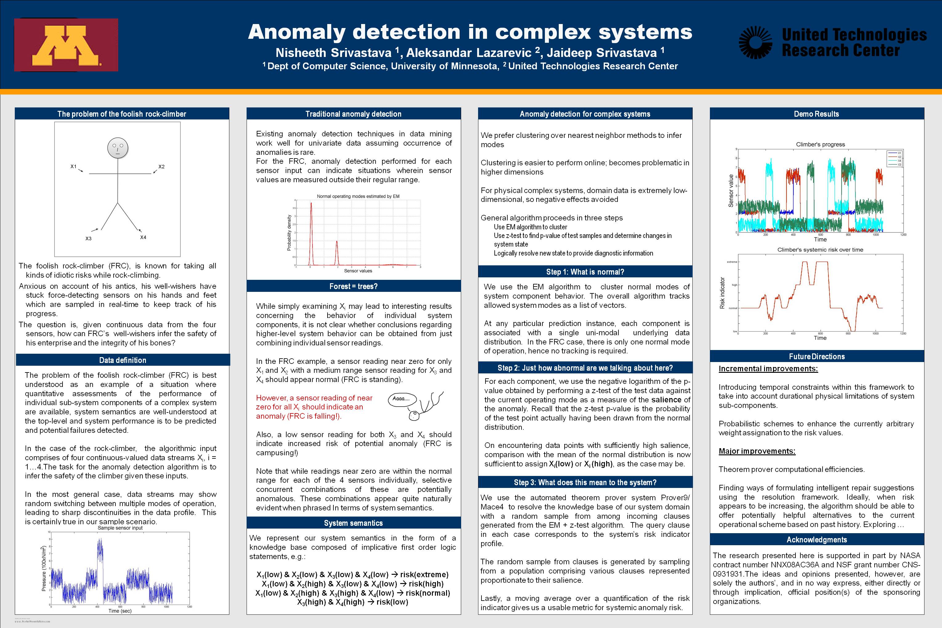
Anomaly Detection for Complex Systems
National Aeronautics and Space Administration —
In performance maintenance in large, complex systems, sensor information from sub-components tends to be readily available, and can be used to make predictions about... -
Federal
Global Fire Emissions Indicators, Country-Level Tabular Data: 1997-2015
National Aeronautics and Space Administration —
The Global Fire Emissions Indicators, Country-Level Tabular Data: 1997-2015 contains country tabulations from 1997 to 2015 for the total area burned (hectares) and... -
Federal
Pantropical Forest Height and Biomass from GEDI and TanDEM-X Data Fusion
National Aeronautics and Space Administration —
This dataset includes maps of canopy height and aboveground biomass at spatial resolutions of 25 m and 100 m for Mexico, Gabon, French Guiana, and the Amazon Basin.... -
Federal
H12305: NOS Hydrographic Survey , Central Chesapeake Bay, 2013-12-10
National Oceanic and Atmospheric Administration, Department of Commerce —
The National Oceanic and Atmospheric Administration (NOAA) has the statutory mandate to collect hydrographic data in support of nautical chart compilation for safe... -
Federal
Food Insecurity Hotspots Data Set
National Aeronautics and Space Administration —
The Food Insecurity Hotspots Data Set consists of grids at 250 meter (~7.2 arc-seconds) resolution that identify the level of intensity and frequency of food... -
Federal
GOES-R PLT Airborne Visible/Infrared Imaging Spectrometer (AVIRIS) V1
National Aeronautics and Space Administration —
The GOES-R PLT Airborne Visible/Infrared Imaging Spectrometer (AVIRIS) dataset consists of radiance, reflectance, water phase, and navigation data delivered by the... -
Federal
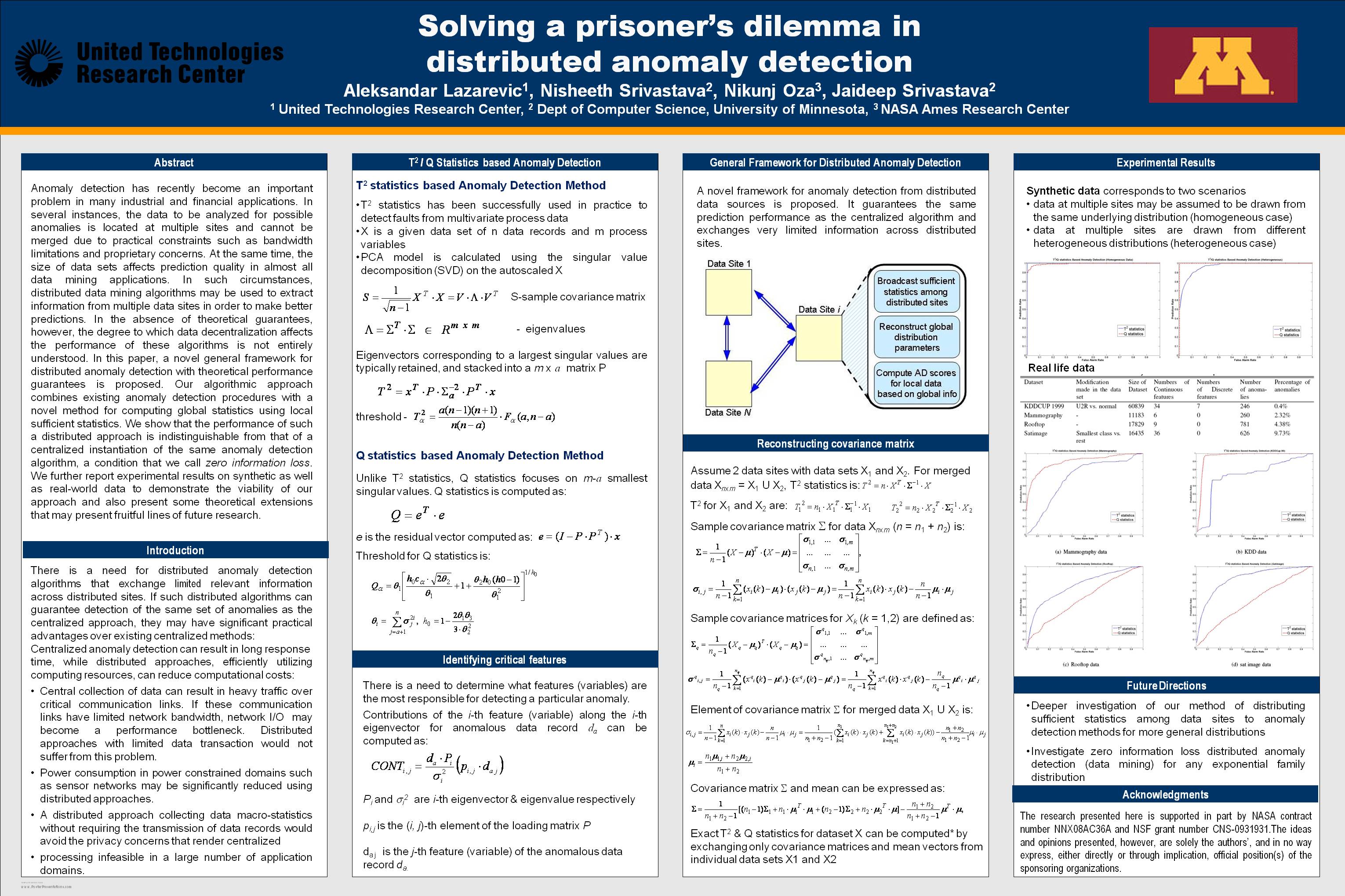
Solving a prisoner's dilemma in distributed anomaly detection
National Aeronautics and Space Administration —
Anomaly detection has recently become an important problem in many industrial and financial applications. In several instances, the data to be analyzed for possible... -
Federal
Newberry EGS Demonstration: Well 55-29 Stimulation Data
Department of Energy —
The Newberry Volcano EGS Demonstration in central Oregon, a 3 year project started in 2010, tests recent technological advances designed to reduce the cost of power... -
Federal
Data and Code from: Smart vision-based monitoring system for AI-driven moth population estimation using camera-equipped trap imaging
Department of Agriculture —
Real-time, image-based monitoring for stored product insect pests could increase timely treatments and protection for postharvest products throughout the supply... -
Federal
Millennium Ecosystem Assessment: MA Ecosystems
National Aeronautics and Space Administration —
The Millennium Ecosystem Assessment: MA Ecosystems provides data and information on the extent and classification of ecosystems circa 2000, including coastal,... -
Federal
CYGNSS Level 3 MRG Science Data Record Version 3.2
National Aeronautics and Space Administration —
This dataset contains the version 3.2 CYGNSS level 3 science data record merged storm (MRG) wind speed which combines CYGNSS storm-centric gridded (SCG) wind speeds,... -
Federal
Aquarius Official Release Level 3 Wind Speed Standard Mapped Image Ascending Seasonal Climatology Data V5.0
National Aeronautics and Space Administration —
Aquarius Level 3 ocean surface wind speed standard mapped image data contains gridded 1 degree spatial resolution wind speed data averaged over daily, 7 day, monthly,... -
Federal
ABoVE: Wetland Vegetation Classification for Peace-Athabasca Delta, Canada, 2019
National Aeronautics and Space Administration —
This dataset contains land cover classification focused on water and wetland vegetation communities over the Peace-Athabasca Delta, Canada. Four classification maps...

Official websites use .gov
A
.gov website belongs to an official government
organization in the United States.
Secure .gov websites use HTTPS
A
lock (
) or https:// means you’ve safely connected to
the .gov website. Share sensitive information only on official,
secure websites.