
-
Federal
Lightering Zones recent views
National Oceanic and Atmospheric Administration, Department of Commerce —
These data represent federal and state lightering zones within U.S. waters. Lightering is the transfer of a cargo of oil in bulk from one oil tanker less than 150... -
Federal
Near-Real Time Surface Ocean Velocity, Hawaii, 6 km Resolution recent views
National Oceanic and Atmospheric Administration, Department of Commerce —
Surface ocean velocities estimated from HF-Radar (HFR) are representative of the upper 0.3 - 2.5 meters of the ocean. The main objective of near-real time processing... -
Federal
Offshore Oil and Gas Platforms recent views
National Oceanic and Atmospheric Administration, Department of Commerce —
These data show the location for oil and gas platforms located in the state and federal waters of the United States. Generally, this data set does not show platforms... -
Federal
Shoreline Mapping Program of HEAD OF GREEN BAY TO PESHTIGO POINT, INCLUDING FOX RIVER TO DE PERE, WI, WI1001G-CM-N NGDA recent views
National Oceanic and Atmospheric Administration, Department of Commerce —
These data provide an accurate high-resolution shoreline compiled from imagery of HEAD OF GREEN BAY TO PESHTIGO POINT, INCLUDING FOX RIVER TO DE PERE, WI . This... -
Federal
NOAA/WDS Paleoclimatology - Swetnam - Indian Creek - PIPO - ITRDB CO528 recent views
National Oceanic and Atmospheric Administration, Department of Commerce —
This archived Paleoclimatology Study is available from the NOAA National Centers for Environmental Information (NCEI), under the World Data Service (WDS) for... -
Federal
NOAA/WDS Paleoclimatology - Earle - San Juan Hill - PSME - ITRDB WA090 recent views
National Oceanic and Atmospheric Administration, Department of Commerce —
This archived Paleoclimatology Study is available from the NOAA National Centers for Environmental Information (NCEI), under the World Data Service (WDS) for... -
Federal
NOAA/WDS Paleoclimatology - Grissino-Mayer fire data from La Marchanita - IMPD USLAM001 recent views
National Oceanic and Atmospheric Administration, Department of Commerce —
This archived Paleoclimatology Study is available from the NOAA National Centers for Environmental Information (NCEI), under the World Data Service (WDS) for... -
Federal
H10749A: NOS Hydrographic Survey , Approaches to Port Everglades, Florida, 1998-06-10 recent views
National Oceanic and Atmospheric Administration, Department of Commerce —
The National Oceanic and Atmospheric Administration (NOAA) has the statutory mandate to collect hydrographic data in support of nautical chart compilation for safe... -
Federal
NOAA/WDS Paleoclimatology - Graybill - San Francisco Peaks A - PIAR - ITRDB AZ510 recent views
National Oceanic and Atmospheric Administration, Department of Commerce —
This archived Paleoclimatology Study is available from the NOAA National Centers for Environmental Information (NCEI), under the World Data Service (WDS) for... -
Federal
NOAA/WDS Paleoclimatology - King - Kuna Crest Yosemite National National Park - PICO - ITRDB CA580 recent views
National Oceanic and Atmospheric Administration, Department of Commerce —
This archived Paleoclimatology Study is available from the NOAA National Centers for Environmental Information (NCEI), under the World Data Service (WDS) for... -
Federal
NOAA/WDS Paleoclimatology - Peterson - Hart's Pass N2 - PCEN - ITRDB WA074 recent views
National Oceanic and Atmospheric Administration, Department of Commerce —
This archived Paleoclimatology Study is available from the NOAA National Centers for Environmental Information (NCEI), under the World Data Service (WDS) for... -
Federal
NOAA/WDS Paleoclimatology - Dean - Burning Bridge Wash - PIED - ITRDB NM053 recent views
National Oceanic and Atmospheric Administration, Department of Commerce —
This archived Paleoclimatology Study is available from the NOAA National Centers for Environmental Information (NCEI), under the World Data Service (WDS) for... -
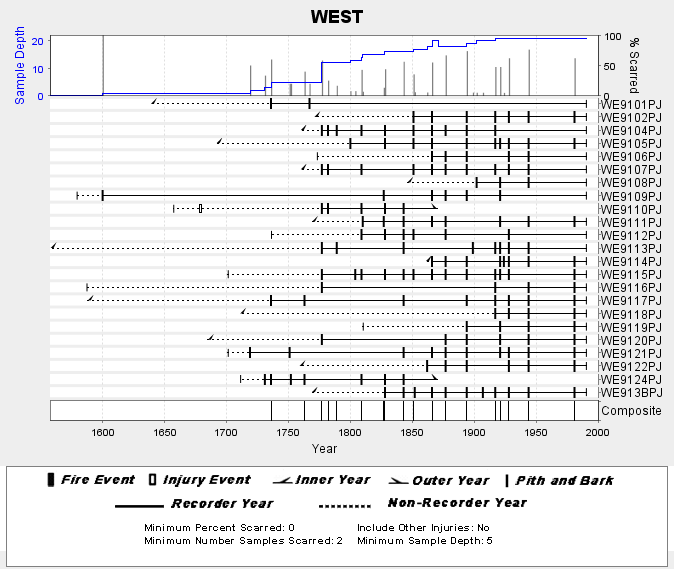
Federal
NOAA/WDS Paleoclimatology - Skinner fire data from WEST (San Pedro Martir) - IMPD MXWES001 recent views
National Oceanic and Atmospheric Administration, Department of Commerce —
This archived Paleoclimatology Study is available from the NOAA National Centers for Environmental Information (NCEI), under the World Data Service (WDS) for... -
Federal
NOAA/WDS Paleoclimatology - King - Gin Flat Yosemite National Park - PILA - ITRDB CA575 recent views
National Oceanic and Atmospheric Administration, Department of Commerce —
This archived Paleoclimatology Study is available from the NOAA National Centers for Environmental Information (NCEI), under the World Data Service (WDS) for... -
Federal
NOAA/WDS Paleoclimatology - Stahle - Nottoway River - TADI - ITRDB VA025 recent views
National Oceanic and Atmospheric Administration, Department of Commerce —
This archived Paleoclimatology Study is available from the NOAA National Centers for Environmental Information (NCEI), under the World Data Service (WDS) for... -
Federal
NOAA/WDS Paleoclimatology - Duvick - Current River Natural Area - QUAL - ITRDB MO001 recent views
National Oceanic and Atmospheric Administration, Department of Commerce —
This archived Paleoclimatology Study is available from the NOAA National Centers for Environmental Information (NCEI), under the World Data Service (WDS) for... -
Federal
Shoreline Mapping Program of Little Hickory Island to Doctors Pass, FL, FL1601C-CM-N NGDA recent views
National Oceanic and Atmospheric Administration, Department of Commerce —
These data provide an accurate high-resolution shoreline compiled from imagery of Little Hickory Island to Doctors Pass, FL . This vector shoreline data is based on... -
Federal
Shoreline Data Rescue Project of Everglades City to Venice, CM-7808 NGDA recent views
National Oceanic and Atmospheric Administration, Department of Commerce —
These data were automated to provide an accurate high-resolution historical shoreline of Everglades City to Venice suitable as a geographic information system (GIS)... -
Federal
Shoreline Mapping Program of Intracoastal Waterway, Dollar Bay to Johnson Bay, FL, FL1601D-CM-N NGDA recent views
National Oceanic and Atmospheric Administration, Department of Commerce —
These data provide an accurate high-resolution shoreline compiled from imagery of Intracoastal Waterway, Dollar Bay to Johnson Bay, FL . This vector shoreline data is... -
Federal
Papahanaumokuakea Marine National Monument (PMNM) Outline - Northwestern Hawaiian Islands (NWHI) recent views
National Oceanic and Atmospheric Administration, Department of Commerce —
Boundary of the Papahanaumokuakea Marine National Monument (PMNM), located in the Northwestern Hawaiian Islands (NWHI). Created in 2006, Papahanaumokuakea is the...

Official websites use .gov
A
.gov website belongs to an official government
organization in the United States.
Secure .gov websites use HTTPS
A
lock (
) or https:// means you’ve safely connected to
the .gov website. Share sensitive information only on official,
secure websites.