
-
Federal
GLDAS Catchment Land Surface Model L4 daily 0.25 x 0.25 degree GRACE-DA1 V2.2 (GLDAS_CLSM025_DA1_D) at GES DISC recent views
National Aeronautics and Space Administration —
NASA Global Land Data Assimilation System Version 2 (GLDAS-2) has three components: GLDAS-2.0, GLDAS-2.1, and GLDAS-2.2. GLDAS-2.0 is forced entirely with the... -
Federal
SMEX02 SMACEX Tower Meteorological/Flux Data: Iowa, Version 1 recent views
National Aeronautics and Space Administration —
Notice to Data Users: The documentation for this data set was provided solely by the Principal Investigator(s) and was not further developed, thoroughly reviewed, or... -
Federal
CERES Monthly Gridded Radiative Fluxes and Clouds Terra FM1 Edition2F recent views
National Aeronautics and Space Administration —
CER_FSW_Terra-FM1-MODIS_Edition2F is the Clouds and the Earth's Radiant Energy System (CERES) Monthly Gridded Radiative Fluxes and Clouds Terra Flight Model 1 (FM1)... -
Federal
Aircraft Scanners recent views
National Aeronautics and Space Administration —
The National Aeronautics and Space Administration (NASA) Aircraft Scanners data set contains digital imagery acquired from several multispectral scanners, including... -
Federal
Earth Radiation Budget Experiment (ERBE) S-10 Medium Field of View (MFOV) Shape Factor (SF) Radiant Flux and Albedo recent views
National Aeronautics and Space Administration —
ERBE_S10_MFOV_SF_NAT_1 is the Earth Radiation Budget Experiment (ERBE) S-10 Medium Field of View (MFOV) Shape Factor (SF) Radiant Flux and Albedo data product. Data... -
Federal
Sentinel-3B OLCI Level-3B Global Binned Earth-observation Reduced Resolution (ERR) Remote-Sensing Reflectance (RRS) - Near Real-time (NRT) Data, version R2022.0 recent views
National Aeronautics and Space Administration —
The Ocean Biology DAAC produces near real-time (quicklook) products using the best-available combination of ancillary data from meteorological and ozone data. As... -
Federal
MISR Level 2 Surface parameters V002 recent views
National Aeronautics and Space Administration —
MIL2ASLS_2 is the Multi-angle Imaging SpectroRadiometer (MISR) Level 2 Land Surface parameters version 2 data product. It contains a variety of information on the... -
Federal
MISR Level 3 Component Global Land Product covering a year V004 recent views
National Aeronautics and Space Administration —
MIL3YLS_4 is the Multi-angle Imaging SpectroRadiometer (MISR) Level 3 Component Global Land Product covering a year version 4. It contains a statistical summary of... -
Federal
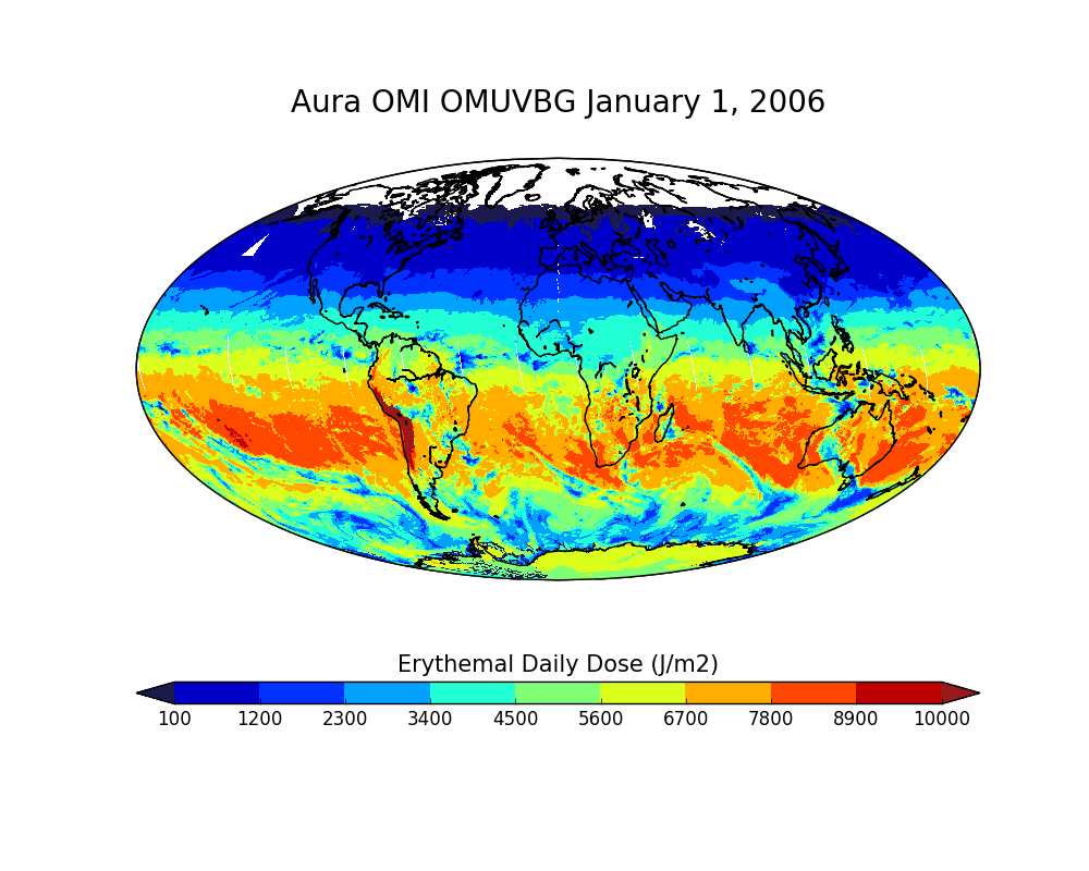
OMI/Aura Surface UVB Irradiance and Erythemal Dose Daily L2 Global Gridded 0.25 degree x 0.25 degree V3 (OMUVBG) at GES DISC recent views
National Aeronautics and Space Administration —
This is Level-2G daily global gridded Aura-OMI Spectral Surface UVB Irradiance and Erythemal Dose product (OMUVBG). The OMUVBG is a special Level-2 Global Gridded... -
Federal
MODIS/Terra Clear Sky Radiance 8-Day Composite Daily L3 Global 25km Equal Area NGDA recent views
National Aeronautics and Space Administration —
The MODIS/Terra Clear Sky Radiance 8-Day Composite Daily L3 Global 25km Equal Area (MODCSR_8) product is created from composited MODCSR_D files. Nine clear-sky... -
Federal
MERRA-2 tavgM_2d_rad_Nx: 2d,Monthly mean,Time-Averaged,Single-Level,Assimilation,Radiation Diagnostics 0.625 x 0.5 degree V5.12.4 (M2TMNXRAD) at GES DISC recent views
National Aeronautics and Space Administration —
M2TMNXRAD (or tavgM_2d_rad_Nx) is a time-averaged 2-dimensional monthly mean data collection in Modern-Era Retrospective analysis for Research and Applications... -
Federal
Land Surface Model (LSM 1.0) for Ecological, Hydrological, Atmospheric Studies recent views
National Aeronautics and Space Administration —
The NCAR LSM 1.0 is a land surface model developed to examine biogeophysical and biogeochemical land-atmosphere interactions, especially the effects of land surfaces... -
Federal
GLDAS Catchment Land Surface Model L4 daily 0.25 x 0.25 degree GRACE-DA1 V2.2 (GLDAS_CLSM025_DA1_D_EP) at GES DISC recent views
National Aeronautics and Space Administration —
NASA Global Land Data Assimilation System Version 2 (GLDAS-2) has three components: GLDAS-2.0, GLDAS-2.1, and GLDAS-2.2. GLDAS-2.0 is forced entirely with the... -
Federal
GLDAS VIC Land Surface Model L4 3 hourly 1.0 x 1.0 degree V2.1 (GLDAS_VIC10_3H) at GES DISC recent views
National Aeronautics and Space Administration —
NASA Global Land Data Assimilation System Version 2 (GLDAS-2) has three components: GLDAS-2.0, GLDAS-2.1, and GLDAS-2.2. GLDAS-2.0 is forced entirely with the... -
Federal
CALIPSO Lidar Level 2 Blowing Snow - Antarctica, V1-01 recent views
National Aeronautics and Space Administration —
CAL_LID_L2_BlowingSnow_Antarctica-Standard-V1-01 is the Cloud-Aerosol Lidar and Infrared Pathfinder Satellite Observations (CALIPSO) Lidar Level 2 Blowing Snow -... -
Federal
Sentinel-3B OLCI Level-2 Earth-observation Reduced Resolution (ERR) Ocean Color (OC) - Near Real-time (NRT) Data, version R2022.0 recent views
National Aeronautics and Space Administration —
The Ocean Biology DAAC produces near real-time (quicklook) products using the best-available combination of ancillary data from meteorological and ozone data. As... -
Federal
Sentinel-3B OLCI Level-3B Global Binned Earth-observation Reduced Resolution (ERR) Chlorophyll (CHL) Data, version R2022.0 recent views
National Aeronautics and Space Administration —
The Ocean and Land Colour Instrument (OLCI) is the successor to ENVISAT's Medium Resolution Imaging Spectrometer (MERIS) having additional spectral channels,... -
Federal
Sentinel-3A OLCI Level-3M Global Mapped Earth-observation Reduced Resolution (ERR) Chlorophyll (CHL) Data, version R2022.0 recent views
National Aeronautics and Space Administration —
The Ocean and Land Colour Instrument (OLCI) is the successor to ENVISAT's Medium Resolution Imaging Spectrometer (MERIS) having additional spectral channels,... -
Federal
GEWEX SRB Integrated Product (Rel-4) Longwave Monthly Average by UTC Ocean-only Fluxes recent views
National Aeronautics and Space Administration —
GEWEXSRB_Rel4-IP_Longwave_monthly_oceanonly_utc is the Global Energy and Water Exchanges (GEWEX) Surface Radiation Budget (SRB) Integrated Product (Rel-4) Longwave... -
Federal
GLDAS Catchment Land Surface Model L4 monthly 1.0 x 1.0 degree V2.0 (GLDAS_CLSM10_M) at GES DISC recent views
National Aeronautics and Space Administration —
NASA Global Land Data Assimilation System Version 2 (GLDAS-2) has three components: GLDAS-2.0, GLDAS-2.1, and GLDAS-2.2. GLDAS-2.0 is forced entirely with the...

Official websites use .gov
A
.gov website belongs to an official government
organization in the United States.
Secure .gov websites use HTTPS
A
lock (
) or https:// means you’ve safely connected to
the .gov website. Share sensitive information only on official,
secure websites.