
-
Federal
National Oceanic and Atmospheric Administration (NOAA) recent views
National Aeronautics and Space Administration —
NOAA measurements from 1996 to 1999 along the Eastern US coastal region. -
Federal
Suomi-NPP VIIRS Regional 11µm Day/Night Sea Surface Temperature (SST) Data, version 2016.2 recent views
National Aeronautics and Space Administration —
The Visible and Infrared Imager/Radiometer Suite (VIIRS) is a multi-disciplinary instrument that is being flown on the Joint Polar Satellite System (JPSS) series of... -
Federal
Northwest Pacific Pre-SWOT Level-4 Hourly MITgcm LLC4320 Native Grid 2km Oceanographic Dataset Version 1.0 recent views
National Aeronautics and Space Administration —
This dataset provides a regional multivariate oceanographic state estimate from a global ocean numerical simulation with a focus on the Northwest Pacific Ocean... -
Federal
TARA-EUROPA recent views
National Aeronautics and Space Administration —
For two consecutive years (2023-2024), the schooner Tara is participating in the study of coastal ecosystems all along the European coast. The sampling of Tara Europa... -
Federal
Measurements in the Arctic north of Alaska during 2000 recent views
National Aeronautics and Space Administration —
Measurements from the Beaufort and Chukchi seas in the Arctic north of Alaska during 2000. -
Federal
Suomi-NPP VIIRS Regional Triple-window Sea Surface Temperature (SST3) Data, version 2016.2 recent views
National Aeronautics and Space Administration —
The Visible and Infrared Imager/Radiometer Suite (VIIRS) is a multi-disciplinary instrument that is being flown on the Joint Polar Satellite System (JPSS) series of... -
Federal
Suomi-NPP VIIRS Global Binned Triple-window Sea Surface Temperature (SST3) Data, version 2016.2 recent views
National Aeronautics and Space Administration —
The Visible and Infrared Imager/Radiometer Suite (VIIRS) is a multi-disciplinary instrument that is being flown on the Joint Polar Satellite System (JPSS) series of... -
Federal
Littoral Warfare Advanced Development (LWAD) Program 2001-2002 recent views
National Aeronautics and Space Administration —
Measurements taken under the Office of Naval Reaserch (ONR) Littoral Warfare Advanced Development (LWAD) Program along the East China Sea during 2001 -
Federal
Sounder SIPS: Suomi NPP CrIMSS Level 3 Specific Quality Control Gridded Daily SiFSAP V2 (SNDRSNIML3SDSFSP) at GES DISC recent views
National Aeronautics and Space Administration —
The SIFSAP (Single Field-of-View Sounder Atmospheric Products) algorithm provides retrieval for each sounder Field of View (FOV), therefore, it has 3-times higher... -
Federal
CTD (conductivity-temperature-depth) data collected on Stellwagen Bank during U.S. Geological Survey field activity 2017-043-FA, aboard the R/V Auk, Aug. 22 and 23, 2017 recent views
Department of the Interior —
This field activity is part of an effort to map geologic substrates of the Stellwagen Bank National Marine Sanctuary region off Boston, Massachusetts. The overall... -
Federal
Waveglider data for the SPURS-1 N. Atlantic field campaign recent views
National Aeronautics and Space Administration —
The SPURS (Salinity Processes in the Upper Ocean Regional Study) project is an oceanographic process study and associated field program that aim to elucidate key... -
Federal
Sounder SIPS: JPSS-1 CrIS Level 3 Specific Quality Control Gridded Monthly CLIMCAPS V2 (SNDRJ1IML3SMCCP) at GES DISC recent views
National Aeronautics and Space Administration —
WARNING: To users of the derived product “co_mmr_midtrop” (carbon monoxide mass mixing ratio to dry air [kg/kg] at ~500 hPa). This variable has a significant bias due... -
Federal
GHRSST Level 2P Global Subskin Sea Surface Temperature version 8.2 (v8.2) from the Advanced Microwave Scanning Radiometer 2 (AMSR2) by REMSS recent views
National Aeronautics and Space Administration —
This product provides a “Final” (Refined) Level-2 Sea Surface Temperature (SST) (currently identified by "v8.2" within the file name) for the Group for High... -
Federal
GHRSST NOAA/STAR GOES-17 ABI L2P America Region SST v2.71 dataset in GDS2 recent views
National Aeronautics and Space Administration —
GOES-17 (G17) is the second satellite in the US NOAA's GOES-R series. It was launched on 1 Mar 2018 in an interim position at 89.5-deg W for initial Cal/Val, moved to... -
Federal
Sounder SIPS: Suomi NPP CrIMSS Level 3 Specific Quality Control Gridded Monthly CHART Normal Spectral Resolution V1 recent views
National Aeronautics and Space Administration —
The objective of this limited edition data collection is to examine products generated by the Climate Heritage AIRS Retrieval Technique (CHART) algorithm to analyze... -
Federal
Sounder SIPS: JPSS-1 CrIS Level 3 Comprehensive Quality Control Gridded Daily CLIMCAPS V2 (SNDRJ1IML3CDCCP) at GES DISC recent views
National Aeronautics and Space Administration —
WARNING: To users of the derived product “co_mmr_midtrop” (carbon monoxide mass mixing ratio to dry air [kg/kg] at ~500 hPa). This variable has a significant bias due... -
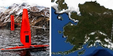
Federal
Saildrone 2022 Arctic field campaign for the Multi-Sensor Improved SST (MISST) project recent views
National Aeronautics and Space Administration —
Saildrone is a wind and solar powered unmanned surface vehicle (USV) capable of long distance deployments lasting up to 12 months and providing high quality, near... -
Federal
Measurements made near Long Island recent views
National Aeronautics and Space Administration —
Measurements made near Long Island, New York between 2004 and 2009. -
Federal
Terra MODIS Global Binned 11µm Nighttime Sea Surface Temperature (NSST) Data, version R2019.0 NGDA recent views
National Aeronautics and Space Administration —
MODIS (or Moderate Resolution Imaging Spectroradiometer) is a key instrument aboard the Terra (EOS AM) and Aqua (EOS PM) satellites. Terra's orbit around the Earth is... -
Federal
Measurements near Nauru, Micronesia in 1999 recent views
National Aeronautics and Space Administration —
Measurements made around the island of Nauru in Micronesia in 1999.

Official websites use .gov
A
.gov website belongs to an official government
organization in the United States.
Secure .gov websites use HTTPS
A
lock (
) or https:// means you’ve safely connected to
the .gov website. Share sensitive information only on official,
secure websites.