

11 datasets found for "易优eyoucms|美妆美甲医学美容医院类网站模板627✅项目合作 二开均可 TG:saolei44✅.kQUiIdfxPuleNl"
-
Federal
Delta-X: Delft3D Sediment Model, Site 322, Terrebonne Basin, MRD, Louisiana, USA
National Aeronautics and Space Administration —
This dataset contains the Delft3D model of the intensive site 322 in the Terrebonne Basin along the Mississippi River Delta (MRD) in coastal Louisiana. Simulations... -
Federal
VIIRS/JPSS1 Land Surface Temperature/Emissivity 8-Day L3 Global 0.05Deg CMG V002
National Aeronautics and Space Administration —
The NOAA-20 Visible Infrared Imaging Radiometer Suite (VIIRS) Land Surface Temperature and Emissivity (LST&E) 8-day Climate Modeling Grid Version 2 product... -
Federal
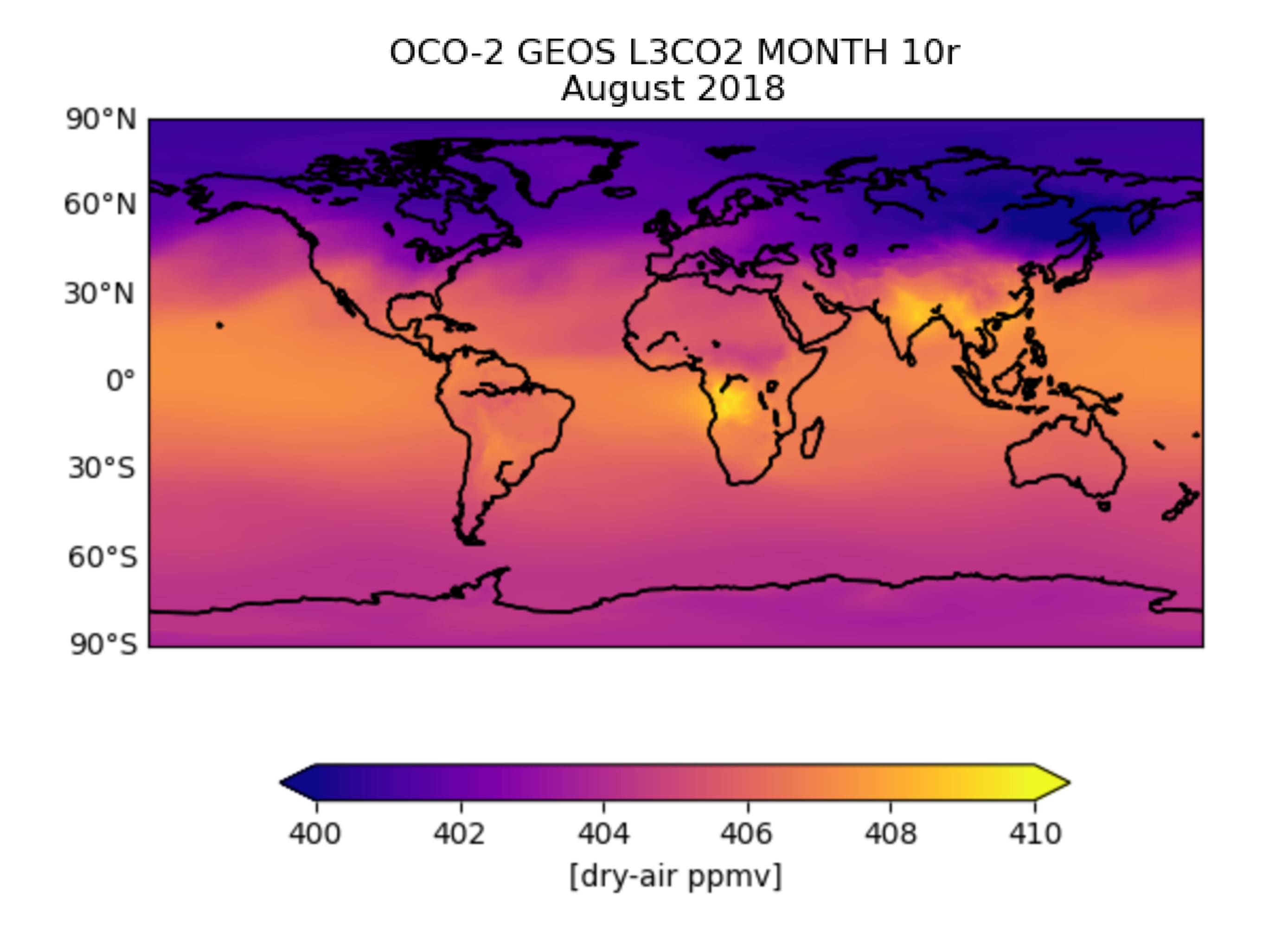
OCO-2 GEOS Level 3 monthly, 0.5x0.625 assimilated CO2 V10r (OCO2_GEOS_L3CO2_MONTH) at GES DISC
National Aeronautics and Space Administration —
This is the Gridded Monthly OCO-2 Carbon Dioxide assimilated dataset. The OCO-2 mission provides the highest quality space-based XCO2 retrievals to date. However, the... -
Federal
Combined ASTER and MODIS Emissivity database over Land (CAMEL) Uncertainty Monthly Global 0.05Deg V003
National Aeronautics and Space Administration —
The NASA Making Earth System Data Records for Use in Research Environments (MEaSUREs) Combined Advanced Spaceborne Thermal Emission and Reflection Radiometer (ASTER)... -
Federal
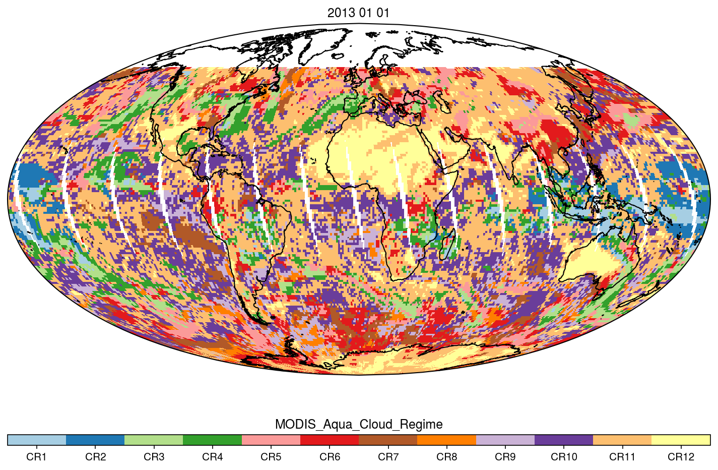
MODIS_CR_Equal_Angle_Daily
National Aeronautics and Space Administration —
The MODIS Collection 6.1 Equal-Angle Three-Hourly Cloud Regime product. This product is a discrete classification of cloud fields at the mesoscale as observed by the... -
Federal
SAFARI 2000 Land Cover from AVHRR, 1-km, 1992-1993 (Hansen et al.)
National Aeronautics and Space Administration —
The data set consists of a southern African subset of the 1-km Global Land Cover Data Set Derived from AVHRR developed at the Laboratory for Global Remote Sensing... -
Federal
NASA Global Web-Enabled Landsat Data Annual Global 30 m V032
National Aeronautics and Space Administration —
The NASA Making Earth System Data Records for Use in Research Environments (MEaSUREs) Global Web-Enabled Landsat Data Annual (GWELDYR) Version 3.2 data product... -
Federal
GOES-R PLT Colorado Lightning Mapping Array (LMA)
National Aeronautics and Space Administration —
The GOES-R PLT Colorado Lightning Mapping Array (LMA) dataset consists of total lightning data measured from the Colorado LMA (COLMA) network during the GOES-R Post... -
Federal
ECCO Ocean 3D Gent-Mcwilliams, Redi, and Background Vertical Diffusivity Coefficients for the 0.5 degree Lat-Lon Model Grid (Version 4 Release 4)
National Aeronautics and Space Administration —
This dataset provides 3D coefficients for the Gent-McWilliams and Redi parameterizations and background vertical diffusivity interpolated to a regular 0.5-degree grid... -
Federal
HSFA2 functions in the physiological adaptation of undifferentiated plant cells to spaceflight microgravity environment
National Aeronautics and Space Administration —
The Heat Shock Factor A2 (HsfA2), as a part of the HSF network, is essential to the plant's response to almost any environmental stress and to the cellular... -
Federal
Transcriptional profiling of livers from mice flown on Rodent Research Reference Mission-1 (RRRM-1)
National Aeronautics and Space Administration —
In the Rodent Research Reference Mission (RRRM-1), forty female BALB/cAnNTac mice were flown on the International Space Station. To assess differences in outcomes due...
11 datasets found for "易优eyoucms|美妆美甲医学美容医院类网站模板627✅项目合作 二开均可 TG:saolei44✅.kQUiIdfxPuleNl"