
-
Federal
precisionFDA Truth Challenge V2: Calling variants from short- and long-reads in difficult-to-map regions
Department of Commerce —
The precisionFDA Truth Challenge V2 aimed to assess the state-of-the-art of variant calling in difficult-to-map regions and the Major Histocompatibility Complex... -
Federal
LBA-ECO TG-05 NPP, Carbon Pool, Soil Characteristics, Soil Gas Flux Maps of Brazil
National Aeronautics and Space Administration —
This data set provides maps produced from model output data from the National Aeronautics and Space Administration-Carnegie Ames Stanford Approach (NASA-CASA) model... -
Federal
LBA-ECO TG-07 Soil Trace Gas Fluxes km 67 Seca-Floresta Site, Tapajos National Forest
National Aeronautics and Space Administration —
Trace gas fluxes of carbon dioxide, methane, nitrous oxide, and nitric oxide (CO2, CH4, N2O, and NO) from surface soil were measured manually in an undisturbed forest... -
Federal
GPM SSMIS on F18 (GPROF) Climate-based Radiometer Precipitation Profiling L3 1 month 0.25 degree x 0.25 degree V07 (GPM_3GPROFF18SSMIS_CLIM) at GES DISC
National Aeronautics and Space Administration —
Version 07 is the current version of the data set. Older versions will no longer be available and have been superseded by Version 07. The "CLIM" products differ from... -
Federal
precisionFDA Truth Challenge V2: Calling variants from short- and long-reads in difficult-to-map regions
National Institute of Standards and Technology —
The precisionFDA Truth Challenge V2 aimed to assess the state-of-the-art of variant calling in difficult-to-map regions and the Major Histocompatibility Complex... -
Federal
DSCOVR EPIC Level 1B Version 3
National Aeronautics and Space Administration —
Deep Space Climate Observatory (DSCOVR) Earth Polychromatic Imaging Camera (EPIC) is a 10-channel spectro-radiometer (317 – 780 nm) onboard National Oceanic and... -
Federal
ASTER L2 Surface Reflectance VNIR and Crosstalk Corrected SWIR V003
National Aeronautics and Space Administration —
The Terra Advanced Spaceborne Thermal Emission and Reflection Radiometer (ASTER) Surface Reflectance VNIR and Crosstalk Corrected SWIR (AST_07XT) dataset contains... -
Federal
ASTER L2 Surface Radiance - VNIR and Crosstalk Corrected SWIR V003
National Aeronautics and Space Administration —
The Terra Advanced Spaceborne Thermal Emission and Reflection Radiometer (ASTER) Surface Radiance VNIR and Crosstalk Corrected SWIR (AST_09XT) is a multi-file product... -
Federal
NGC 6231 Chandra X-Ray Point Source Catalog 2
National Aeronautics and Space Administration —
NGC 6231 is a young cluster (age ~2-7 Myr) dominating the Sco OB1 association (distance ~1.59 kpc) with ~100 O and B stars and a large pre-main-sequence stellar... -
Federal
GPM Ground Validation TRMM Multi-satellite Precipitation Analysis (TMPA) IPHEx V7
National Aeronautics and Space Administration —
This GPM Ground Validation TRMM Multi-satellite Precipitation Analysis (TMPA) IPHEx dataset is a subset of the TMPA 3B42RT gridded precipitation product selected for... -
Federal
DSCOVR EPIC Level 1A Version 3
National Aeronautics and Space Administration —
Deep Space Climate Observatory (DSCOVR) Earth Polychromatic Imaging Camera (EPIC) is a 10-channel spectro-radiometer (317 – 780 nm) onboard the National Oceanic and... -
Federal
LBA-ECO TG-02 Biogenic VOC Emissions from Brazilian Amazon Forest and Pasture Sites
National Aeronautics and Space Administration —
This data set reports concentrations of biogenic volatile organic compounds (BVOCs) collected from tethered balloon-sampling platforms above selected forest and... -
Federal
GLAS/ICESat 1 km Laser Altimetry Digital Elevation Model of Greenland, Version 1
National Aeronautics and Space Administration —
The Geoscience Laser Altimeter System (GLAS) instrument on the Ice, Cloud, and land Elevation Satellite (ICESat) provides global measurements of elevation, and... -
Federal
STEREO-B/SECCHI/EUVI FITS data
National Aeronautics and Space Administration —
The Extreme Ultraviolet Imager (EUVI) is part of the Sun Earth Connection Coronal and Heliospheric Investigations (SECCHI) instrument suite on the NASA STEREO... -
Federal
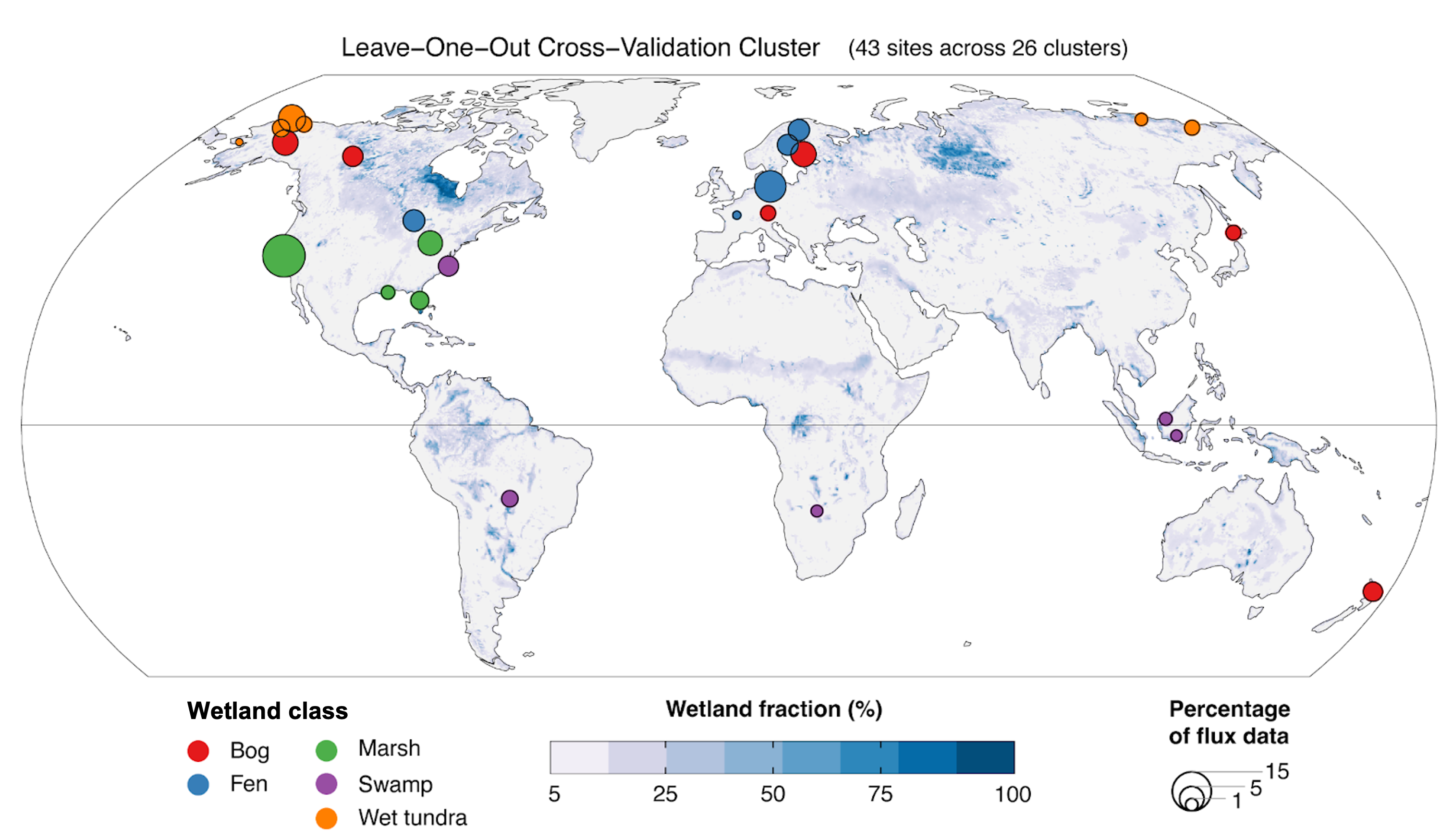
Global Wetland Methane Emissions derived from FLUXNET and the UpCH4 Model, 2001-2018
National Aeronautics and Space Administration —
This dataset provides monthly globally gridded freshwater wetland methane emissions from 2001-2018 in nmol CH4 m-2 s-1, g C-CH4 m-2 d-1, and TgCH4 grid cell-1... -
Federal
Reduced Resolution Geolocated and Calibrated TOA Radiance
National Aeronautics and Space Administration —
The Medium Resolution Imaging Spectrometer (MERIS) is one of 10 sensors deployed in March of 2002 on board the polar-orbiting Envisat-1 environmental research... -
Federal
LBA-ECO TG-03 Solar Surface Irradiance and PAR, Brazilian Amazon: 1999-2004
National Aeronautics and Space Administration —
This data set includes solar surface irradiance from Kipp and Zonen CM-21 pyranometers, both total unfiltered and filtered (RG695), and photosynthetically active... -
Federal
Wind Solar Wind Experiment (SWE) Thermal Plamsa Moments, Key Parameter (K0), 99 s Data
National Aeronautics and Space Administration —
Wind SWE Key Parameter data: proton density, thermal speed, flow velocity vectors, and spacecraft position vectors. Various versions differ slightly from each other.... -
Federal
LBA-ECO TG-08 Trace Gas Fluxes from Wetted Forest and Pasture Soils, Rondonia, Brazil
National Aeronautics and Space Administration —
This data set includes the results of measurements of the soil gas fluxes of nitric oxide (NO), nitrous oxide (N2O), and carbon dioxide (CO2), soil moisture, soil... -
Federal
LBA-ECO TG-08 Soil Gas Flux after Forest and Pasture Fertilization, Rondonia, Brazil
National Aeronautics and Space Administration —
This data set provides nitric oxide (NO), nitrous oxide (N2O), carbon dioxide (CO2) flux measurements, nitrogen (N) and phosphorus (P) pools, net N mineralization and...

Official websites use .gov
A
.gov website belongs to an official government
organization in the United States.
Secure .gov websites use HTTPS
A
lock (
) or https:// means you’ve safely connected to
the .gov website. Share sensitive information only on official,
secure websites.