
-
Federal
Linear Axis Testbed at IMS Center - Run-to-Failure Experiment 01
National Institute of Standards and Technology —
A linear axis testbed at the Center for Intelligent Maintenance Systems (IMS Center) at the University of Cincinnati was run to failure (the detection of backlash)... -
State
Percentage of Physically-fit Students (LGHC Indicator)
State of California —
This is a source dataset for a Let's Get Healthy California indicator at https://letsgethealthy.ca.gov/. Data originally from the California Department of Education... -
Federal
Supporting data for "Lee, S.D., Cherry, J., Safoutin, M., McDonald, J. et al. 2018. Modeling and Validation of 48 V Mild Hybrid Lithium-Ion Battery Pack. SAE 2018-01-0433" V1
U.S. Environmental Protection Agency —
The purpose of this work was to develop and validate a 48 V lithium-ion battery model for integration into EPA’s ALPHA vehicle simulation model and that can also be... -
Federal
Supporting data for "Lee, S., Cherry, J., Safoutin, M., Neam, A., McDonald, J., Newman, K. 2018. Modeling and Controls Development of 48 V Mild Hybrid Electric Vehicles. SAE 2018-01-0413" V1
U.S. Environmental Protection Agency —
The purpose of this work was to develop a 48 V mild hybrid electric vehicle (MHEV) model for drive cycle simulation using the EPA Advanced Light-Duty Powertrain and... -
Federal
1995 Average Monthly Sea Surface Temperature for California
National Oceanic and Atmospheric Administration, Department of Commerce —
The NOAA/ NASA AVHRR Oceans Pathfinder sea surface temperature data are derived from the 5-channel Advanced Very High Resolution Radiometers (AVHRR) on board the NOAA... -
Federal
1998 Average Monthly Sea Surface Temperature for California
National Oceanic and Atmospheric Administration, Department of Commerce —
The NOAA/ NASA AVHRR Oceans Pathfinder sea surface temperature data are derived from the 5-channel Advanced Very High Resolution Radiometers (AVHRR) on board the NOAA... -
Federal
LBA-ECO TG-05 NPP, Carbon Pool, Soil Characteristics, Soil Gas Flux Maps of Brazil
National Aeronautics and Space Administration —
This data set provides maps produced from model output data from the National Aeronautics and Space Administration-Carnegie Ames Stanford Approach (NASA-CASA) model... -
Federal
LBA-ECO TG-07 Soil Trace Gas Fluxes km 67 Seca-Floresta Site, Tapajos National Forest
National Aeronautics and Space Administration —
Trace gas fluxes of carbon dioxide, methane, nitrous oxide, and nitric oxide (CO2, CH4, N2O, and NO) from surface soil were measured manually in an undisturbed forest... -
Federal
The Long-Term Agroecosystem Research (LTAR) Network Standard GIS Data Layers, 2020 version
Department of Agriculture —
The USDA Long-Term Agroecosystem Research was established to develop national strategies for sustainable intensification of agricultural production. As part of the... -
Federal
2003 Average Monthly Sea Surface Temperature for California
National Oceanic and Atmospheric Administration, Department of Commerce —
The NOAA/ NASA AVHRR Oceans Pathfinder sea surface temperature data are derived from the 5-channel Advanced Very High Resolution Radiometers (AVHRR) on board the NOAA... -
Federal
1993 Average Monthly Sea Surface Temperature for California
National Oceanic and Atmospheric Administration, Department of Commerce —
The NOAA/NASA AVHRR Oceans Pathfinder sea surface temperature data are derived from the 5-channel Advanced Very High Resolution Radiometers (AVHRR) on board the NOAA... -
Federal
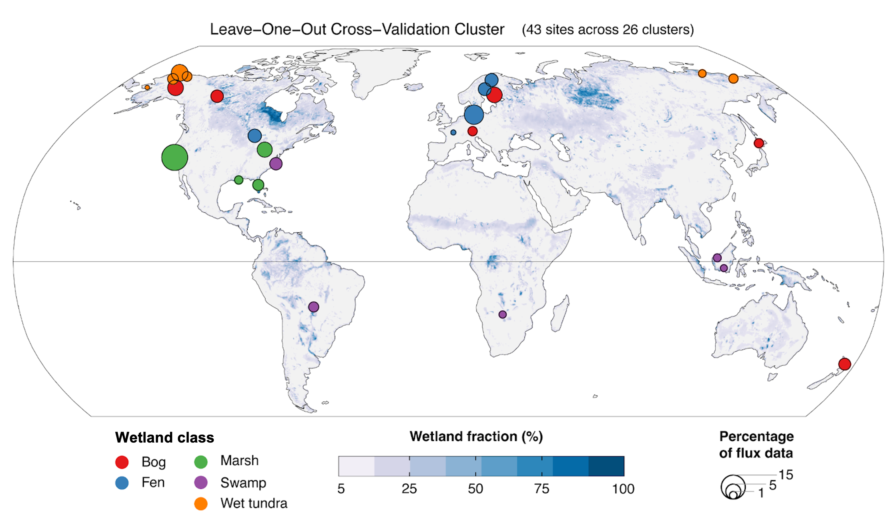
Global Wetland Methane Emissions derived from FLUXNET and the UpCH4 Model, 2001-2018
National Aeronautics and Space Administration —
This dataset provides monthly globally gridded freshwater wetland methane emissions from 2001-2018 in nmol CH4 m-2 s-1, g C-CH4 m-2 d-1, and TgCH4 grid cell-1... -
Federal
1996 Average Monthly Sea Surface Temperature for California
National Oceanic and Atmospheric Administration, Department of Commerce —
The NOAA/ NASA AVHRR Oceans Pathfinder sea surface temperature data are derived from the 5-channel Advanced Very High Resolution Radiometers (AVHRR) on board the NOAA... -
Federal
Wave Energy Prize - 1/20th Testing - SEWEC Attenuator
Department of Energy —
Data from the 1/20th scale testing data completed on the Wave Energy Prize for the SEWEC team, including the 1/20th scale test plan, raw test data, video, photos, and... -
Federal
2002 Average Monthly Sea Surface Temperature for California
National Oceanic and Atmospheric Administration, Department of Commerce —
The NOAA/ NASA AVHRR Oceans Pathfinder sea surface temperature data are derived from the 5-channel Advanced Very High Resolution Radiometers (AVHRR) on board the NOAA... -
Federal
LBA-ECO TG-02 Biogenic VOC Emissions from Brazilian Amazon Forest and Pasture Sites
National Aeronautics and Space Administration —
This data set reports concentrations of biogenic volatile organic compounds (BVOCs) collected from tethered balloon-sampling platforms above selected forest and... -
Federal
2000 Average Monthly Sea Surface Temperature for California
National Oceanic and Atmospheric Administration, Department of Commerce —
The NOAA/ NASA AVHRR Oceans Pathfinder sea surface temperature data are derived from the 5-channel Advanced Very High Resolution Radiometers (AVHRR) on board the NOAA... -
Federal
Data from: Eleven years of mountain weather, snow, soil moisture and stream flow data from the rain-snow transition zone - the Johnston Draw catchment, Reynolds Creek Experimental Watershed and Critical Zone Observatory, USA. v1.1
Department of Agriculture —
Detailed hydrometeorological data from the mountain rain-to-snow transition zone are present for water years 2004 through 2014. The Johnston Draw watershed (1.8 km2),... -
Federal
Granite Springs Valley, Nevada Play Fairway Analysis - Well data and Temperature Survey
Department of Energy —
This data is associated with the Nevada Play Fairway project and includes excel files containing raw 2-meter temperature data and corrections. GIS shapefiles and... -
Federal
2001 Average Monthly Sea Surface Temperature for California
National Oceanic and Atmospheric Administration, Department of Commerce —
The NOAA/ NASA AVHRR Oceans Pathfinder sea surface temperature data are derived from the 5-channel Advanced Very High Resolution Radiometers (AVHRR) on board the NOAA...

Official websites use .gov
A
.gov website belongs to an official government
organization in the United States.
Secure .gov websites use HTTPS
A
lock (
) or https:// means you’ve safely connected to
the .gov website. Share sensitive information only on official,
secure websites.