

72 datasets found for "◀카톡892jmsl상조내구제"
-
County
Allegheny County Property Assessments
Allegheny County / City of Pittsburgh / Western PA Regional Data Center —
Real Property parcel characteristics for Allegheny County, PA. Includes information pertaining to land, values, sales, abatements, and building characteristics (if... -
Federal
Time-Series Data on the Ocean and Great Lakes Economy for Counties, States, and the Nation between 2005 and 2019 (Sector Level)
National Oceanic and Atmospheric Administration, Department of Commerce —
Economics: National Ocean Watch (ENOW) contains annual time-series data for over 400 coastal counties, 30 coastal states, 8 regions, and the nation, derived from the... -
State
Mortality Following Hip Fracture Repair in California Hospitals
State of California —
This dataset contains risk-adjusted mortality rates, expected mortality rates, observed mortality rates, quality ratings, and the number of deaths and cases for hip... -
Federal
PEM West A Model Data
National Aeronautics and Space Administration —
PEM-West-A_Model_Data is the model data collected during the Pacific Exploratory Mission (PEM) West A suborbital campaign. Data collection for this product is... -
Federal
The Bushland, Texas Soybean Datasets
Department of Agriculture —
This parent dataset (collection of datasets) describes the general organization of data in the datasets for the 1995, 2003, 2004, 2010 and 2019 growing seasons... -
Federal
Digital Geologic-GIS Map of the Cave Creek School Quadrangle, Texas (NPS, GRD, GRI, LYJO, CCSC digital map) adapted from a Texas Bureau of Economic Geology, University of Texas at Austin Geologic Quadrangle Map by Barnes (1967)
Department of the Interior —
The Digital Geologic-GIS Map of the Cave Creek School Quadrangle, Texas is composed of GIS data layers and GIS tables, and is available in the following GRI-supported... -
Federal
Private School Locations 2019-20
Department of Education —
The National Center for Education Statistics’ (NCES) Education Demographic and Geographic Estimate (EDGE) program develops bi-annually updated point locations... -
Federal
Compiled Groundwater Chemistry Data and Identified Mineralogy for the Portland Basin CRBG Aquifer System as part of DDU Feasibility Study
Department of Energy —
Groundwater Chemistry data for the Portland Basin was compiled from published literature, as well as state and federal groundwater quality reports. Mineralogies were... -
Federal
Distributed Anomaly Detection using 1-class SVM for Vertically Partitioned Data
National Aeronautics and Space Administration —
There has been a tremendous increase in the volume of sensor data collected over the last decade for different monitoring tasks. For example, petabytes of earth... -
Federal
VIIRS/JPSS1 Gross Primary Productivity and Net Photosynthesis 8-Day L4 Global 500m SIN Grid V002
National Aeronautics and Space Administration —
The NOAA-20 Visible Infrared Imaging Radiometer Suite (VIIRS) Gross Primary Productivity (GPP) and Net Photosynthesis (PSN) (VJ117A2) Version 2 data product is a... -
Federal
BOREAS TF-04 SSA-YJP Tower Flux, Meteorological, and Canopy Condition Data, R1
National Aeronautics and Space Administration —
The BOREAS TF-04 team collected energy, carbon dioxide, and water vapor flux data at the BOREAS SSA-YJP site during the growing season of 1994. In addition,... -
Federal
OMPS-NPP L2 NM Formaldehyde (HCHO) Total Column swath orbital
National Aeronautics and Space Administration —
The OMPS-NPP L2 NM Formaldehyde (HCHO) Total Column swath orbital product provides formaldehyde measurements from the Ozone Mapping and Profiling Suite (OMPS) Nadir-... -
Federal
MODIS/Aqua Aerosol 5-Min L2 Swath 3km
National Aeronautics and Space Administration —
The new Collection 6.1 (C61) MODIS/Aqua Aerosol 5 Min L2 Swath 3km (MYD04_3K) product is an improved version based on algorithm changes in Dark Target (DT) Aerosol... -
Federal
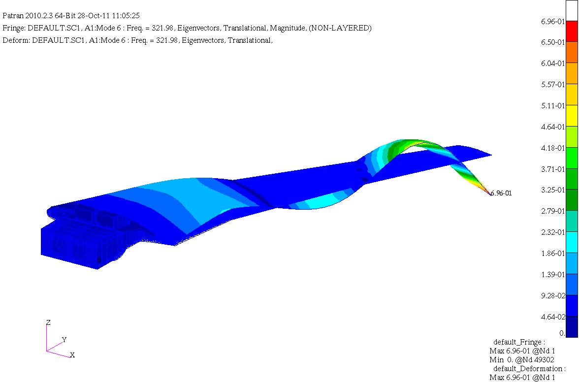
HIRENASD Comparisons of FEM modal frequencies and modeshapes
National Aeronautics and Space Administration —
Below are frequency comparisons of different models with experiment Note Modeshapes aren't very descriptive for higher modes. There is coupling between them so this... -
Federal
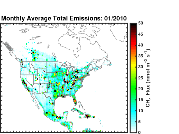
Methane (CH4) Flux for North America L4 Daily V1 (CMS_CH4_FLX_NAD) at GES DISC
National Aeronautics and Space Administration —
The CMS Methane (CH4) Flux for North America data set contains estimates of methane emission in North America based on an inversion of the GEOS-Chem chemical... -
Federal
Digital Geologic-GIS Map of Fredericksburg and Spotsylvania County Battlefields Memorial National Military Park and Vicinity, Virginia (NPS, GRD, GRI, FRSP, FRSP digital map) adapted from a U.S. Geological Survey Geologic Investigations Series Map by Mixon, Pavlides, Powars, Froelich, Weems, Schindler, Newell, Edwards and Ward (2000)
Department of the Interior —
The Digital Geologic-GIS Map of Fredericksburg and Spotsylvania County Battlefields Memorial National Military Park and Vicinity, Virginia is composed of GIS data... -
Federal
The Bushland, Texas Sunflower Datasets
Department of Agriculture —
This parent dataset (collection of datasets) describes the general organization of data in the datasets for the 2009 and 2011 growing seasons (year) when sunflower...
72 datasets found for "◀카톡892jmsl상조내구제"