
-
Federal
New York State Mesonet IMPACTS V1
National Aeronautics and Space Administration —
The New York State Mesonet IMPACTS dataset is a browse-only dataset and consists of temperature, wind, wind direction, mean sea level pressure, precipitation, and... -
Federal
Puerto Rico Radiosondes CPEX-AW V1
National Aeronautics and Space Administration —
The Puerto Rico Radiosondes CPEX-AW dataset consists of atmospheric pressure, atmospheric temperature, relative humidity, wind speed, and wind direction measurements.... -
Federal
PREFIRE Auxiliary Meteorology Data for PREFIRE Satellite 1 version R01
National Aeronautics and Space Administration —
Polar Radiant Energy in the Far InfraRed Experiment (PREFIRE) Auxiliary Meteorology Data for PREFIRE Satellite 1 (PREFIRE_SAT1_AUX-MET) contains GEOS-IT analyses and... -
Federal
BOREAS AFM-02 Wyoming King Air 1994 Aircraft Sounding Data
National Aeronautics and Space Administration —
The BOREAS AFM-02 team used the University of Wyoming King Air aircraft during IFCs 1, 2, and 3 in 1994 to collected pass-by-pass fluxes (and many other statistics)... -
Federal
BOREAS/AES MARS-II 15-minute Surface Meteorological Data: 1994
National Aeronautics and Space Administration —
Canadian AES personnel collected several data sets related to surface and atmospheric meteorological conditions over the BOREAS region. This data set contains... -
Federal
BOREAS Follow-On HMet-03 Hourly Meteorological Data at Flux Towers, 1994-1996
National Aeronautics and Space Administration —
Point data developed from in situ observations at four flux tower sites were combined to produce continuous, above the canopy, meteorological forcing data sets. Data... -
Federal
BOREAS Follow-On HMet-02 Area and Regional Hourly Gridded Met. Data, 1994-1996
National Aeronautics and Space Administration —
Phase II and III gridded data sets have been generated by an objective analysis scheme using all of the surface meteorological station data over BOREAS region for... -
Federal
UNH TDP - Concurrent Measurements of Inflow, Power Performance, and Loads for a Grid-Synchronized Vertical Axis Cross-Flow Turbine Operating in a Tidal Estuary
Department of Energy —
This data was collected between October 12 and December 15 of 2021 at the University of New Hampshire (UNH) and Atlantic Marine Energy Center (AMEC) turbine... -
Federal
LBA-ECO LC-02 Daily Meteorological Data, Rio Branco, Acre, Brazil: 1970-2001
National Aeronautics and Space Administration —
This data set provides meteorological measurements collected from 3 different meteorological stations within a radius of 8 km in Rio Branco, Acre Brazil, for the... -
Federal
SAFARI 2000 Upper Air Meteorological Profiles, South Africa, Dry Season 2000
National Aeronautics and Space Administration —
The University of Wyoming has a series of balloonborne radiosonde measurements from all around the world, from the surface to 30 km. This data set contains upper air... -
Federal
SAFARI 2000 Meteorological Tower Measurements, Kruger National Park, 2000-2002
National Aeronautics and Space Administration —
An eddy covariance system mounted on a tower near the Skukuza Camp in Kruger National Park, South Africa, has been operating continuously since early 2000.... -
Federal
Wind Profile Data: Radiosonde (FIFE)
National Aeronautics and Space Administration —
The wind profile data described in this document were derived from the raw radiosonde data collected during FIFE by Dr. Wilfred H. Brutsaert during the summer and... -
Federal
BOREAS AFM-01 NOAA/ATDD Long-EZ Aircraft Flux Data over the SSA
National Aeronautics and Space Administration —
This data set contains measurements from the NOAA/ATDD Long-EZ Aircraft collected during the 1994 IFCs at the SSA. These measurements were made from various... -
Federal
PREFIRE Auxiliary Meteorology Data for PREFIRE Satellite 2 R01
National Aeronautics and Space Administration —
Polar Radiant Energy in the Far InfraRed Experiment (PREFIRE) Auxiliary Meteorology Data for PREFIRE Satellite 2 (PREFIRE_SAT2_AUX-MET) contains GEOS-IT analyses and... -
Federal
CAMEX-3 ER-2 NAVIGATION V1
National Aeronautics and Space Administration —
The CAMEX-3 ER-2 Navigation data files contain information recorded by on board navigation and data collection systems. In addition to typical navigation data (e.g.... -
Federal
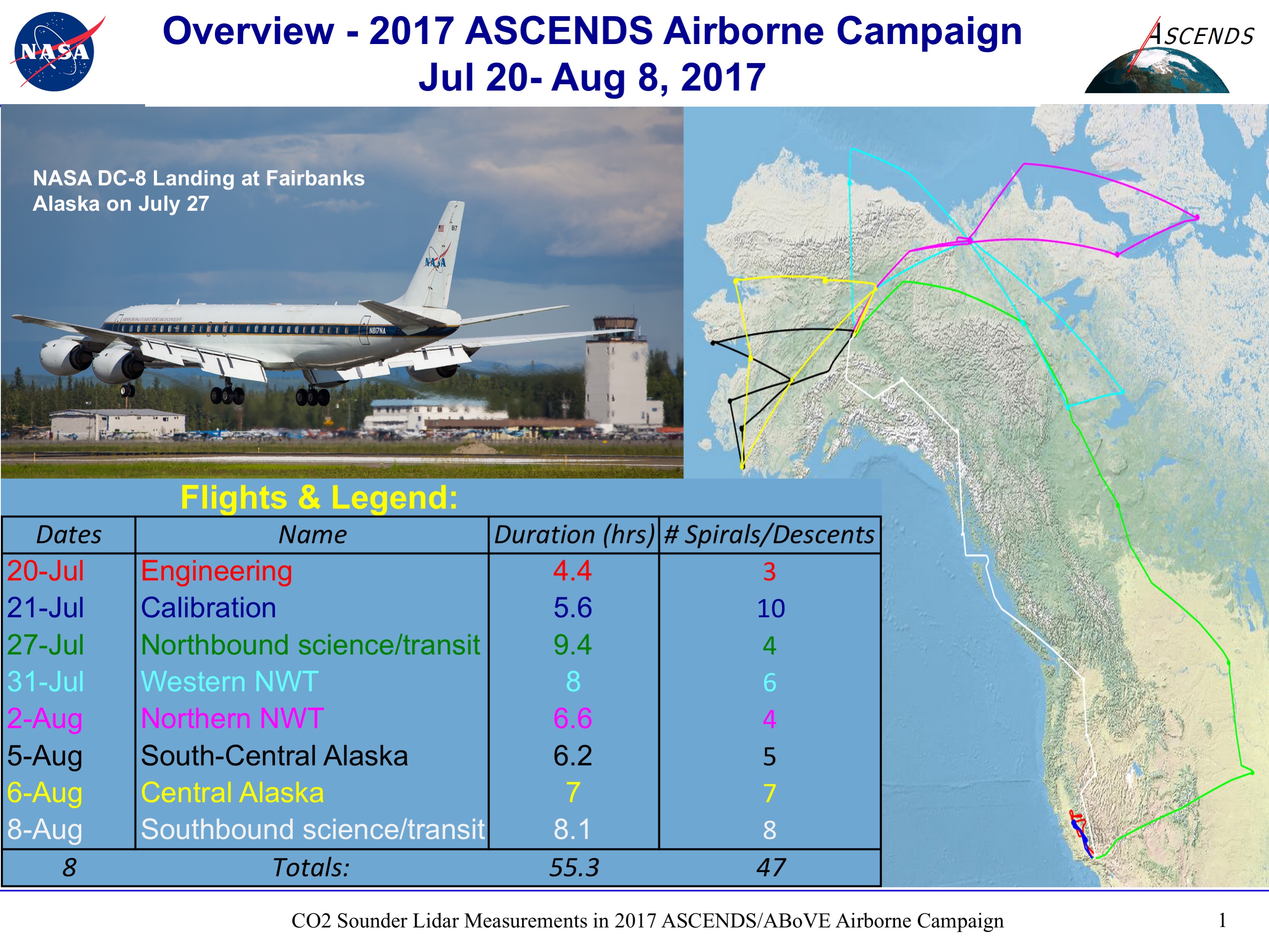
ABoVE/ASCENDS: Merged Atmospheric CO2, CH4, and Meteorological Data, 2017
National Aeronautics and Space Administration —
This dataset provides in situ airborne measurements of atmospheric carbon dioxide (CO2), methane (CH4), water vapor concentrations, air temperature, pressure, and... -
Federal
CALIPSO Lidar Level 2 Blowing Snow - Greenland, V1-00
National Aeronautics and Space Administration —
CAL_LID_L2_BlowingSnow_Greenland-Standard-V1-00 is the Cloud-Aerosol Lidar and Infrared Pathfinder Satellite Observations (CALIPSO) Lidar Level 2 Blowing Snow -... -
Federal
CALIPSO Lidar Level 2 Blowing Snow - Antarctica, V1-00
National Aeronautics and Space Administration —
CAL_LID_L2_BlowingSnow_Antarctica-Standard-V1-00 is the Cloud-Aerosol Lidar and Infrared Pathfinder Satellite Observations (CALIPSO) Lidar Level 2 Blowing Snow -... -
Federal
BOREAS Saskatchewan Forest Fire Control Centre Surface Meteorological Data
National Aeronautics and Space Administration —
The Saskatchewan Forest Fire Control Centre (SFFCC) provided surface meteorological data to BOREAS from their archive. This data set contains hourly surface... -
Federal
Daily SnowModel Outputs Covering the ABoVE Core Domain, 3-km Resolution, 1980-2020
National Aeronautics and Space Administration —
This dataset provides daily SnowModel simulation outputs on a 3-km grid for the period 1 September 1980 through 31 August 2020, covering the Core ABoVE Domain. The...

Official websites use .gov
A
.gov website belongs to an official government
organization in the United States.
Secure .gov websites use HTTPS
A
lock (
) or https:// means you’ve safely connected to
the .gov website. Share sensitive information only on official,
secure websites.