

25 datasets found for ""Fish and wildlife service""
-
Federal
Series of aerial images over Monte Vista National Wildlife Refuge, acquired September 8, 1985
Department of the Interior —
This data set includes two georeferenced versions of color aerial photographs from September 8, 1985, taken over Monte Vista National Wildlife Refuge. A georeferenced... -
Federal
Series of aerial images over Alamosa National Wildlife Refuge, acquired November 1941
Department of the Interior —
This data set includes 20 georeferenced versions of original black and white aerial photographs acquired in digital form from the National Archives and Records... -
Federal
Western bumble bee predicted occupancy and detection probability rasters for the western continental United States from 1998 to 2018
Department of the Interior —
These data represent occupancy estimates for western bumble bee across the western continental United States and the spatial variation in detection probabilities that... -
Federal
Chesapeake Bay and the Outer Coasts of Maryland and Virginia 2016 ESI BENTHIC Polygons
National Oceanic and Atmospheric Administration, Department of Commerce —
This data set contains sensitive biological resource data for submerged aquatic vegetation (SAV) in Chesapeake Bay and the Outer Coasts of Maryland and Virginia.... -
Federal
Aerial image taken over Monte Vista National Wildlife Refuge, acquired June 27, 1975
Department of the Interior —
Georeferenced aerial image from June 27th, 1975, taken over Monte Vista National Wildlife Refuge. Like other historic photos, this image allows for interpretation of... -
Federal
Series of aerial images over Monte Vista National Wildlife Refuge, acquired July 13th, 1965
Department of the Interior —
This data set includes 31 georeferenced versions of black and white aerial photographs from July 13th, 1965, taken over Monte Vista National Wildlife Refuge. A... -
Federal
Series of aerial images over Baca National Wildlife Refuge, acquired November, 1941
Department of the Interior —
This data set includes 59 georeferenced versions of original black and white aerial photographs from November 1941, acquired in digital form from the National... -
Federal
Series of aerial images over Monte Vista National Wildlife Refuge, acquired August 10, 1988
Department of the Interior —
This data set includes two georeferenced versions of color aerial photographs from August 10, 1988, taken over Monte Vista National Wildlife Refuge. Like other... -
Federal
Series of aerial images over Baca National Wildlife Refuge, acquired in 1953
Department of the Interior —
This data set includes 23 georeferenced and clipped versions of aerial photographs acquired September 29th and October 1st, 1953, over Baca National Wildlife Refuge.... -
Federal
Hydrologic and Landscape Database for the Clarks River National Wildlife Refuge and Contributing Watersheds, Kentucky, Tennessee, and Mississippi
Department of the Interior —
This hydrologic and landscape database was developed by the U.S. Geological Survey, in cooperation with the U.S. Fish and Wildlife Service for the Clarks River... -
Federal
Series of aerial images over Alamosa National Wildlife Refuge, acquired July, 1988
Department of the Interior —
This data set includes seven georeferenced and clipped versions of aerial photographs from July 22nd, 1988, taken over Alamosa National Wildlife Refuge. A... -
Federal
Hydrologic and Landscape Database for the Lower Suwannee River National Wildlife Refuge and Contributing Watersheds, Florida and Georgia
Department of the Interior —
This hydrologic and landscape database was developed by the U.S. Geological Survey, in cooperation with the U.S. Fish and Wildlife Service for the Lower Suwannee... -
Federal
Hydrologic and Landscape Database for the Okefenokee National Wildlife Refuge and Contributing Watersheds, Florida and Georgia
Department of the Interior —
This hydrologic and landscape database was developed by the U.S. Geological Survey, in cooperation with the U.S. Fish and Wildlife Service for the Okefenokee National... -
Federal
Series of aerial images over Baca National Wildlife Refuge, acquired July, 1988
Department of the Interior —
This data set includes 21 georeferenced and clipped versions of aerial photographs from July 22nd, 1988, taken over Baca National Wildlife Refuge. A georeferenced... -
Federal
Five Hydrologic and Landscape Databases for Select National Wildlife Refuges in Southeastern United States
Department of the Interior —
Five hydrologic and landscape databases were developed by the U.S. Geological Survey, in cooperation with the U.S. Fish and Wildlife Service, for select National... -
Federal
Hydrologic and Landscape Database for the Cahaba River National Wildlife Refuge and Contributing Watersheds, Alabama
Department of the Interior —
This hydrologic and landscape database was developed by the U.S. Geological Survey, in cooperation with the U.S. Fish and Wildlife Service for the Cahaba River... -
Federal
Hydrologic and Landscape Database for the Caloosahatchee and "Ding" Darling National Wildlife Refuges and Contributing Watersheds, Florida
Department of the Interior —
This hydrologic and landscape database was developed by the U.S. Geological Survey, in cooperation with the U.S. Fish and Wildlife Service for the Caloosahatchee and... -
Federal
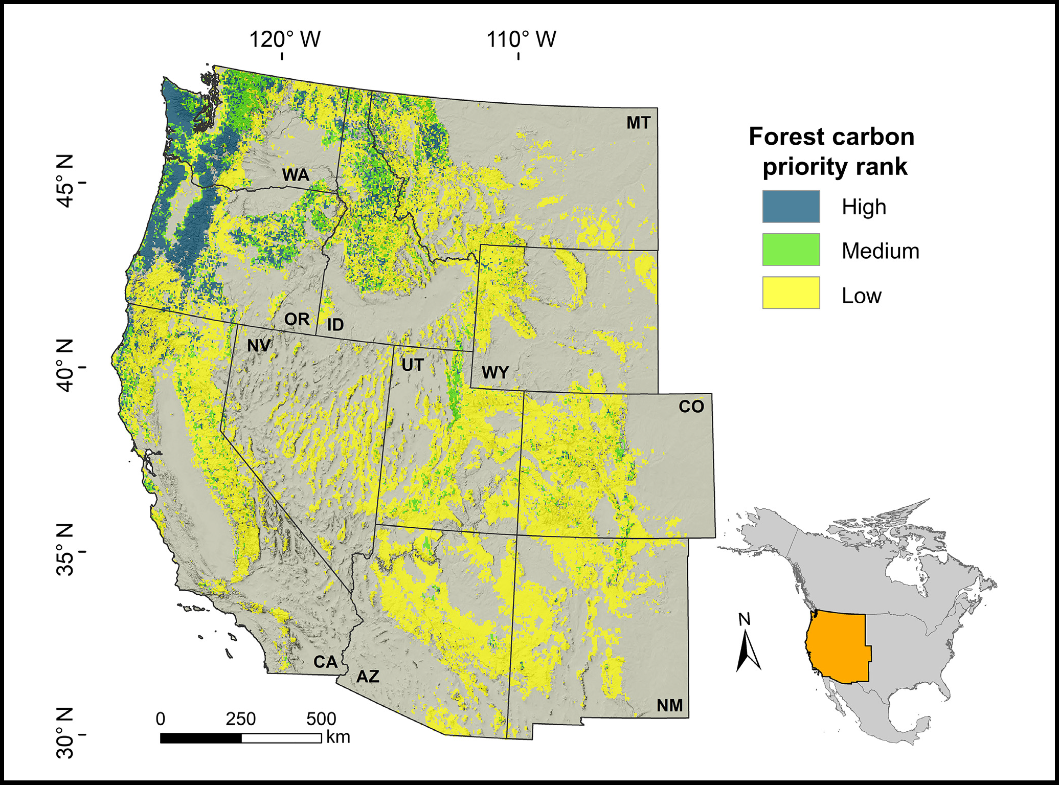
Forest Preservation Ranking and Vertebrate Species Richness, Western USA, 2020-2099
National Aeronautics and Space Administration —
This dataset provides related gridded outputs of future modeled forest carbon sequestration priority and related species richness and habitat suitability for the... -
Federal
Series of aerial images over Monte Vista National Wildlife Refuge, acquired August 26th, 1989
Department of the Interior —
This data set includes five georeferenced versions of color aerial photographs from August 26th, 1989, taken over Monte Vista National Wildlife Refuge. Like other... -
Federal
Species occurrence data from the Range-Wide Bull Trout eDNA Project
Department of Agriculture —
These data include 2015 - 2018 eDNA field sample points indicating lab results for presence or absence of bull trout. Sample sites are spaced at a 1 kilometer...
25 datasets found for ""Fish and wildlife service""