
-
Federal
Daily and Annual PM2.5, O3, and NO2 Concentrations at ZIP Codes for the Contiguous U.S., 2000-2016, v1.0
National Aeronautics and Space Administration —
The Daily and Annual PM2.5, O3, and NO2 Concentrations at ZIP Codes for the Contiguous U.S., 2000-2016, v1.0 data set contains daily and annual concentration... -
Federal
Global Man-made Impervious Surface (GMIS) Dataset From Landsat
National Aeronautics and Space Administration —
The Global Man-made Impervious Surface (GMIS) Dataset From Landsat consists of global estimates of fractional impervious cover derived from the Global Land Survey... -
Federal
Global Human Built-up And Settlement Extent (HBASE) Dataset From Landsat
National Aeronautics and Space Administration —
The Global Human Built-up And Settlement Extent (HBASE) Dataset from Landsat is a global map of HBASE derived from the Global Land Survey (GLS) Landsat dataset for... -
Federal
Last of the Wild Project, Version 2, 2005 (LWP-2): Global Human Footprint Dataset (Geographic)
National Aeronautics and Space Administration —
The Global Human Footprint Dataset of the Last of the Wild Project, Version 2, 2005 (LWP-2) is the Human Influence Index (HII) normalized by biome and realm. The HII... -
Federal
Last of the Wild Project, Version 2, 2005 (LWP-2): Global Human Influence Index (HII) Dataset (Geographic)
National Aeronautics and Space Administration —
The Global Human Influence Index Dataset of the Last of the Wild Project, Version 2, 2005 (LWP-2) is a global dataset of 1-kilometer grid cells, created from nine... -
Federal
Global 3-Year Running Mean Ground-Level Nitrogen Dioxide (NO2) Grids from GOME, SCIAMACHY and GOME-2
National Aeronautics and Space Administration —
The Global 3-Year Running Mean Ground-Level Nitrogen Dioxide (NO2) Grids from GOME, SCIAMACHY and GOME-2 represent a series of three-year running mean grids... -
Federal
Daily and Annual NO2 Concentrations for the Contiguous United States, 1-km Grids, v1 (2000 - 2016)
National Aeronautics and Space Administration —
The Daily and Annual NO2 Concentrations for the Contiguous United States, 1-km Grids, v1 (2000-2016) data set contains daily predictions of Nitrogen Dioxide (NO2)... -
Federal
Last of the Wild Project, Version 1, 2002 (LWP-1): Last of the Wild Dataset (Geographic)
National Aeronautics and Space Administration —
The Last of the Wild Dataset of the Last of the Wild Project, Version 1, 2002 (LWP-1) is derived from the LWP-1 Human Footprint Dataset. The gridded data are... -
Federal
Altimeter Corrected Elevations, Version 2 (ACE2)
National Aeronautics and Space Administration —
The Altimeter Corrected Elevations, Version 2 (ACE2) data set, is the Global Digital Elevation Model (GDEM) created by using multi-mission Satellite Radar Altimetry... -
Federal
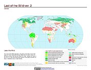
Last of the Wild Project, Version 2, 2005 (LWP-2): Last of the Wild Dataset (Geographic)
National Aeronautics and Space Administration —
The Last of the Wild Dataset of the Last of the Wild Project, Version 2, 2005 (LWP-2) is derived from the LWP-2 Human Footprint Dataset. The gridded data are... -
Federal
Water Security Indicator Model - Global Land Data Assimilation System (WSIM-GLDAS) Monthly Grids, Version 1
National Aeronautics and Space Administration —
The Water Security Indicator Model - Global Land Data Assimilation System (WSIM-GLDAS) Monthly Grids, Version 1 data set identifies and characterizes surpluses and... -
Federal
Global Mangrove Forests Distribution, 2000
National Aeronautics and Space Administration —
The Global Mangrove Forests Distribution, 2000 data set is a compilation of the extent of mangroves forests from the Global Land Survey and the Landsat archive with... -
Federal
Daily 8-Hour Maximum and Annual O3 Concentrations for the Contiguous United States, 1-km Grids, Version 1.10 (2000-2016)
National Aeronautics and Space Administration —
The Daily 8-Hour Maximum and Annual O3 Concentrations for the Contiguous United States, 1-km Grids, Version 1.10 (2000-2016) data set contains estimates of ozone... -
Federal
IPCC Fourth Assessment Report (AR4) Observed Climate Change Impacts Database
National Aeronautics and Space Administration —
The Intergovernmental Panel on Climate Change (IPCC) Fourth Assessment Report (AR4) Observed Climate Change Impacts Database contains observed responses to climate... -
Federal
Global Database of Light-based Geospatial Income Inequality (LGII) Measures, Version 1
National Aeronautics and Space Administration —
The Global Database of Light-based Geospatial Income Inequality (LGII) Measures, Version 1 data set contains Gini-coefficients of inequality for 234 countries and... -
Federal
Daily 8-Hour Maximum and Annual O3 Concentrations for the Contiguous United States, 1-km Grids, v1 (2000 - 2016)
National Aeronautics and Space Administration —
The Daily 8-Hour Maximum and Annual O3 Concentrations for the Contiguous United States, 1-km Grids, v1 (2000 - 2016) data set contains estimates of ozone... -
Federal
Last of the Wild Project, Version 1, 2002 (LWP-1): Global Human Footprint Dataset (Geographic)
National Aeronautics and Space Administration —
The Global Human Footprint Dataset of the Last of the Wild Project, Version 1, 2002 (LWP-1) is the Human Influence Index (HII) normalized by biome and realm. The HII... -
Federal
Central American Vegetation/Land Cover Classification and Conservation Status
National Aeronautics and Space Administration —
The Central American Vegetation/Land Cover Classification and Conservation Status consists of GIS coverages of vegetation classes (forests, woodlands, savannas,...

Official websites use .gov
A
.gov website belongs to an official government
organization in the United States.
Secure .gov websites use HTTPS
A
lock (
) or https:// means you’ve safely connected to
the .gov website. Share sensitive information only on official,
secure websites.