
-
Federal
NACP North American Forest Dynamics Project: Forest Disturbance and Regrowth Data
National Aeronautics and Space Administration —
This data set provides the results of time-series analyses of Landsat imagery for 55 selected forested sites across the conterminous U.S.A. The output is a pair of... -
Federal
MASTER: Airborne Science, Nevada, May 2006
National Aeronautics and Space Administration —
This dataset includes Level 1B (L1B) data products from the MODIS/ASTER Airborne Simulator (MASTER) instrument. The spectral data were collected during five flights... -
Federal
Soil Moisture Profiles and Temperature Data from SoilSCAPE Sites, USA
National Aeronautics and Space Administration —
This data set contains in-situ soil moisture profile and soil temperature data collected at 20-minute intervals at SoilSCAPE (Soil moisture Sensing Controller and... -
Federal
Daily Rainfall Data (FIFE)
National Aeronautics and Space Administration —
The FIFE Daily Rainfall Data Set contains daily precipitation values for 42 rain gauge stations within the Konza LTER portion of the FIFE site (i.e., Northwest... -
Federal
LBA Regional Mean Climatology, 0.5-Deg, 1930-1960, V. 2.1 (Cramer and Leemans)
National Aeronautics and Space Administration —
This data set is a subset of Cramer and Leemans' (2001) global database of mean monthly climatology, which contains monthly averages of mean temperature, temperature... -
Federal
Arctic Vegetation Plots for IBP Tundra Biome, Barrow, Alaska, 1972-2010
National Aeronautics and Space Administration —
This data set provides vegetation cover and environmental plot data collected as part of the International Biological Program (IBP), U. S. Tundra Biome Program, in... -
Federal
Global Forest Ecosystem Structure and Function Data For Carbon Balance Research
National Aeronautics and Space Administration —
A comprehensive global database has been assembled to quantify CO2 fluxes and pathways across different levels of integration (from photosynthesis up to net ecosystem... -
Federal
L2 Daily Solar-Induced Fluorescence (SIF) from ERS-2 GOME, 1995-2003
National Aeronautics and Space Administration —
This dataset provides Level 2 Solar-Induced Fluorescence (SIF) of Chlorophyll estimates derived from the Global Ozone Monitoring Experiment (GOME) instrument on the... -
Federal
Global Distribution of Plant-Extractable Water Capacity of Soil (Dunne)
National Aeronautics and Space Administration —
Plant-extractable water capacity of soil is the amount of water that can be extracted from the soil to fulfill evapotranspiration demands. It is often assumed to be... -
Federal
LiDAR Derived Biomass, Canopy Height, and Cover for New England Region, USA, 2015
National Aeronautics and Space Administration —
This dataset provides 30 m gridded estimates of aboveground biomass density (AGBD), forest canopy height, and tree canopy coverage for the New England Region of the... -
Federal
ABoVE: Light-Curve Modelling of Gridded GPP Using MODIS MAIAC and Flux Tower Data
National Aeronautics and Space Administration —
This dataset contains gridded estimations of daily ecosystem Gross Primary Production (GPP) in grams of carbon per day at a 1 km2 spatial resolution over Alaska and... -
Federal
GEDI L4C Footprint Level Waveform Structural Complexity Index, Version 2
National Aeronautics and Space Administration —
This dataset contains Global Ecosystem Dynamics Investigation (GEDI) Level 4C (L4C) Version 2 predictions of the Waveform Structural Complexity Index (WSCI) and... -
Federal
BOREAS TGB-09 Above-canopy NMHC at SSA-OBS, SSA-OJP and SSA-OA Sites
National Aeronautics and Space Administration —
THE BOREAS TGB-09 team collected data in order to inventory and quantify the anthropogenic and biogenic NMHC's over the BOREAS study areas. This data set contains... -
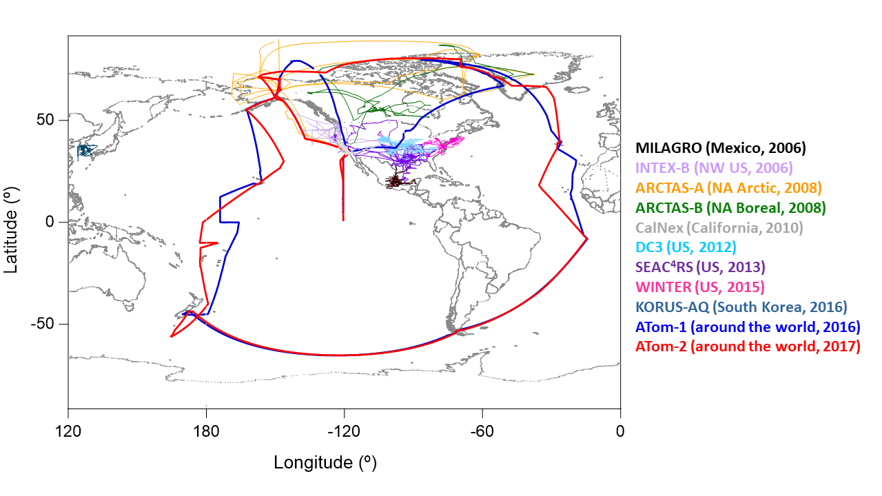
Federal
Airborne Observations and Modeling Comparison of Global Inorganic Aerosol Acidity
National Aeronautics and Space Administration —
This dataset provides observations collected during eleven airborne campaigns from 2006–2017 and associated input and output from nine widely used chemical transport... -
Federal
Global Vegetation Types, 1971-1982 (Matthews)
National Aeronautics and Space Administration —
The global vegetation type data of 1 x 1 degree latitude and longitude resolution were designed for use in studies of climate and climate change. Vegetation data were... -
Federal
MASTER: California Fires, California, November 2007
National Aeronautics and Space Administration —
This dataset includes Level 1B (L1B) data products from the MODIS/ASTER Airborne Simulator (MASTER) instrument. The spectral data were collected during six flights... -
Federal
SAFARI 2000 Stem and Canopy Characterization, Kalahari Transect, 1995-2000
National Aeronautics and Space Administration —
This data set provides species distribution, basal area, height, and crown cover of woody stems at 10 sites along the Kalahari Transect where a large gradient in both...

Official websites use .gov
A
.gov website belongs to an official government
organization in the United States.
Secure .gov websites use HTTPS
A
lock (
) or https:// means you’ve safely connected to
the .gov website. Share sensitive information only on official,
secure websites.