
-
Federal
NACP North American Forest Dynamics Project: Forest Disturbance and Regrowth Data
National Aeronautics and Space Administration —
This data set provides the results of time-series analyses of Landsat imagery for 55 selected forested sites across the conterminous U.S.A. The output is a pair of... -
Federal
Global Data Set of Derived Soil Properties, 0.5-Degree Grid (ISRIC-WISE)
National Aeronautics and Space Administration —
The World Inventory of Soil Emission Potentials (WISE) database currently contains data for over 4300 soil profiles collected mostly between 1950 and 1995. This... -
Federal
NACP Aboveground Biomass and Carbon Baseline Data, V.2 (NBCD 2000), U.S.A., 2000
National Aeronautics and Space Administration —
The NBCD 2000 (National Biomass and Carbon Dataset for the Year 2000) data set provides a high-resolution (30 m) map of year-2000 baseline estimates of basal area-... -
Federal
Global Historical Climatology Network, 1753-1990
National Aeronautics and Space Administration —
This data set contains monthly temperature, precipitation, sea-level pressure, and station-pressure data for thousands of meteorological stations worldwide. The... -
Federal
NACP Integrated Wildland and Cropland 30-m Fuel Characteristics Map, U.S.A., 2010
National Aeronautics and Space Administration —
The data set provides a 30-m comprehensive fuelbed characteristics map for both the wildland and cropland areas of the conterminous United States (CONUS) for 2010.... -
Federal
Vulcan: High-Resolution Hourly Fossil Fuel CO2 Emissions in USA, 2010-2015, Version 3
National Aeronautics and Space Administration —
The Vulcan version 3.0 hourly dataset quantifies hourly emissions at a 1-km resolution for the 2010-2015 time period. Estimates are provided of hourly carbon dioxide... -
Federal
Eddy Corr. Surface Flux: USGS (FIFE)
National Aeronautics and Space Administration —
Surface flux measurements were made at selected sites within the FIFE area. Each surface flux station was capable of measuring the fluxes of net radiation, sensible... -
Federal
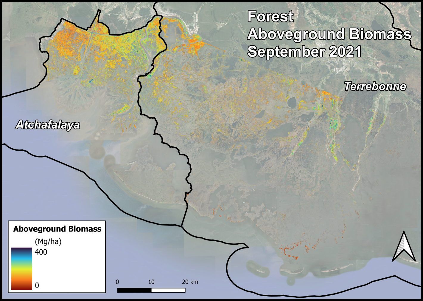
Delta-X AVIRIS-NG and UAVSAR L3 Derived Forest Aboveground Biomass, MRD, LA
National Aeronautics and Space Administration —
This dataset contains estimates of forest aboveground biomass (AGB) across the Atchafalaya and Terrebonne Basins, Louisiana, US. AGB was derived from AVIRIS-NG... -
Federal
VEMAP 2: U.S. Annual Climate Change Scenarios
National Aeronautics and Space Administration —
The Vegetation/Ecosystem Modeling and Analysis Project (VEMAP) Phase 2 has developed a number of transient climate change scenarios based on coupled atmosphere-ocean... -
Federal
Delta-X: Bed and Suspended Sediment Grain Size, MRD, LA, USA, 2019-2021, V3
National Aeronautics and Space Administration —
This dataset includes sediment concentration and grain size distribution measurements from suspended and bed sediment samples collected in the Atchafalaya River and... -
Federal
MASTER: FireSense, California and Southern US, Spring 2025
National Aeronautics and Space Administration —
This dataset includes Level 1B (L1B) and Level 2 (L2) data products from the MODIS/ASTER Airborne Simulator (MASTER) instrument. The spectral data were collected as... -
Federal
Gridded GEDI Vegetation Structure Metrics and Biomass Density at Multiple Resolutions
National Aeronautics and Space Administration —
This dataset consists of near-global, analysis-ready, multi-resolution gridded vegetation structure metrics derived from NASA Global Ecosystem Dynamics Investigation... -
Federal
ABoVE: Permafrost Measurements and Distribution Across the Y-K Delta, Alaska, 2016
National Aeronautics and Space Administration —
This dataset provides field observations of thaw depth and dominant vegetation types, a LiDAR-derived elevation map, and permafrost distribution and probability maps... -
Federal
NACP MsTMIP: Global 0.5-degree Model Outputs in Standard Format, Version 2.0
National Aeronautics and Space Administration —
This dataset provides an updated version of global gridded estimates of carbon, energy, and hydrologic fluxes between the land and atmosphere from 17 Terrestrial... -
Federal
ATom: L2 In Situ Measurements from NOAA Nitrogen Oxides and Ozone (NOyO3) Instrument
National Aeronautics and Space Administration —
This dataset provides in situ concentrations of nitric oxide (NO), nitrogen dioxide (NO2), total reactive nitrogen oxides (NOy), and ozone (O3) measured by the NOAA... -
Federal
MASTER: Airborne Science, Nevada, May 2006
National Aeronautics and Space Administration —
This dataset includes Level 1B (L1B) data products from the MODIS/ASTER Airborne Simulator (MASTER) instrument. The spectral data were collected during five flights... -
Federal
NACP Peatland Landcover Type and Wildfire Burn Severity Maps, Alberta, Canada
National Aeronautics and Space Administration —
This data set provides landcover maps of (1) peatland type (bog, fen, marsh, swamp) with levels of biomass (open, forested) and (2) Burn Severity Index (BSI) (Dyrness... -
Federal
LUH1: Harmonized Global Land Use for Years 1500-2100, V1
National Aeronautics and Space Administration —
These data represent fractional land use and land cover patterns annually for the years 1500 - 2100 for the globe at 0.5-degree (~50-km) spatial resolution. Land use...

Official websites use .gov
A
.gov website belongs to an official government
organization in the United States.
Secure .gov websites use HTTPS
A
lock (
) or https:// means you’ve safely connected to
the .gov website. Share sensitive information only on official,
secure websites.