
-
Federal
Global Vegetation Greenness (NDVI) from AVHRR GIMMS-3G+, 1981-2022
National Aeronautics and Space Administration —
This dataset holds the Global Inventory Modeling and Mapping Studies-3rd Generation V1.2 (GIMMS-3G+) data for the Normalized Difference Vegetation Index (NDVI). NDVI... -
Federal
ABoVE: Thaw Depth at Selected Unburned and Burned Sites Across Alaska
National Aeronautics and Space Administration —
This dataset provides thaw depth measurements made at seven locations across Alaska, during August 2016, June and September 2017, and July-August 2018. Three of the... -
Federal
MASTER: Costa Rica Airborne Research and Technology Applications (CARTA), 2005
National Aeronautics and Space Administration —
This dataset includes Level 1B (L1B) data products from the MODIS/ASTER Airborne Simulator (MASTER) instrument. The spectral data were collected during 23 flights... -
Federal
Arctic Boreal Annual Burned Area, Circumpolar Boreal Forest and Tundra, V2, 2002-2022
National Aeronautics and Space Administration —
This dataset provides annual cumulative end-of-season burned area in circumpolar boreal forests and tundra for the years 2002-2022. The data were generated using the... -
Federal
MASTER: California Fires, California, November 2007
National Aeronautics and Space Administration —
This dataset includes Level 1B (L1B) data products from the MODIS/ASTER Airborne Simulator (MASTER) instrument. The spectral data were collected during six flights... -
Federal
COMEX: AVIRIS-Classic Facility Instrument Associated Flights and Information, 2014
National Aeronautics and Space Administration —
This dataset lists flight lines and provides data access links and contextual flight information for a subset of the AVIRIS-Classic Facility Instrument Collection... -
Federal
ABoVE: Passive Microwave-derived Annual Snowpack Main Melt Onset Date Maps, 1988-2018
National Aeronautics and Space Administration —
This dataset provides the annual date of snowpack seasonal beginning melt (i.e., main melt onset date, MMOD) across northwest Canada; Alaska, U.S.; and parts of far... -
Federal
Arctic Vegetation Plots at Atqasuk, Alaska, 1975, 2000, and 2010
National Aeronautics and Space Administration —
This data set provides vegetation species abundance data collected in 1975 from 60 sites on the Arctic Coastal Plain near Atqasuk, Alaska, as well as environmental... -
Federal
Global Maps of Atmospheric Nitrogen Deposition, 1860, 1993, and 2050
National Aeronautics and Space Administration —
This data set provides global gridded estimates of atmospheric deposition of total inorganic nitrogen (N), NHx (NH3 and NH4+), and NOy (all oxidized forms of nitrogen... -
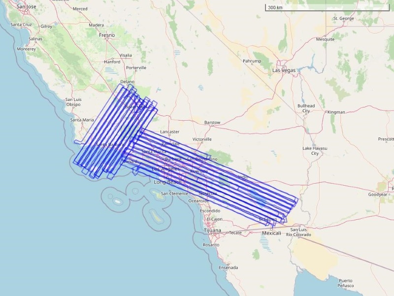
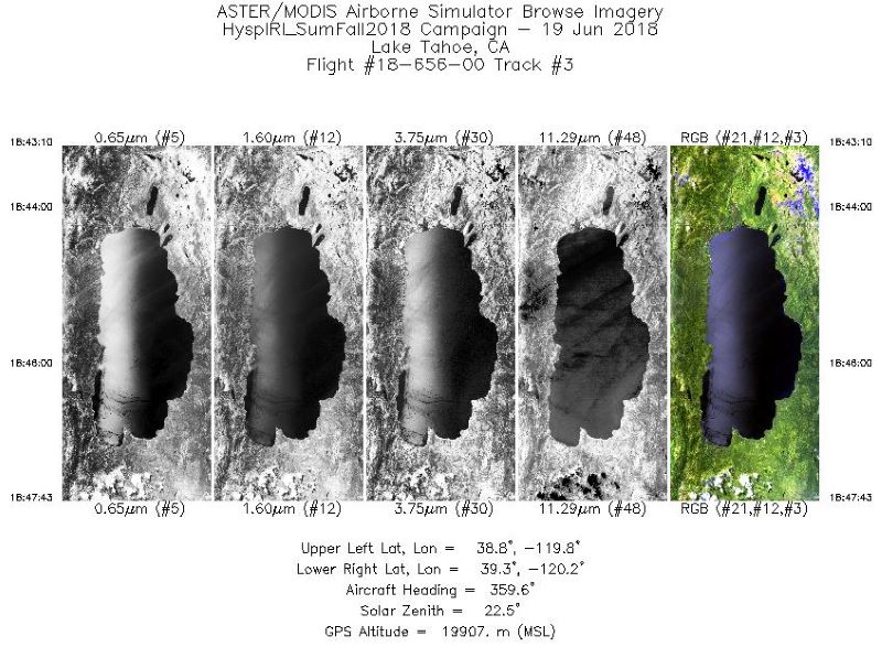
Federal
MASTER: HyspIRI Airborne Campaign, Western USA, Summer 2018
National Aeronautics and Space Administration —
This dataset includes Level 1B (L1B) and Level 2 (L2) data products from the MODIS/ASTER Airborne Simulator (MASTER) instrument. The spectral data were collected as... -
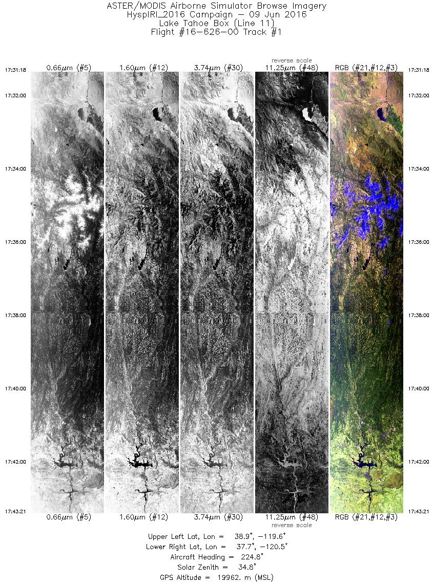
Federal
MASTER: HyspIRI Airborne Campaign, California and Nevada, Summer 2016
National Aeronautics and Space Administration —
This dataset includes Level 1B (L1B) and Level 2 (L2) data products from the MODIS/ASTER Airborne Simulator (MASTER) instrument. The data were collected as part of... -
Federal
PhenoCam Dataset v3.0: Vegetation Phenology from Digital Camera Imagery, 2000-2023
National Aeronautics and Space Administration —
This dataset provides vegetation phenological observations for 738 sites across diverse ecosystems of the world (mostly North America) from 2000 to 2023. The... -
Federal
Methane Emissions from Dairy Sources (Vista-CA), State of California, USA, 2019
National Aeronautics and Space Administration —
This dataset provides estimates of methane (CH4) emissions from dairies in California at a resolution of 0.1 degrees (~ 10 km x 10 km) for the year 2019. The mapped... -
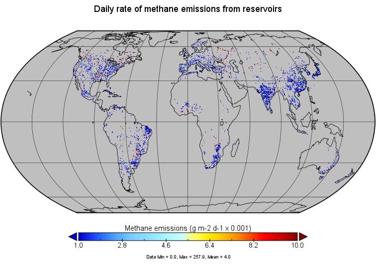
Federal
Global-Gridded Daily Methane Emissions from Inland Dam-Reservoir Systems
National Aeronautics and Space Administration —
This dataset includes global maps of methane (CH4) emissions from inland dam-reservoir systems at 0.25-degree spatial resolution. Daily emission rates (as grams of... -
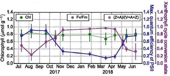
Federal
Conifer Needle Chlorophyll Fluorescence, Niwot Ridge, Colorado, USA, 2017-2018
National Aeronautics and Space Administration —
This dataset provides chlorophyll fluorescence measurements made on pine and spruce needle tissues at the Niwot Ridge AmeriFlux Core site (US-NR1) near Nederland,... -
Federal
Global Soil Types, 0.5-Degree Grid (Modified Zobler)
National Aeronautics and Space Administration —
A global data set of soil types is available at 0.5-degree latitude by 0.5-degree longitude resolution. There are 106 soil units, based on Zobler?s (1986) assessment... -
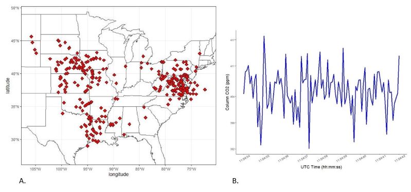
Federal
ACT-America: L2 Remotely Sensed Column-avg CO2 by Airborne Lidar, Lite, Eastern USA
National Aeronautics and Space Administration —
This dataset provides a direct subset (i.e., the Lite version) of the Level 2 (L2) remotely sensed column-average carbon dioxide (CO2) concentrations measured during... -
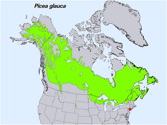
Federal
Spruce Leaf, Tree Traits, and Respiration at Range Extremes, AK and NY, USA, 2018
National Aeronautics and Space Administration —
This dataset provides in situ measurements of needle-level gas-exchange and leaf traits from Picea glauca (white spruce) from a field site located in the northern... -
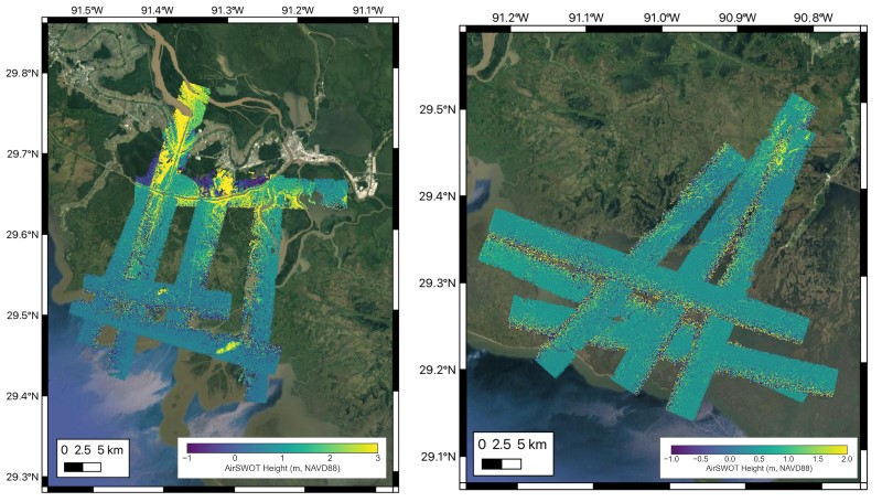
Federal
Delta-X: AirSWOT L2 Geocoded Water Surface Elevation, MRD, LA, 2021, V3
National Aeronautics and Space Administration —
This dataset contains Level 2 (L2) AirSWOT geocoded products, including estimated water surface elevation. The AirSWOT instrument is a Ka-band interferometer and for... -
Federal
ABoVE: Modeled Top Cover by Plant Functional Type over Alaska and Yukon, 1985-2020
National Aeronautics and Space Administration —
This dataset contains data files of modeled top cover estimates by plant functional type (PFT) for the Arctic and Boreal Alaska and Yukon regions. Estimates are...

Official websites use .gov
A
.gov website belongs to an official government
organization in the United States.
Secure .gov websites use HTTPS
A
lock (
) or https:// means you’ve safely connected to
the .gov website. Share sensitive information only on official,
secure websites.