
-
Federal
LBA-ECO CD-04 Soil Respiration, km 83 Tower Site, Tapajos National Forest, Brazil
National Aeronautics and Space Administration —
This data set reports on the flux of carbon dioxide from logged forest soils near the eddy flux tower at the km 83 site, Para, Brazil. The automated soil respiration... -
Federal
NACP Aboveground Biomass and Carbon Baseline Data, V.2 (NBCD 2000), U.S.A., 2000
National Aeronautics and Space Administration —
The NBCD 2000 (National Biomass and Carbon Dataset for the Year 2000) data set provides a high-resolution (30 m) map of year-2000 baseline estimates of basal area-... -
Federal
Aboveground Biomass, Landcover, and Degradation, Kalimantan Forests, Indonesia, 2014
National Aeronautics and Space Administration —
This dataset provides estimates of aboveground biomass, percent canopy cover, mean canopy height, landcover, and forest degradation index products for forests in... -
Federal
CMS: Forest Carbon Stocks, Emissions, and Net Flux for the Conterminous US: 2005-2010
National Aeronautics and Space Administration —
This data set provides maps of estimated carbon in forests of the 48 continental states of the US for the years 2005-2010. Carbon (termed committed carbon) stocks... -
Federal
GEDI L4A Footprint Level Aboveground Biomass Density, Version 1
National Aeronautics and Space Administration —
This dataset contains Global Ecosystem Dynamics Investigation (GEDI) Level 4A (L4A) predictions of the aboveground biomass density (AGBD; in Mg/ha) and estimates of... -
Federal
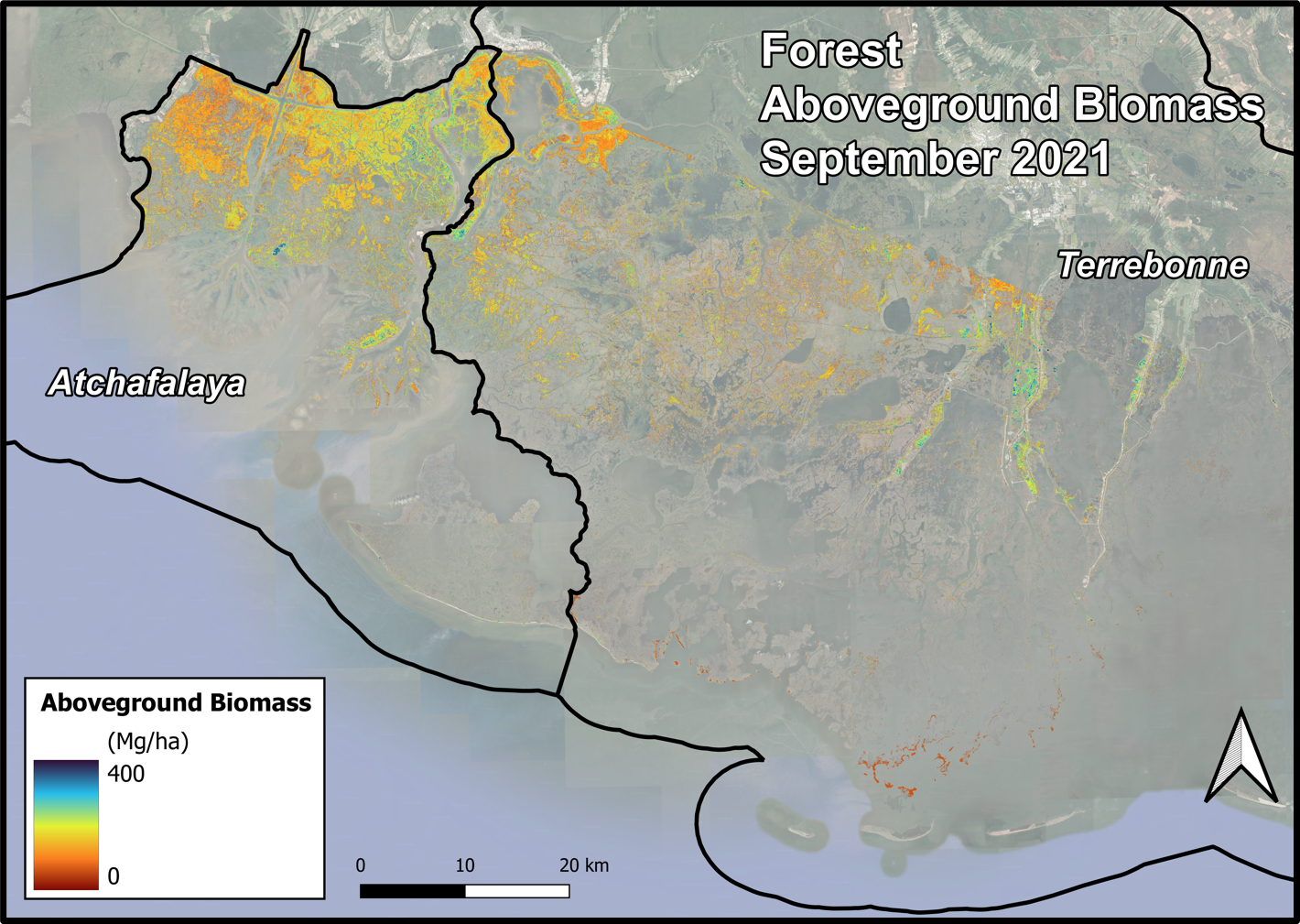
Delta-X AVIRIS-NG and UAVSAR L3 Derived Forest Aboveground Biomass, MRD, LA
National Aeronautics and Space Administration —
This dataset contains estimates of forest aboveground biomass (AGB) across the Atchafalaya and Terrebonne Basins, Louisiana, US. AGB was derived from AVIRIS-NG... -
Federal
ISLSCP II GlobalView: Atmospheric Methane Concentrations
National Aeronautics and Space Administration —
The GlobalView Methane (CH4) data product contains synchronized and smoothed time series of atmospheric CH4 concentrations at selected sites that were created using... -
Federal
LBA-ECO ND-30 Nutrient Analysis and Gas Fluxes, Forest Chronosequences, Para, Brazil
National Aeronautics and Space Administration —
This data set provides fine litterfall mass and nutrient concentrations from samples collected at chronosequences established at Sao Francisco do Para and Capitao... -
Federal
SAFARI 2000 Leaf-Level VOC Emissions, Maun, Botswana, Wet Season 2001
National Aeronautics and Space Administration —
Biogenic volatile organic compounds (VOCs) comprise a significant proportion of trace gases in the atmospheric environment and play an important role in the formation... -
Federal
BioSCape Vegetation Surveys Berg and Eerste River Catchments, South Africa, 2022-2023
National Aeronautics and Space Administration —
This dataset contains vegetation plot survey data collected at 36 sites across the Berg and Eerste River catchments in the Western Cape, South Africa collected during... -
Federal
Soil Thermal Conductivity Data (FIFE)
National Aeronautics and Space Administration —
The purpose of the 1989 FIFE soil properties investigation was to obtain a description of the thermal properties of the soils within the FIFE study area. Soil thermal... -
Federal
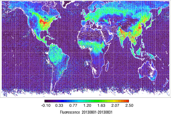
L2 Daily Solar-Induced Fluorescence (SIF) from MetOp-B GOME-2, 2013-2021
National Aeronautics and Space Administration —
This dataset provides Level 2 (L2) Solar-Induced Fluorescence (SIF) of chlorophyll estimates derived from the Global Ozone Monitoring Experiment 2 (GOME-2) instrument... -
Federal
ABoVE: Riverbank Erosion and Vegetation Changes, Yukon River Basin, Alaska, 1984-2017
National Aeronautics and Space Administration —
This dataset provides a time series of riverbank erosion and vegetation colonization along reaches of the Yukon River (3 study areas), Tanana and Nenana Rivers (1... -
Federal
GEDI L3 Gridded Land Surface Metrics, Version 1
National Aeronautics and Space Administration —
This dataset provides Global Ecosystem Dynamics Investigation (GEDI) Level 3 (L3) gridded mean canopy height, standard deviation of canopy height, mean ground... -
Federal
LBA-ECO CD-15 LAI and Productivity Data, km 67, Tapajos National Forest: 2003-2004
National Aeronautics and Space Administration —
This data set provides mean leaf area index (LAI), dendrometry band measurements, and litterfall mass from samples collected at the km 67 research site, Topajos... -
Federal
Land Cover and Vegetation Map Collection for Seward Peninsula, Alaska
National Aeronautics and Space Administration —
This data set provides two landcover and vegetation maps for the Seward Peninsula, Alaska. These maps were produced from existing maps, Landsat imagery, and color... -
Federal
BOREAS RSS-10 TOMS Circumpolar One-Degree PAR Images
National Aeronautics and Space Administration —
The BOREAS RSS-10 team investigated the magnitude of daily, seasonal, and yearly variations of PAR from ground and satellite observations. This data set contains... -
Federal
CMS: Aboveground Biomass for Mangrove Forest, Zambezi River Delta, Mozambique
National Aeronautics and Space Administration —
This dataset provides several estimates of aboveground biomass from various regressions and allometries for mangrove forest in the Zambezi River Delta, Mozambique.... -
Federal
Leaf Area Index Maps at 30-m Resolution, VALERI Site, Larose, Canada
National Aeronautics and Space Administration —
This data set provide local LAI maps for the Larose (Ontario) site in Canada. These derived maps may also be useful for validating other LAI maps over this same site... -
Federal
LBA-ECO LC-08 Soil, Vegetation, and Land Cover Maps for Brazil and South America
National Aeronautics and Space Administration —
This data set provides (1) soil maps for Brazil that are digital versions of the MAPA DE SOLOS DO BRASIL (EMBRAPA, 1981) classified at three levels of detail,...

Official websites use .gov
A
.gov website belongs to an official government
organization in the United States.
Secure .gov websites use HTTPS
A
lock (
) or https:// means you’ve safely connected to
the .gov website. Share sensitive information only on official,
secure websites.