
-
Federal
NACP North American Forest Dynamics Project: Forest Disturbance and Regrowth Data
National Aeronautics and Space Administration —
This data set provides the results of time-series analyses of Landsat imagery for 55 selected forested sites across the conterminous U.S.A. The output is a pair of... -
Federal
Annual Land Use and Urban Land Cover: Ethiopia, Nigeria, and South Africa, 2016-2020
National Aeronautics and Space Administration —
This dataset provides a two-tier annual Land Use (LU) and Urban Land Cover (LC) product suite over three African countries, Ethiopia, Nigeria, and South Africa,... -
Federal
A Compilation of Global Soil Microbial Biomass Carbon, Nitrogen, and Phosphorus Data
National Aeronautics and Space Administration —
This data set provides the concentrations of soil microbial biomass carbon (C), nitrogen (N) and phosphorus (P), soil organic carbon, total nitrogen, and total... -
Federal
NACP Integrated Wildland and Cropland 30-m Fuel Characteristics Map, U.S.A., 2010
National Aeronautics and Space Administration —
The data set provides a 30-m comprehensive fuelbed characteristics map for both the wildland and cropland areas of the conterminous United States (CONUS) for 2010.... -
Federal
Global Organic Soil Carbon and Nitrogen (Zinke et al.)
National Aeronautics and Space Administration —
This package contains worldwide soil carbon and nitrogen data for more than 3,500 soil profiles. The database was begun about 40 years ago with the collection and... -
Federal
ISLSCP II EDGAR 3 Gridded Greenhouse and Ozone Precursor Gas Emissions
National Aeronautics and Space Administration —
The EDGAR (Emission Database for Global Atmospheric Research) database project is a comprehensive task carried out jointly by the National Institute for Public Health... -
Federal
NACP Regional: National Greenhouse Gas Inventories and Aggregated Gridded Model Data
National Aeronautics and Space Administration —
This data set provides two products that were derived from the recently published North American Carbon Program (NACP) Regional Synthesis 1-degree terrestrial... -
Federal
Global Fire Emissions Database, Version 4.1 (GFEDv4)
National Aeronautics and Space Administration —
This dataset provides global estimates of monthly burned area, monthly emissions and fractional contributions of different fire types, daily or 3-hourly fields to... -
Federal
Daymet: Daily Surface Weather Data on a 1-km Grid for North America, Version 4 R1
National Aeronautics and Space Administration —
This dataset provides Daymet Version 4 R1 data as gridded estimates of daily weather parameters for North America, Hawaii, and Puerto Rico. Daymet variables include... -
Federal
Global 1-km Gridded Thickness of Soil, Regolith, and Sedimentary Deposit Layers
National Aeronautics and Space Administration —
This data set provides high-resolution estimates of the thickness of the permeable layers above bedrock (soil, regolith, and sedimentary deposits) within a global... -
Federal
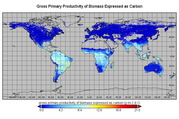
Global Monthly GPP from an Improved Light Use Efficiency Model, 1982-2016
National Aeronautics and Space Administration —
This dataset provides global monthly average gross primary productivity (GPP; g carbon/m2/d) modeled at 8 km spatial resolution for each of the 35 years from... -
Federal
ISLSCP II Ecosystem Rooting Depths
National Aeronautics and Space Administration —
The goal of this study was to predict the global distribution of plant rooting depths based on data about global aboveground vegetation structure and climate.... -
Federal
Biome-BGC: Terrestrial Ecosystem Process Model, Version 4.1.1
National Aeronautics and Space Administration —
Biome-BGC is a computer program that estimates fluxes and storage of energy, water, carbon, and nitrogen for the vegetation and soil components of terrestrial... -
Federal
ISLSCP II Total Plant-Available Soil Water Storage Capacity of the Rooting Zone
National Aeronautics and Space Administration —
This data set provides two estimates of the geographic distribution of the total plant-available soil water storage capacity of the rooting zone ("rooting zone water... -
Federal
NACP Site: Terrestrial Biosphere Model Output Data in Original Format
National Aeronautics and Space Administration —
This data set contains the original model output data submissions from the 24 terrestrial biosphere models (TBM) that participated in the North American Carbon... -
Federal
ATom: Merged Atmospheric Chemistry, Trace Gases, and Aerosols
National Aeronautics and Space Administration —
This dataset provides information on greenhouse gases and human-produced air pollution, including atmospheric concentrations of carbon dioxide (CO2), methane (CH4),... -
Federal
NWS Daily Climatology Data: 1990 (SNF)
National Aeronautics and Space Administration —
Weather data were collected by the National Weather Service in International Falls, Minnesota. International Falls is about 80 miles from the SNF, but the weather... -
Federal
NPP Grassland: Shortandy, Kazakhstan, 1977-1980, R1
National Aeronautics and Space Administration —
This data set provides two data files in text format (.txt). One file contains biomass measurements and cumulative ANPP calculations made between 1977 and 1980 on a... -
Federal
VEMAP 2: Annual Ecosystem Model Responses to U.S. Climate Change, 1994-2100
National Aeronautics and Space Administration —
The Vegetation-Ecosystem Modeling and Analysis Project (VEMAP) was a large, collaborative, multi-institutional, international effort whose goal was to evaluate the... -
Federal
Global Forest Ecosystem Structure and Function Data For Carbon Balance Research
National Aeronautics and Space Administration —
A comprehensive global database has been assembled to quantify CO2 fluxes and pathways across different levels of integration (from photosynthesis up to net ecosystem...

Official websites use .gov
A
.gov website belongs to an official government
organization in the United States.
Secure .gov websites use HTTPS
A
lock (
) or https:// means you’ve safely connected to
the .gov website. Share sensitive information only on official,
secure websites.