
-
Federal
BOREAS RSS-04 1994 Jack Pine Leaf Biochemistry and Modeled Spectra in the SSA
National Aeronautics and Space Administration —
The BOREAS RSS-04 team focused its efforts on deriving estimates of LAI and leaf chlorophyll and nitrogen concentrations from remotely sensed data for input into the... -
Federal
LBA-ECO LC-08 Soil, Vegetation, and Land Cover Maps for Brazil and South America
National Aeronautics and Space Administration —
This data set provides (1) soil maps for Brazil that are digital versions of the MAPA DE SOLOS DO BRASIL (EMBRAPA, 1981) classified at three levels of detail,... -
Federal
SHIFT: Wetland Spectra, Salinity, and Fractional Cover, Devereux Slough, CA, 2022
National Aeronautics and Space Administration —
This dataset includes field data, analysis code, and corresponding airborne imagery collected and generated during the 2022 NASA Surface Biology Geology (SBG) High... -
Federal
LBA-ECO CD-04 LAI Estimated from Photos, km 83 Tower Site, Tapajos National Forest
National Aeronautics and Space Administration —
This data set contains summary data for monthly leaf area index (LAI) and plant area index (PAI) at the km 83 Tower Site, in the Tapajos National Forest, Para,... -
Federal
SAFARI 2000 Stem and Canopy Characterization, Kalahari Transect, 1995-2000
National Aeronautics and Space Administration —
This data set provides species distribution, basal area, height, and crown cover of woody stems at 10 sites along the Kalahari Transect where a large gradient in both... -
Federal
LBA Regional Carbon in Live Vegetation, 0.5-degree (Olson)
National Aeronautics and Space Administration —
This data set is a subset of Olson et al. (1985, 2000) "Major World Ecosystem Complexes Ranked by Carbon in Live Vegetation." This subset was created for the study... -
Federal
Lund-Potsdam-Jena Wetland Hydrology and Methane DGV Model (LPJ-WHyMe v1.3.1)
National Aeronautics and Space Administration —
This model product provides the Fortran 77 source code for the Lund-Potsdam-Jena (LPJ) Wetland Hydrology and Methane Dynamic Global Vegetation Model (LPJ-WHyMe... -
Federal
Arctic Vegetation Plots at Atqasuk, Alaska, 1975, 2000, and 2010
National Aeronautics and Space Administration —
This data set provides vegetation species abundance data collected in 1975 from 60 sites on the Arctic Coastal Plain near Atqasuk, Alaska, as well as environmental... -
Federal
ABoVE: Ignitions, Burned Area, and Emissions of Fires in AK, YT, and NWT, 2001-2018
National Aeronautics and Space Administration —
This dataset provides estimates of daily burned area, carbon emissions, and uncertainty, and daily fire ignition locations for boreal fires in Alaska, U.S., and in... -
Federal
NPP Multi-Biome: Gridded Estimates for Selected Regions Worldwide, 1954-1998, R3
National Aeronautics and Space Administration —
This data set provides two data files (.csv format) containing gridded (0.5-degree) estimates of net primary productivity (NPP), elevation, temperature,... -
Federal
Delta-X: NUMAR Predictive Model for Marsh Accretion Rates and Chemical Properties
National Aeronautics and Space Administration —
This dataset provides input data and model code to run the Marsh Accretion Rates (NUMAR) process model used to predict soil accretion rates and chemical properties... -
Federal
Delta-X: In Situ Water Surface Reflectance across MRD, LA, USA, 2021, V3
National Aeronautics and Space Administration —
This dataset includes above water measurements of remote-sensing reflectance measured in situ at field sampling stations during the Delta-X 2021 field efforts.... -
Federal
A Global Database of Litterfall Mass and Litter Pool Carbon and Nutrients
National Aeronautics and Space Administration —
Measurement data of aboveground litterfall and littermass and litter carbon, nitrogen, and nutrient concentrations were extracted from 685 original literature sources... -
Federal
NACP Integrated Wildland and Cropland 30-m Fuel Characteristics Map, U.S.A., 2010
National Aeronautics and Space Administration —
The data set provides a 30-m comprehensive fuelbed characteristics map for both the wildland and cropland areas of the conterminous United States (CONUS) for 2010.... -
Federal
Global Soil Types, 0.5-Degree Grid (Modified Zobler)
National Aeronautics and Space Administration —
A global data set of soil types is available at 0.5-degree latitude by 0.5-degree longitude resolution. There are 106 soil units, based on Zobler?s (1986) assessment... -
Federal
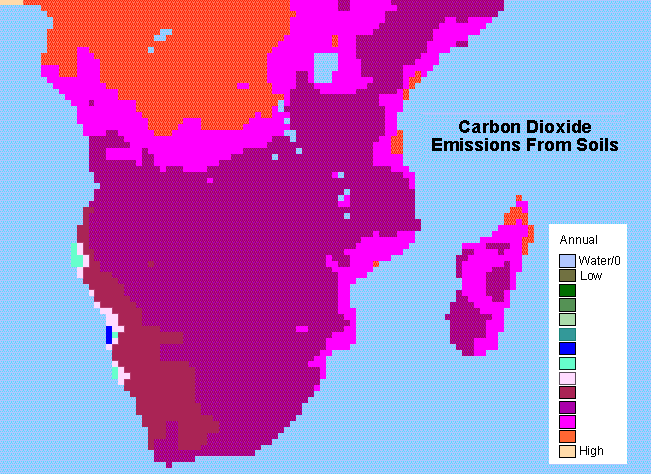
SAFARI 2000 Monthly and Annual CO2 Emissions from Soil, 0.5 Degree Grid
National Aeronautics and Space Administration —
The data set provides estimated monthly and annual soil CO2 emissions for southern Africa (the SAFARI 2000 project region). The calculated emissions are from the... -
Federal
SiB3 Modeled Global 1-degree Hourly Biosphere-Atmosphere Carbon Flux, 1998-2006
National Aeronautics and Space Administration —
The Simple Biosphere Model, Version 3 (SiB3) was used to produce a global data set of hourly carbon fluxes between the atmosphere and the terrestrial biosphere for... -
Federal
Ecosystem Demography Model: Scaling Vegetation Dynamics Across South America
National Aeronautics and Space Administration —
This model product contains the source code for the Ecosystem Demography Model (ED version 1.0) as well as model input and output data for a portion of South America... -
Federal
BOREAS Site and Area Geographic Coordinate Information
National Aeronautics and Space Administration —
In an effort to properly document the sites and areas where data were collected, personnel of the BOReal Ecosystem-Atmosphere Study (BOREAS) Information System...

Official websites use .gov
A
.gov website belongs to an official government
organization in the United States.
Secure .gov websites use HTTPS
A
lock (
) or https:// means you’ve safely connected to
the .gov website. Share sensitive information only on official,
secure websites.