
-
Federal
LBA-ECO LC-04 Satellite/Census-Based 5-Minute Land Use Data, Amazonia: 1980 and 1995
National Aeronautics and Space Administration —
Amazonia has been under considerable development pressure as croplands and pasture are established in areas formerly occupied by tropical forest and cerrado. Although... -
Federal
LBA Regional Organic Soil Carbon and Nitrogen Data (Zinke et al.)
National Aeronautics and Space Administration —
The data set contains a subset of a global organic soil carbon and nitrogen data set (Zinke et al. 1986). The subset was created for the study area of the Large Scale... -
Federal
SAFARI 2000 Global Burned Area Map, 1-km, Southern Africa, 2000
National Aeronautics and Space Administration —
The Global Burned Area 2000 initiative (GBA2000) was launched by the Global Vegetation Mapping Unit of the Joint Research Centre of the European Commission, in... -
Federal
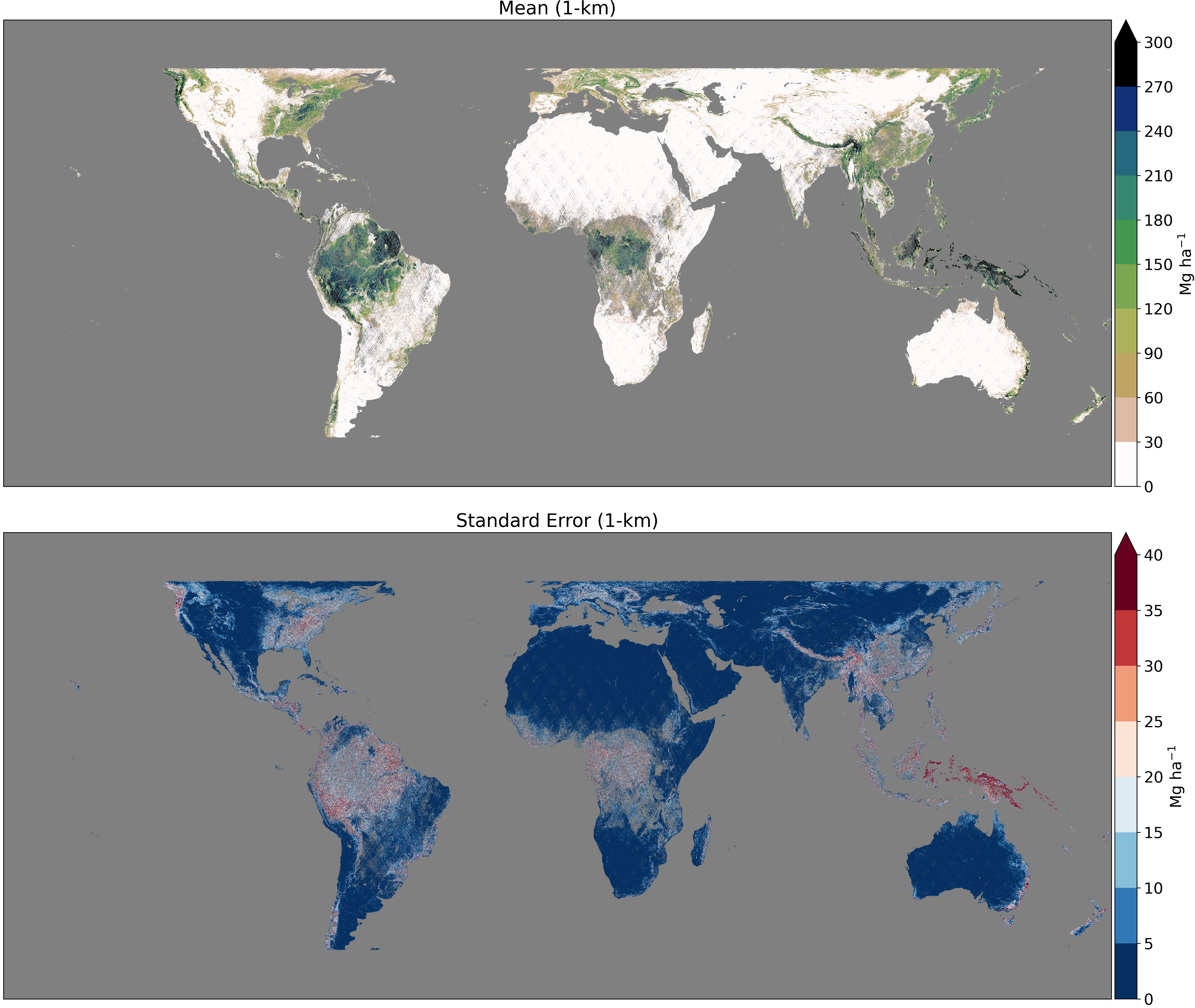
GEDI L4B Gridded Aboveground Biomass Density, Version 2.1
National Aeronautics and Space Administration —
This Global Ecosystem Dynamics Investigation (GEDI) L4B product provides 1 km x 1 km (1 km, hereafter) estimates of mean aboveground biomass density (AGBD) based on... -
Federal
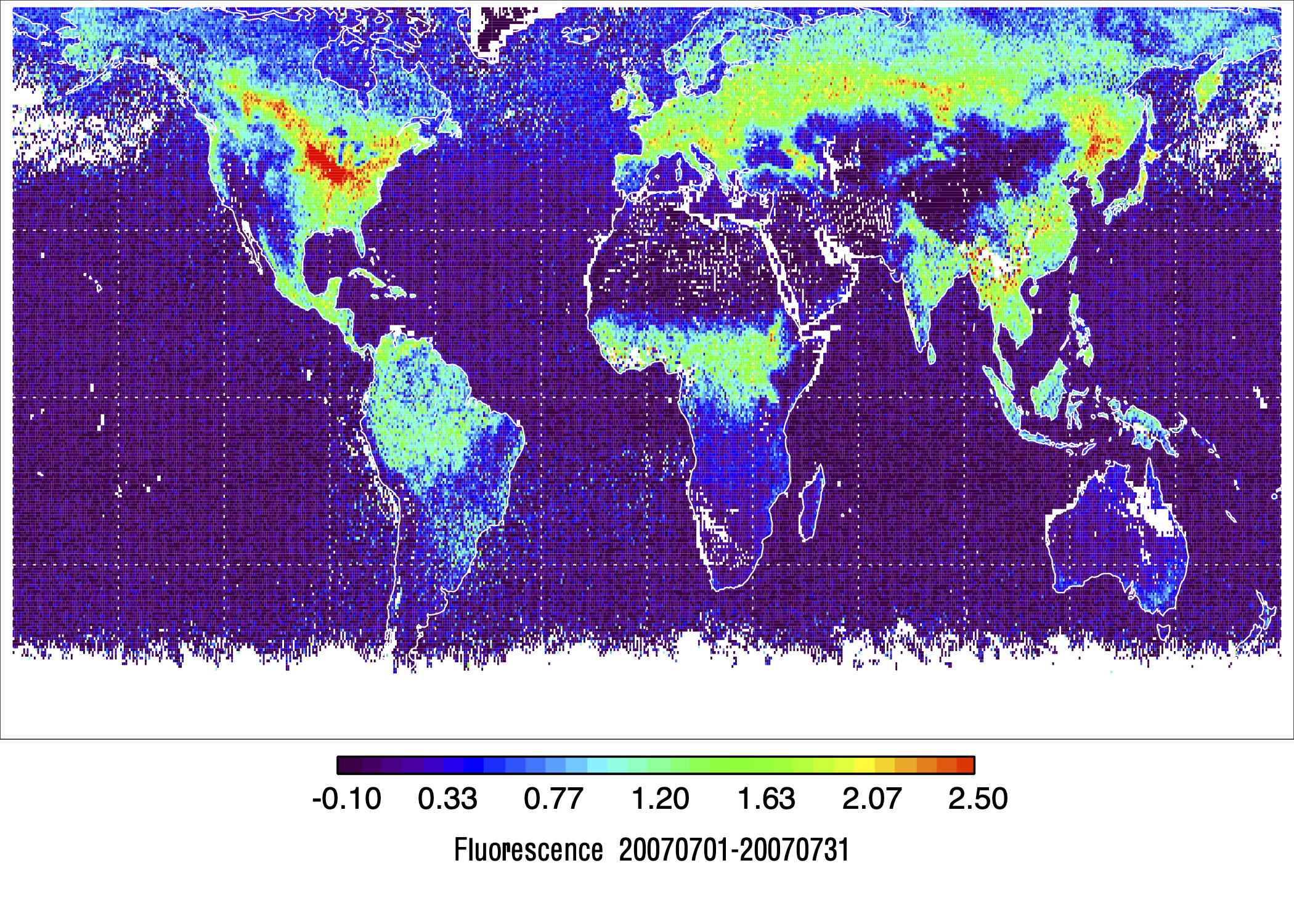
L2 Daily Solar-Induced Fluorescence (SIF) from MetOp-A GOME-2, 2007-2018, V2
National Aeronautics and Space Administration —
This dataset provides Level 2 (L2) Solar-Induced Fluorescence (SIF) of chlorophyll estimates derived from the Global Ozone Monitoring Experiment 2 (GOME-2) instrument... -
Federal
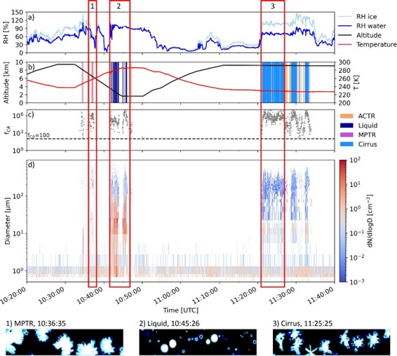
ATom: Development of Cloud Indicator Algorithm Using Airborne Observations from CAPS
National Aeronautics and Space Administration —
This dataset is the basis for the development of the Cloud Indicator, a novel algorithm that automatically detects and classifies measurement periods inside clouds.... -
Federal
GEDI L4C Footprint Level Waveform Structural Complexity Index, Version 2
National Aeronautics and Space Administration —
This dataset contains Global Ecosystem Dynamics Investigation (GEDI) Level 4C (L4C) Version 2 predictions of the Waveform Structural Complexity Index (WSCI) and... -
Federal
Global Soil Profile Data (ISRIC-WISE)
National Aeronautics and Space Administration —
The International Soil Reference and Information Centre-World Inventory of Soil Emission Potentials (ISRIC-WISE) international soil profile data set consists of a... -
Federal
SAFARI 2000 Estimated BVOC Emissions for Southern African Land Cover Types
National Aeronautics and Space Administration —
Improved vegetation distribution and emission data for Africa south of the equator were developed for the Southern African Regional Science Initiative (SAFARI 2000)... -
Federal
VEMAP 2: U.S. Monthly Climate, 1895-1993, Version 2
National Aeronautics and Space Administration —
The Vegetation/Ecosystem Modeling and Analysis Project (VEMAP) Phase 2 has developed a data set of ~100-year gridded monthly and daily time series of climate for the... -
Federal
GEDI L4B Gridded Aboveground Biomass Density, Version 2
National Aeronautics and Space Administration —
This Global Ecosystem Dynamics Investigation (GEDI) L4B product provides 1 km x 1 km (1 km, hereafter) estimates of mean aboveground biomass density (AGBD) based on... -
Federal
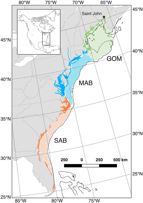
Mean Annual Fluxes of Carbon in Coastal Ecosystems of Eastern North America
National Aeronautics and Space Administration —
This dataset contains best estimates and uncertainties for mean annual fluxes of inorganic, organic, and total (organic + inorganic) carbon in tidal wetlands,... -
Federal
LBA Regional Land Cover from AVHRR, 1-Degree, 1987 (Defries and Townshend)
National Aeronautics and Space Administration —
This data set consists of a subset for the study area of the Large Scale Biosphere-Atmosphere Experiment in Amazonia (LBA) in South America (i.e., longitude 85 deg to... -
Federal
ATom: Cloud and Coarse Aerosol Measurements from CAPS Instrument, 2016-2018
National Aeronautics and Space Administration —
This dataset contains cloud type and coarse aerosol contents measured by the University of Vienna's second-generation Cloud Aerosol and Precipitation Spectrometer... -
Federal
Digital Elevation Models for the Global Change Research Wetland, Maryland, USA, 2016
National Aeronautics and Space Administration —
This dataset contains four alternative digital elevation models (DEMs) at 1 m resolution and model performance statistical metrics for the Global Change Research... -
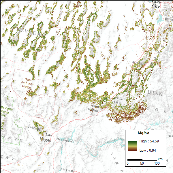
Federal
CMS: Pinyon-Juniper Forest Live Aboveground Biomass, Great Basin, USA, 2000-2016
National Aeronautics and Space Administration —
This dataset provides annual maps of live aboveground tree biomass (Mg/ha) for pinyon-juniper forests across the Great Basin of the Western USA for the years... -
Federal
LBA-ECO TG-07 Forest Soil P, C, and N Pools, km 83 Site, Tapajos National Forest
National Aeronautics and Space Administration —
This data set reports phosphorus (P), carbon (C), and nitrogen (N) nutrient pool concentrations for forest soils and roots and P pool concentrations for forest floor... -
Federal
LBA Regional Land Cover from AVHRR, 1-km, Version 1.2 (IGBP)
National Aeronautics and Space Administration —
The data set consists of a LBA study area subset of the IGBP DISCover Data Set. The DISCover data set is one data set contained within the Global Land Cover... -
Federal
AVIRIS-3 L1B Calibrated Radiance, Facility Instrument Collection
National Aeronautics and Space Administration —
This dataset contains Level 1B (L1B) calibrated radiance images as well as observational geometry and illumination parameters from the Airborne Visible / Infrared... -
Federal
Lund-Potsdam-Jena Wetland Hydrology and Methane DGV Model (LPJ-WHyMe v1.3.1)
National Aeronautics and Space Administration —
This model product provides the Fortran 77 source code for the Lund-Potsdam-Jena (LPJ) Wetland Hydrology and Methane Dynamic Global Vegetation Model (LPJ-WHyMe...

Official websites use .gov
A
.gov website belongs to an official government
organization in the United States.
Secure .gov websites use HTTPS
A
lock (
) or https:// means you’ve safely connected to
the .gov website. Share sensitive information only on official,
secure websites.