
-
Federal
NACP Regional: National Greenhouse Gas Inventories and Aggregated Gridded Model Data
National Aeronautics and Space Administration —
This data set provides two products that were derived from the recently published North American Carbon Program (NACP) Regional Synthesis 1-degree terrestrial... -
Federal
CMS: Forest Biomass and Productivity, 1-degree and 5-km, Conterminous US, 2005
National Aeronautics and Space Administration —
Notice: This data set and guide were updated on June 30, 2014 to correct an error in the reported units. The data values were not changed.Spatially-gridded estimates... -
Federal
NPP Cropland: Gridded Estimates For the Central USA, 1982-1996, R1
National Aeronautics and Space Administration —
This data set contains a single data file (.csv format) that provides gridded values of net primary productivity (NPP) for cropland in eight counties in the central... -
Federal
LiDAR Derived Forest Aboveground Biomass Maps, Northwestern USA, 2002-2016
National Aeronautics and Space Administration —
This dataset provides maps of aboveground forest biomass (AGB) of living trees and standing dead trees in Mg/ha across portions of Northwestern United States,... -
Federal
Wetland Salinity Maps of Select Estuary Sites in the United States, 2020
National Aeronautics and Space Administration —
This dataset provides gridded average annual wetland salinity concentrations in practical salinity units (PSU) at 30-meter resolution within 24 coastal estuary sites... -
Federal
Monthly Climate Data for Selected USGS HCDN Sites, 1951-1990, R1
National Aeronautics and Space Administration —
Time series of monthly minimum and maximum temperature, precipitation, and potential evapotranspiration were derived for 1,469 watersheds in the conterminous United... -
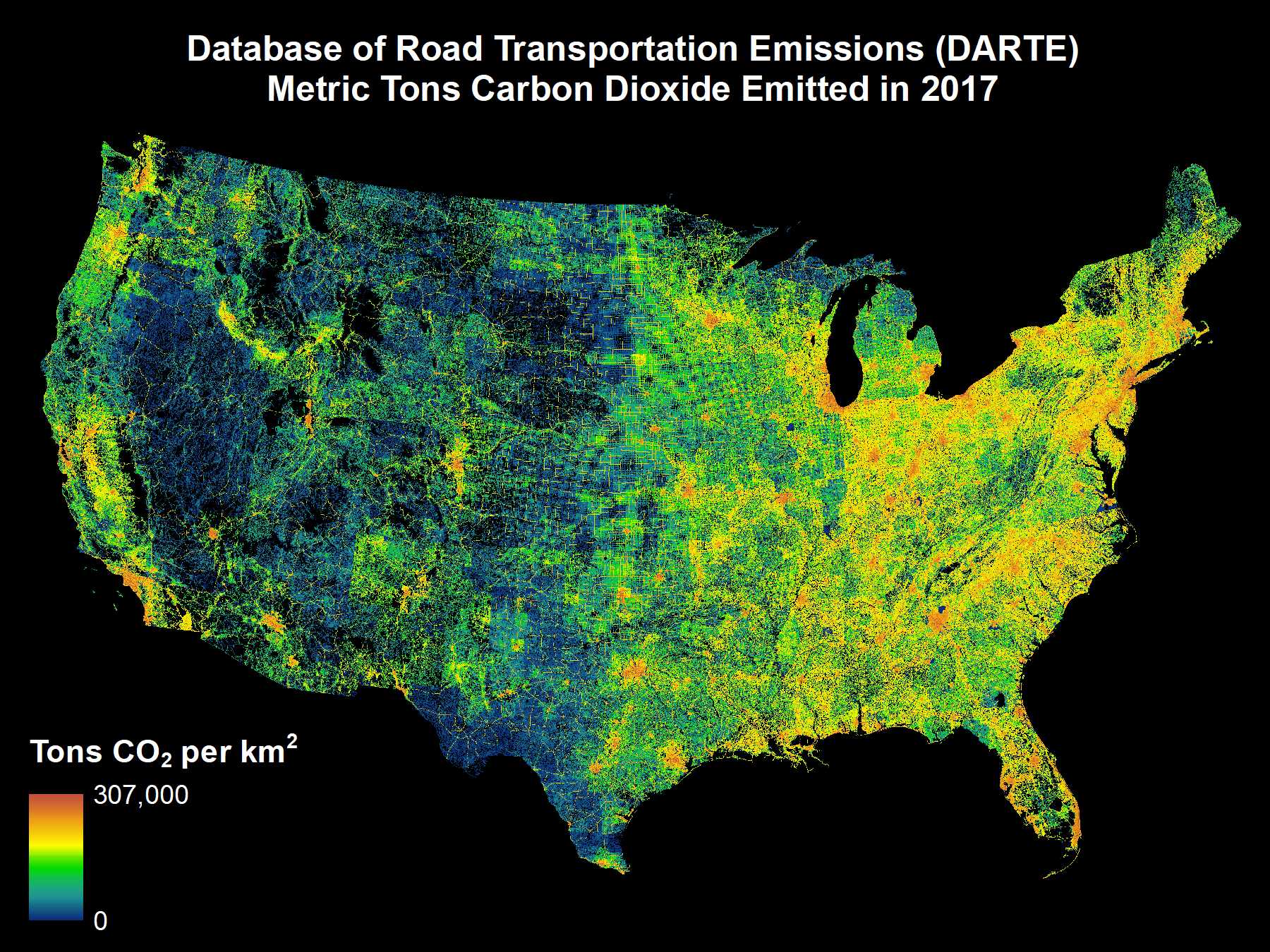
Federal
DARTE Annual On-road CO2 Emissions on a 1-km Grid, Conterminous USA, V2, 1980-2017
National Aeronautics and Space Administration —
This data set provides a 38-year, 1-km resolution inventory of annual on-road CO2 emissions for the conterminous United States based on roadway-level vehicle traffic... -
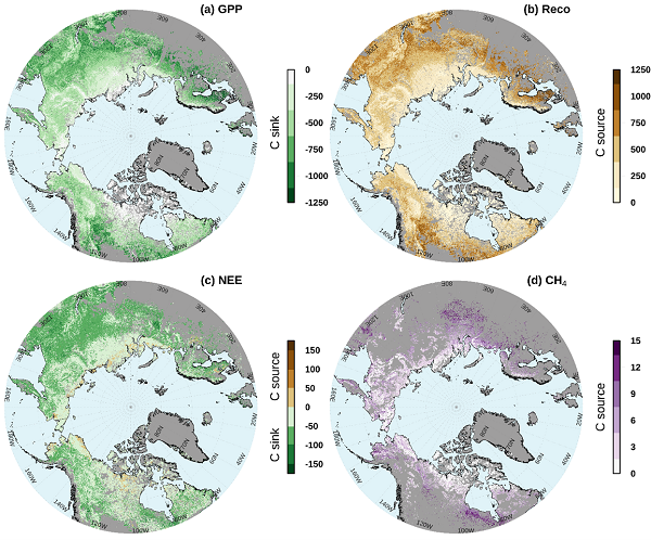
Federal
Gridded CO2 and CH4 Flux Estimates for pan-Arctic and Boreal Regions, 2003-2015
National Aeronautics and Space Administration —
This dataset provides gridded estimates of gross primary productivity (GPP), ecosystem respiration (Reco), net ecosystem CO2 exchange (NEE = Reco - GPP), and methane... -
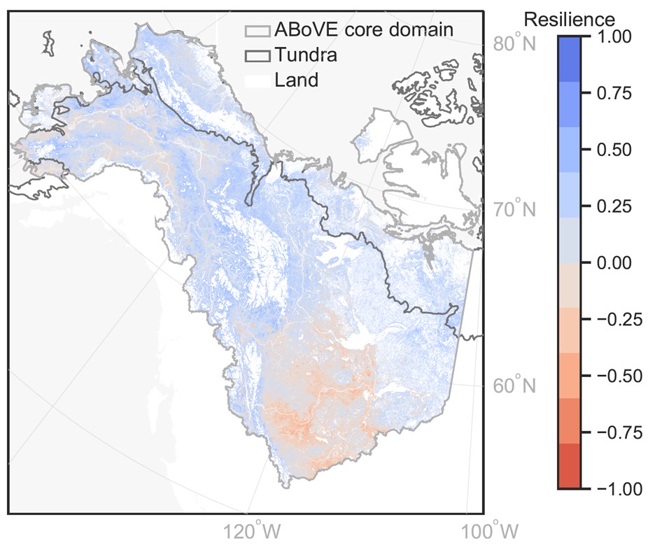
Federal
MODIS-derived Annual Vegetation Resilience, 2000-2019
National Aeronautics and Space Administration —
This dataset provides estimates of vegetation resilience in the Arctic Boreal Vulnerability Experiment (ABoVE) core domain at annual time steps for 2000-2019 and at... -
Federal
LUH2-ISIMIP2b Harmonized Global Land Use for the Years 2015-2100
National Aeronautics and Space Administration —
This dataset provides 0.25-degree gridded, global, annual estimates of fractional land use and land cover patterns for the period 2015-2100, designed to support the... -
Federal
LiDAR Derived Biomass, Canopy Height, and Cover for New England Region, USA, 2015
National Aeronautics and Space Administration —
This dataset provides 30 m gridded estimates of aboveground biomass density (AGBD), forest canopy height, and tree canopy coverage for the New England Region of the... -
Federal
Vulcan: High-Resolution Hourly Fossil Fuel CO2 Emissions in USA, 2010-2015, Version 3
National Aeronautics and Space Administration —
The Vulcan version 3.0 hourly dataset quantifies hourly emissions at a 1-km resolution for the 2010-2015 time period. Estimates are provided of hourly carbon dioxide... -
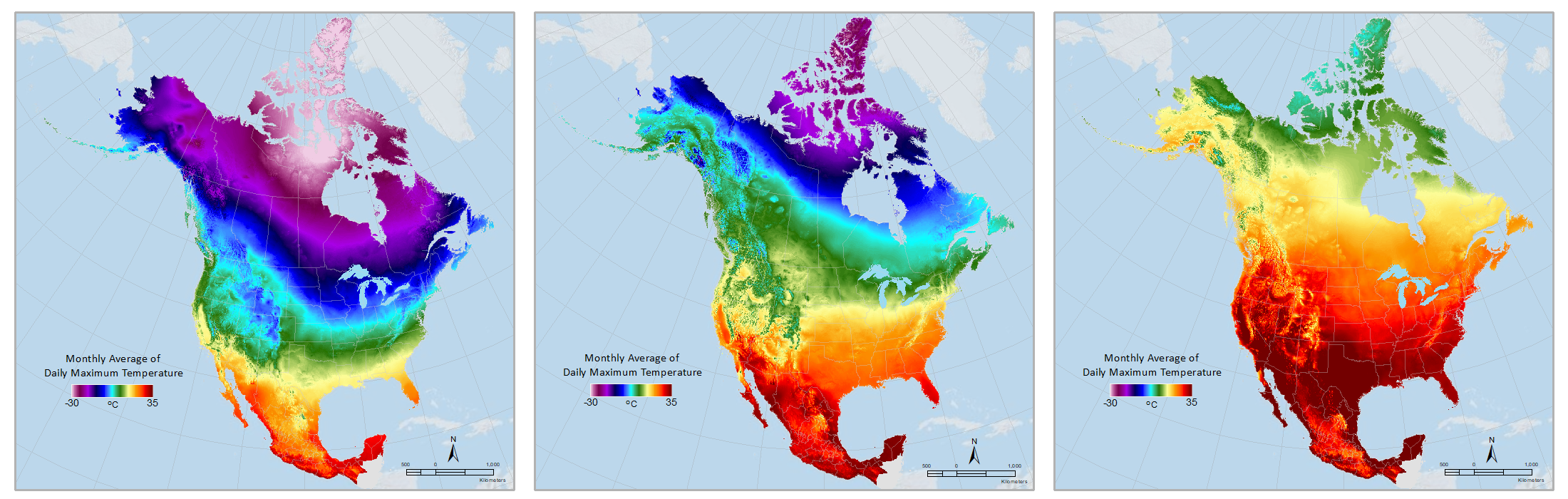
Federal
Daymet: Monthly Climate Summaries on a 1-km Grid for North America, Version 4 R1
National Aeronautics and Space Administration —
This dataset provides Daymet Version 4 R1 monthly climate summaries derived from Daymet Version 4 R1 daily data at a 1 km x 1 km spatial resolution for five Daymet... -
Federal
Remote Sensing Derived Topsoil and Agricultural Economic Losses, Midwestern USA
National Aeronautics and Space Administration —
This dataset provides estimates of topsoil loss and economic loss associated with decreased crop productivity resulting from topsoil loss at county- and state-levels... -
Federal
VEMAP 1: U.S. Climate Change Scenarios Based on Models with Increased CO2
National Aeronautics and Space Administration —
The Vegetation/Ecosystem Modeling and Analysis Project (VEMAP) is an ongoing multiinstitutional, international effort addressing the response of biogeography and... -
Federal
VEMAP 2: U.S. Monthly Climate, 1895-1993, Version 2
National Aeronautics and Space Administration —
The Vegetation/Ecosystem Modeling and Analysis Project (VEMAP) Phase 2 has developed a data set of ~100-year gridded monthly and daily time series of climate for the... -
Federal
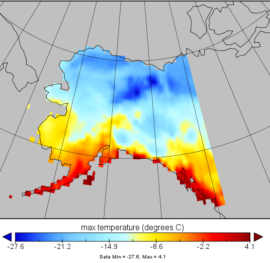
VEMAP 2: Monthly Historical and Future Climate Data, Alaska, USA
National Aeronautics and Space Administration —
This data set provides the results of the development of The Vegetation/Ecosystem Modeling and Analysis Project (VEMAP) Phase 2 transient climate change scenarios for... -
Federal
VEMAP 2: U.S. Annual Climate, 1895-1993
National Aeronautics and Space Administration —
The Vegetation/Ecosystem Modeling and Analysis Project (VEMAP) Phase 2 has developed a data set of ~100-year gridded annual, monthly, and daily time series of climate...

Official websites use .gov
A
.gov website belongs to an official government
organization in the United States.
Secure .gov websites use HTTPS
A
lock (
) or https:// means you’ve safely connected to
the .gov website. Share sensitive information only on official,
secure websites.