
-
Federal
RLC State and Regional Boundaries for the Former Soviet Union
National Aeronautics and Space Administration —
This data set of state and regional boundaries was derived from the 1:3 million scale administrative boundaries (ESRI, 1998) for the land area of the Former Soviet... -
Federal
LBA-ECO CD-06 Physical, Political, and Hydrologic Maps, Ji-Parana River Basin, Brazil
National Aeronautics and Space Administration —
This data set contains physical, hydrologic, political, demographic, and societal maps for the Ji-Parana River Basin, in the state of Rondonia, Brazil. These data... -
Federal
Sources of Methane Emissions (Vista-CA), State of California, USA
National Aeronautics and Space Administration —
This dataset provides spatial data products with identified and organized locations of potential methane (CH4) emitting facilities and infrastructure spanning the... -
Federal
Vulcan: High-Resolution Annual Fossil Fuel CO2 Emissions in USA, 2010-2015, Version 3
National Aeronautics and Space Administration —
The Vulcan version 3.0 annual dataset provides estimates of annual carbon dioxide (CO2) emissions from the combustion of fossil fuels (FF) and CO2 emissions from... -
Federal
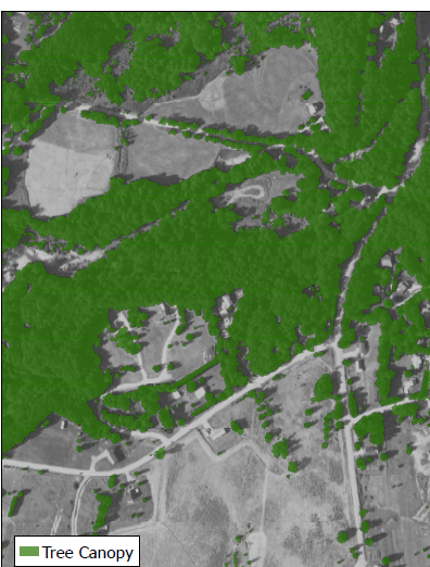
CMS: Tree Canopy Cover at 0.5-meter resolution, Vermont, 2016
National Aeronautics and Space Administration —
This dataset contains estimates of tree canopy cover presence at high resolution (0.5m) across the state of Vermont for 2016 in Cloud-Optimized GeoTIFF (*.tif)... -
Federal
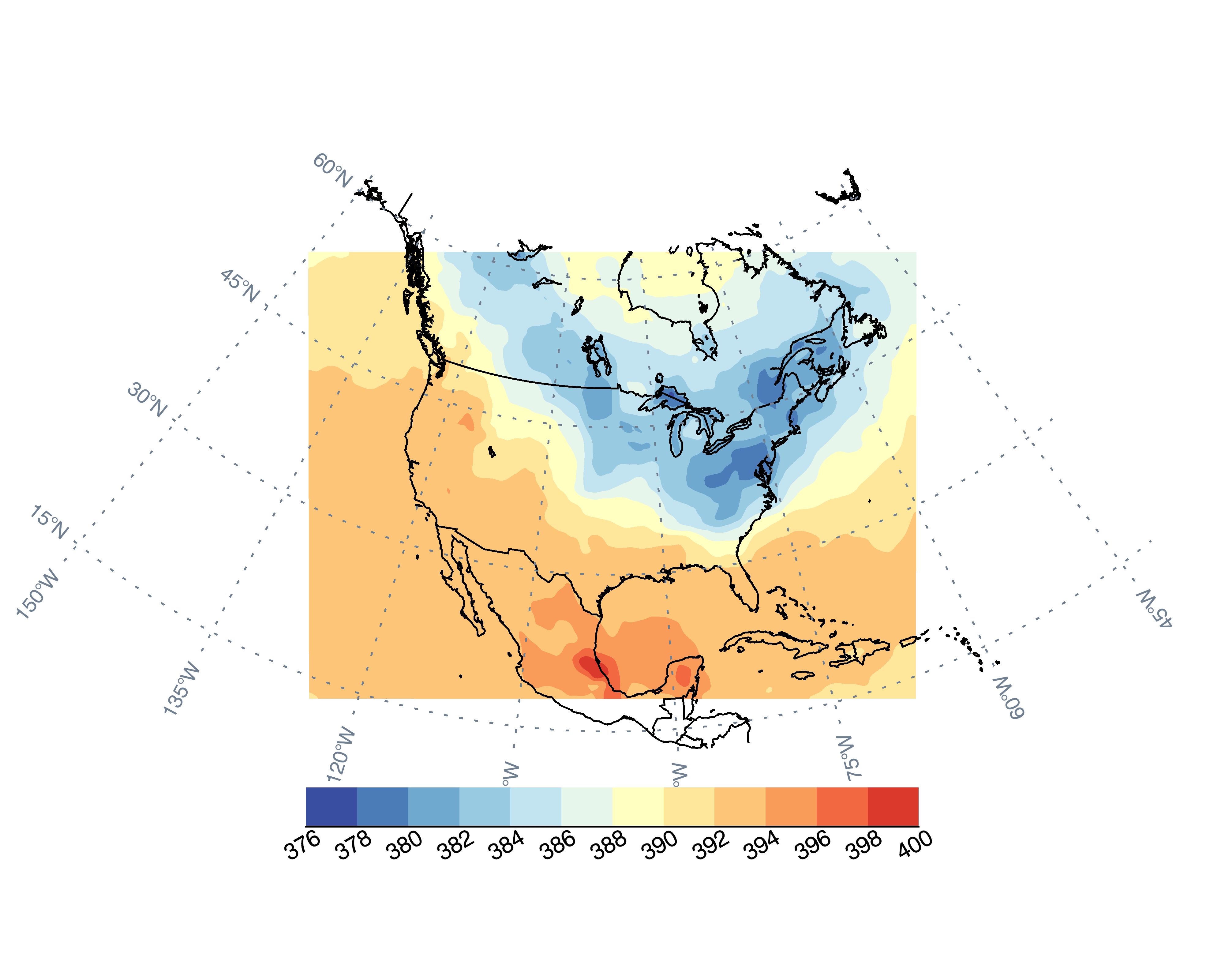
CMS: Hourly Carbon Dioxide Estimated Using the WRF Model, North America, 2010
National Aeronautics and Space Administration —
This data set contains estimated hourly CO2 atmospheric mole fractions and meteorological observations over North America for the year 2010 at a horizontal grid... -
Federal
ACT-America: Profile-based Planetary Boundary Layer Heights, Eastern USA
National Aeronautics and Space Administration —
This dataset provides profile-based estimates of the height to the top of the planetary boundary layer (PBL), also known as the atmospheric boundary layer (ABL), in... -
Federal
NACP Regional: National Greenhouse Gas Inventories and Aggregated Gridded Model Data
National Aeronautics and Space Administration —
This data set provides two products that were derived from the recently published North American Carbon Program (NACP) Regional Synthesis 1-degree terrestrial... -
Federal
LBA-ECO CD-02 Carbon and Oxygen Isotopes in Atmospheric CO2 in the Amazon: 1999-2004
National Aeronautics and Space Administration —
This data set reports carbon and oxygen stable isotope ratios of atmospheric carbon dioxide (CO2) collected at several forest and pasture sites and in the free... -
Federal
LBA Regional Boundary for the Legal Amazon of Brazil, 8-km
National Aeronautics and Space Administration —
The Legal Amazon of Brazil is defined by law to include the states of Acre, Amapá, Amazonas, Pará, Rondônia, Roraima, Mato Grosso, Maranhão, and Tocantins [Fundãcao... -
Federal
NACP MCI: CO2 Flux from Inversion Modeling, Upper Midwest Region, USA, 2007
National Aeronautics and Space Administration —
This data set provides estimates of Net Ecosystem Exchange (NEE) flux for the U.S. Upper Midwest at 0.5-degree resolution for the year 2007. Estimates were produced... -
Federal
LBA-ECO LC-09 Natural, Infrastructure, and Boundary Features, Amazonian Sites, Brazil
National Aeronautics and Space Administration —
This data set includes 16 zipped archives of shapefiles of cities, rivers and streams, roads, and study area boundaries of several Amazonian study sites: Altamira,... -
Federal
NACP Aboveground Biomass and Carbon Baseline Data, V.2 (NBCD 2000), U.S.A., 2000
National Aeronautics and Space Administration —
The NBCD 2000 (National Biomass and Carbon Dataset for the Year 2000) data set provides a high-resolution (30 m) map of year-2000 baseline estimates of basal area-... -
Federal
NACP MCI: CO2 Emissions Inventory, Upper Midwest Region, USA., 2007
National Aeronautics and Space Administration —
This data set provides a bottom-up CO2 emissions inventory for the mid-continent region of the United States for the year 2007. The study was undertaken as part of... -
Federal
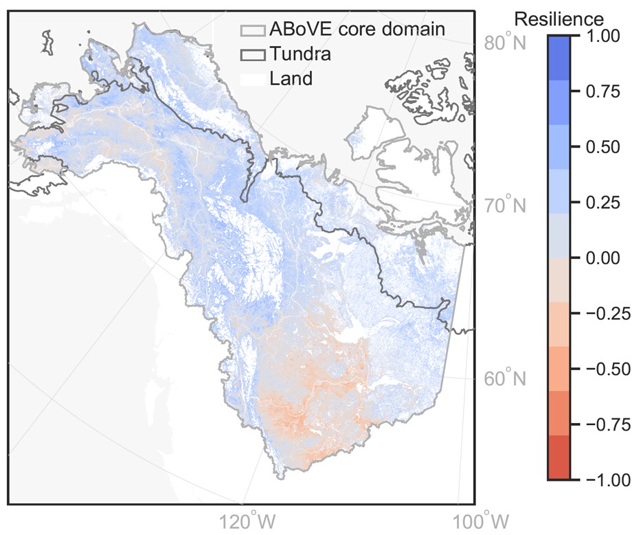
MODIS-derived Annual Vegetation Resilience, 2000-2019
National Aeronautics and Space Administration —
This dataset provides estimates of vegetation resilience in the Arctic Boreal Vulnerability Experiment (ABoVE) core domain at annual time steps for 2000-2019 and at... -
Federal
ISLSCP II Sea Surface Temperature
National Aeronautics and Space Administration —
Sea surface temperature (SST) is an important indicator of the state of the earth climate system as well as a key variable in the coupling between the atmosphere and... -
Federal
BASIN TCP Stable Isotope Composition of CO2 in Terrestrial Ecosystems
National Aeronautics and Space Administration —
This data set reports stable isotope ratio data of CO2 (13C/12C and 18O/16O) associated with photosynthetic and respiratory exchanges across the biosphere-atmosphere...

Official websites use .gov
A
.gov website belongs to an official government
organization in the United States.
Secure .gov websites use HTTPS
A
lock (
) or https:// means you’ve safely connected to
the .gov website. Share sensitive information only on official,
secure websites.