
-
Federal
Global Historical Climatology Network, 1753-1990
National Aeronautics and Space Administration —
This data set contains monthly temperature, precipitation, sea-level pressure, and station-pressure data for thousands of meteorological stations worldwide. The... -
Federal
LBA Regional Global Historical Climatology Network, V. 1, 1832-1990
National Aeronautics and Space Administration —
This data set consists of a subset of the Global Historical Climatology Network (GHCN) Version 1 database for the study area of the Large Scale Biosphere-Atmosphere... -
Federal
BOREAS/AES Campbell Scientific 15-minute Surface Meteorological Data: 1996
National Aeronautics and Space Administration —
Canadian AES personnel collected data related to surface and atmospheric meteorological conditions over the BOREAS Region. This data set contains 15 minute... -
Federal
ACT-America: Profile-based Planetary Boundary Layer Heights, Eastern USA
National Aeronautics and Space Administration —
This dataset provides profile-based estimates of the height to the top of the planetary boundary layer (PBL), also known as the atmospheric boundary layer (ABL), in... -
Federal
ABoVE: Permafrost Measurements and Distribution Across the Y-K Delta, Alaska, 2016
National Aeronautics and Space Administration —
This dataset provides field observations of thaw depth and dominant vegetation types, a LiDAR-derived elevation map, and permafrost distribution and probability maps... -
Federal
SAFARI 2000 Global Historical Climatology Network, V. 1, 1874-1990
National Aeronautics and Space Administration —
This data set consists of a southern African subset of the Global Historical Climatology Network (GHCN) Version 1 database. All stations with the following bounding... -
Federal
ISLSCP II Northern Hemisphere Monthly Snow Cover Extent
National Aeronautics and Space Administration —
This ISLSCP data set is derived from the National Snow and Ice Data Center (NSIDC) Northern Hemisphere EASE-Grid Weekly Snow Cover and Sea Ice Extent product which... -
Federal
LBA-ECO ND-11 Soil Water Pressure and Flow Measurements under Tree Crops
National Aeronautics and Space Administration —
This data set contains information that can be used to examine water fluxes in soils beneath tree crops in an Amazonian agroforest. The data consists of repeated... -
Federal
BOREAS/AES Campbell Scientific 15-minute Surface Meteorological Data: 1995
National Aeronautics and Space Administration —
Canadian AES personnel collected data related to surface and atmospheric meteorological conditions over the BOREAS Region. This data set contains 15 minute... -
Federal
BOREAS AES Canadian Hourly and Daily Surface Meteorological Data, R1
National Aeronautics and Space Administration —
This data set contains hourly and daily meteorological data from 23 meteorological stations across Canada from January 1975 to January 1997. The surface meteorology... -
Federal
BOREAS/AES Campbell Scientific 15-minute Surface Meteorological Data: 1994
National Aeronautics and Space Administration —
Canadian AES personnel collected data related to surface and atmospheric meteorological conditions over the BOREAS Region. This data set contains 15 minute... -
Federal
Pre-LBA ISLSCP Initiative I Data
National Aeronautics and Space Administration —
This data set contains hydrology, soils, radiation, cloud, and vegetation data from the International Satellite Land Surface Climatology Project (ISLSCP) Initiative... -
Federal
SAFARI 2000 SeaWiFS Images for the Southern African Region, 1999-2001
National Aeronautics and Space Administration —
This data set contains Sea-viewing Wide Field-of-view Sensor (SeaWiFS) imagery for the southern African region. These images are Level-1a swaths of the southern... -
Federal
SAFARI 2000 TOMS Aerosol Index Data, Southern Africa, Dry Season 2000
National Aeronautics and Space Administration —
Daily Aerosol Index (AI) data from Earth Probe (EP) Total Ozone Mapping Spectrometer (TOMS) for the period of August 12-September 25, 2000 were processed and provided... -
Federal
Resilience of Coastal Wetlands to Sea Level Rise, CONUS, 1996-2100
National Aeronautics and Space Administration —
This dataset provides information about the resilience of tidal wetlands to sea-level rise under three scenarios of global change. With rising seas, regularly... -
Federal
Tidal Wetlands Soil Organic Carbon and Estuarine Characteristics, USA, 1972-2015
National Aeronautics and Space Administration —
This dataset provides a synthesis of soil organic carbon (SOC) estimates and a variety of other environmental information from tidal wetlands within estuaries in the... -
Federal
Surface Meteorology Data: NCDC (FIFE)
National Aeronautics and Space Administration —
The NOAA Regional Surface Data - 1989 (NCDC) Data Set contains hourly surface meteorological data for the FIFE area. Though the measurements presented in this data... -
Federal
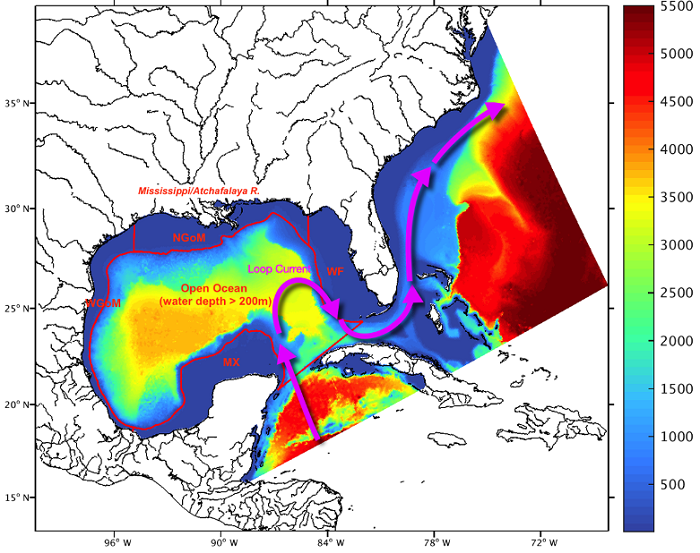
CMS: Simulated Physical-Biogeochemical Data, SABGOM Model, Gulf of America, 2005-2010
National Aeronautics and Space Administration —
This dataset contains monthly mean ocean surface physical and biogeochemical data for the Gulf of America simulated by the South Atlantic Bight and Gulf of America... -
Federal
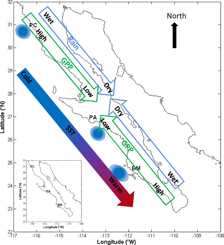
CMS: MODIS GPP, fPAR, and SST, and ENSO Index, Baja California, Mexico, 2000-2013
National Aeronautics and Space Administration —
This data set provides data for MODIS-derived (1) gross primary productivity (GPP) for the years 2000-2010, (2) fraction of photosynthetically active radiation (fPAR)...

Official websites use .gov
A
.gov website belongs to an official government
organization in the United States.
Secure .gov websites use HTTPS
A
lock (
) or https:// means you’ve safely connected to
the .gov website. Share sensitive information only on official,
secure websites.