
-
Federal
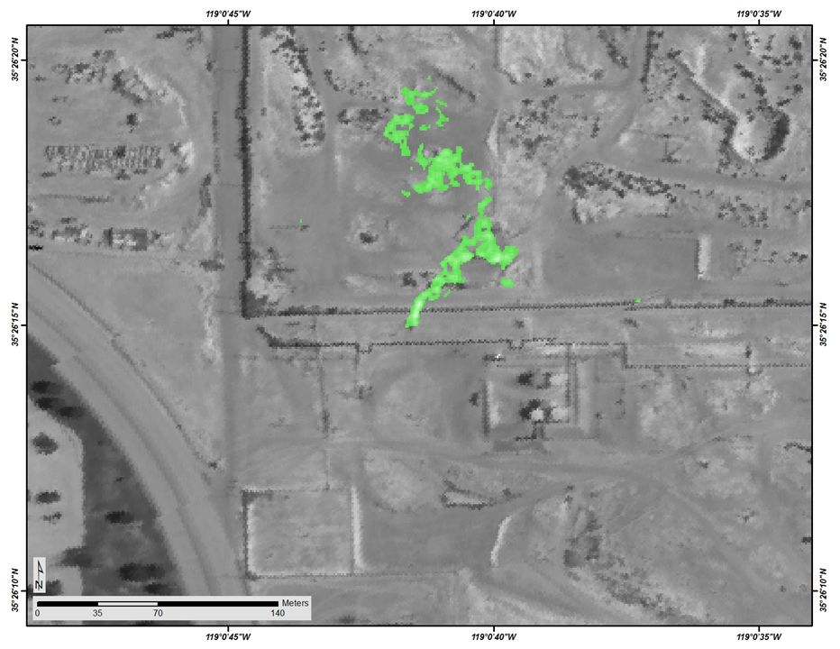
SHIFT: Wetland Spectra, Salinity, and Fractional Cover, Devereux Slough, CA, 2022
National Aeronautics and Space Administration —
This dataset includes field data, analysis code, and corresponding airborne imagery collected and generated during the 2022 NASA Surface Biology Geology (SBG) High... -
Federal
LBA Regional Organic Soil Carbon and Nitrogen Data (Zinke et al.)
National Aeronautics and Space Administration —
The data set contains a subset of a global organic soil carbon and nitrogen data set (Zinke et al. 1986). The subset was created for the study area of the Large Scale... -
Federal
LBA-ECO CD-06 Biogeochemistry of Ji-Parana River and Tributaries, Brazil: 1999-2003
National Aeronautics and Space Administration —
This data set provides spatially extensive and temporally intensive surveys of the river biogeochemistry of the Ji-Parana River Basin in Western Amazonia, Rondonia,... -
Federal
A Compilation of Global Soil Microbial Biomass Carbon, Nitrogen, and Phosphorus Data
National Aeronautics and Space Administration —
This data set provides the concentrations of soil microbial biomass carbon (C), nitrogen (N) and phosphorus (P), soil organic carbon, total nitrogen, and total... -
Federal
SAFARI 2000 Woody Vegetation Characteristics of Kalahari and Skukuza Sites
National Aeronautics and Space Administration —
This data set contains species composition, basal area, height, and crown cover of all woody plants at six sites along the Kalahari Transect visited in February-March... -
Federal
LBA-ECO ND-01 Reflectance and Biophysical Measures, Grass Pastures: Rondonia, Brazil
National Aeronautics and Space Administration —
This data set provides the results of spectral reflectance (350 to 2,500 nm at 1-nm increments) and biophysical measurements on grass pastures in eight cattle ranches... -
Federal
GEDI L4C Footprint Level Waveform Structural Complexity Index, Version 2
National Aeronautics and Space Administration —
This dataset contains Global Ecosystem Dynamics Investigation (GEDI) Level 4C (L4C) Version 2 predictions of the Waveform Structural Complexity Index (WSCI) and... -
Federal
Soil Hydraulic Conductivity Data (FIFE)
National Aeronautics and Space Administration —
The Soil Hydraulic Conductivity Data Set contains soil hydraulic conductivity, matric flux potential, and soil depth data collected during the 1989 FIFE soil... -
Federal
LBA-ECO ND-11 Soil Properties of Forested Headwater Catchments, Mato Grosso, Brazil
National Aeronautics and Space Administration —
The northwestern region of Mato Grosso State consists of complex landscapes due to ongoing geomorphologic activity that contributes to the occurrence of different... -
Federal
LBA-ECO CD-10 H2O Profiles at km 67 Tower Site, Tapajos National Forest
National Aeronautics and Space Administration —
This data set reports vertical profiles of H2O vapor concentrations measured at the Para Western (Santarem) - km 67, Primary Forest Tower Site (Figure 1). This site... -
Federal
LBA-ECO CD-09 Soil and Vegetation Characteristics, Tapajos National Forest, Brazil
National Aeronautics and Space Administration —
This data set reports the results of soil and vegetation surveys at four distinct areas within the Tapajos National Forest (TNF), 50 to 100 km south of Santarem,... -
Federal
Longwave-infrared spectral imagery in support of COMEX, 2014
National Aeronautics and Space Administration —
This dataset provides calibrated at-sensor radiance, retrieved surface brightness temperature, and adaptive coherence estimator (ACE) detection imagery of methane,... -
Federal
Eddy Corr. Surface Flux: UK (FIFE)
National Aeronautics and Space Administration —
Surface flux measurements were made at selected sites within the FIFE study area. Each surface flux station was capable of measuring the fluxes of net radiation,... -
Federal
Boundary Layer Heights: LIDAR (FIFE)
National Aeronautics and Space Administration —
The Volume Imaging LIDAR (VIL) system of the University of Wisconsin, operated during FIFE and all LIDAR return signals measured at a 90 degree elevation angle were... -
Federal
BOREAS HYD-08 1994 Gravimetric Moss Moisture Data
National Aeronautics and Space Administration —
The BOREAS HYD-08 team made measurements of surface hydrological processes that were collected at the NSA OBS Tower Flux site in 1994 and at Joey Lake, Manitoba, to... -
Federal
BOREAS HYD-08 Throughfall Data
National Aeronautics and Space Administration —
The BOREAS HYD-08 team made measurements of surface hydrological processes at the SSA (1996) and NSA OBS (1994) Tower Flux sites, supporting its research into point... -
Federal
BOREAS HYD-08 1996 Gravimetric Moss Moisture Data
National Aeronautics and Space Administration —
The BOREAS HYD-08 team made measurements of surface hydrological processes that were collected at the SSA-OBS Tower Flux site in 1996 to support its research into... -
Federal
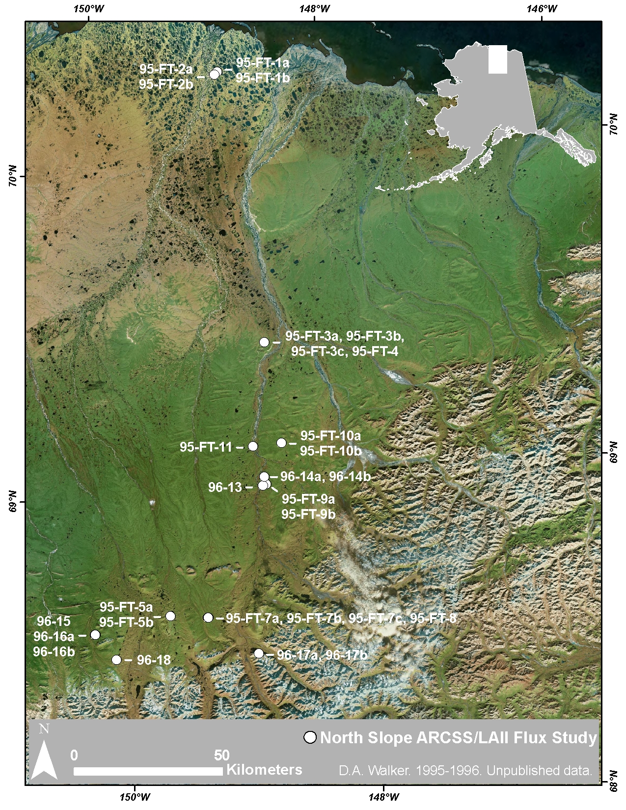
Arctic Vegetation Plots at ARCSS/LAII Flux Sites, North Slope, Alaska, 1995-1996
National Aeronautics and Space Administration —
This dataset provides vegetation cover and environmental plot and soil data collected at flux tower sites of the North Slope Arctic System Science/Land-Atmosphere-Ice... -
Federal
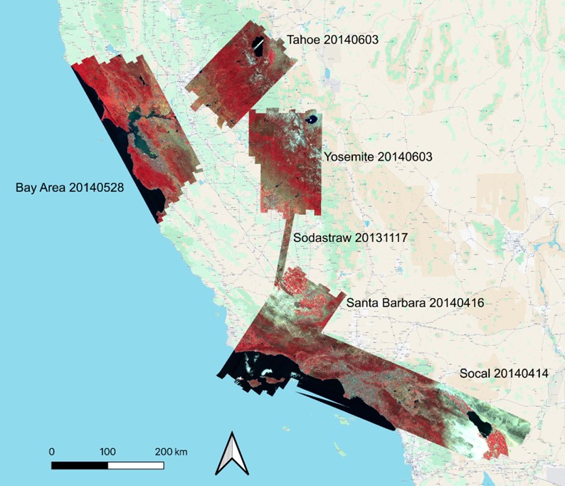
WDTS: AVIRIS-Classic L2B Corrected and Georectified Surface Reflectance, 2013-2018
National Aeronautics and Space Administration —
This dataset includes Level-2 (L2) surface reflectance imagery from the AVIRIS-Classic instrument collected for NASA's Western Diversity Time Series Project over...

Official websites use .gov
A
.gov website belongs to an official government
organization in the United States.
Secure .gov websites use HTTPS
A
lock (
) or https:// means you’ve safely connected to
the .gov website. Share sensitive information only on official,
secure websites.