
-
Federal
LBA-ECO LC-03 Hypsography, Rivers, Roads, and DEM, Four Areas across Brazilian Amazon recent views
National Aeronautics and Space Administration —
This data set provides four related spatial data products for four study areas across the Brazilian Amazon: Manaus, Amazonas; Tapajos National Forest, Para Western... -
Federal
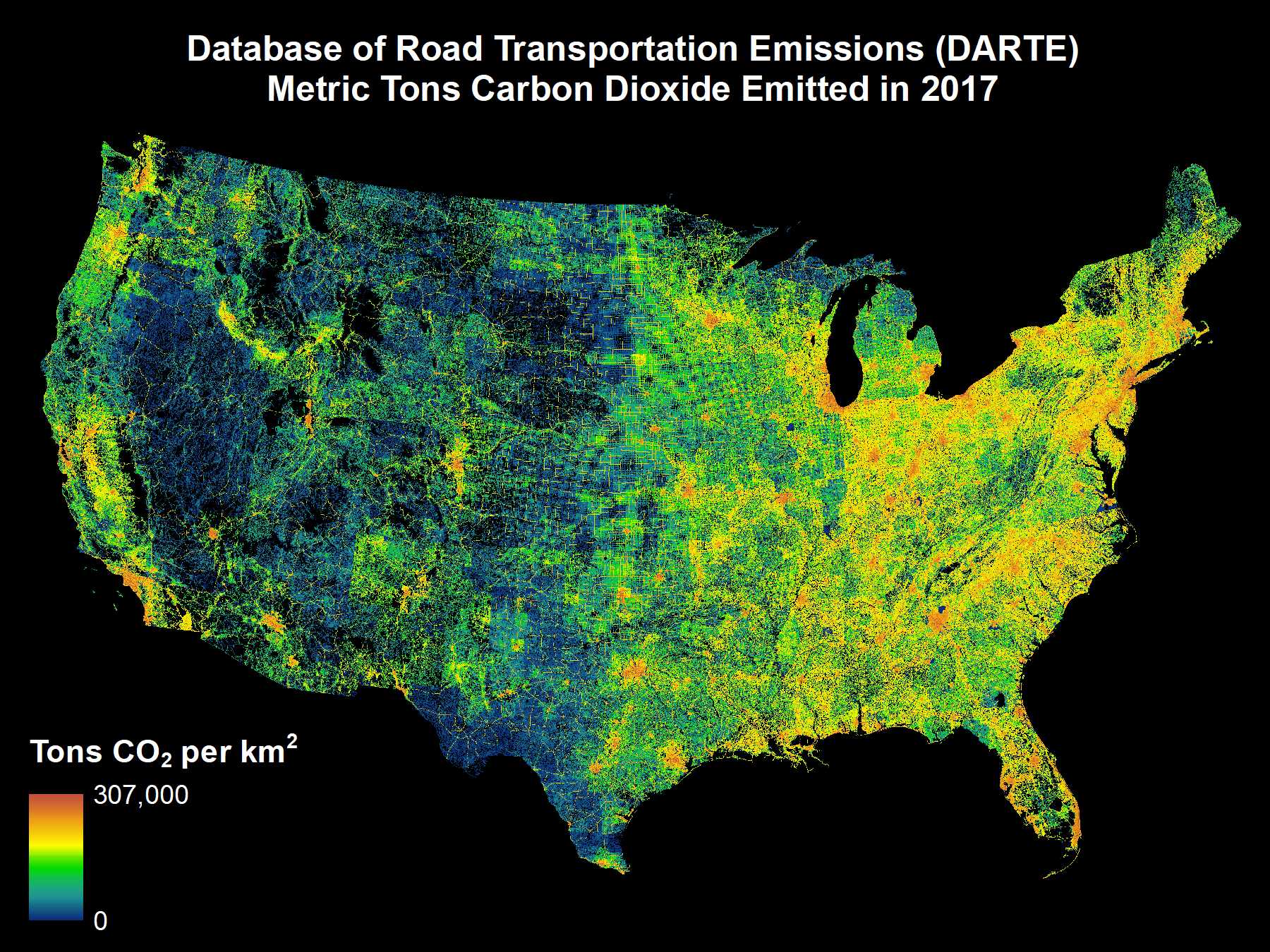
DARTE Annual On-road CO2 Emissions on a 1-km Grid, Conterminous USA, V2, 1980-2017 recent views
National Aeronautics and Space Administration —
This data set provides a 38-year, 1-km resolution inventory of annual on-road CO2 emissions for the conterminous United States based on roadway-level vehicle traffic... -
Federal
LBA-ECO ND-04 Secondary Forest Carbon and Nutrient Stocks, Central Amazonia, Brazil recent views
National Aeronautics and Space Administration —
This data set reports the carbon and nutrient stocks of above-ground vegetation and soil pools at three locations where post-pasture secondary forest recovery ranged... -
Federal
LBA-ECO LC-14 Modeled Deforestation Scenarios, Amazon Basin: 2002-2050 recent views
National Aeronautics and Space Administration —
This data set provides the results of the two modeled scenarios for future patterns of deforestation across the Amazon Basin from 2002 to 2050. This larger defined... -
Federal
LBA-ECO ND-11 Forest Damage Following Reduced Impact Logging, NW Mato Grosso, Brazil recent views
National Aeronautics and Space Administration —
Data were collected in the logging concession at the Fazenda Rohsamar in the municipality of Juruena in northwestern Mato Grosso. Estimates of damage associated with... -
Federal
LBA-ECO ND-04 Secondary Forest Recovery, Structure, and LAI, Central Amazonia, Brazil recent views
National Aeronautics and Space Administration —
This data set reports measurements of the canopy and structure of secondary forests regenerating from abandoned pastures. These secondary forests are located in the... -
Federal
LBA-ECO LC-21 Foliar Nutrients, Logged Areas, Tapajos Forest, Para, Brazil: 2003 recent views
National Aeronautics and Space Administration —
This data set provides measurements for foliar nutrients from logging blocks in the Tapajos National Forest, Para Western Santarem, Brazil. Data are included for... -
Federal
LBA-ECO LC-01 City, Community, and Road Maps, Northern Ecuadorian Amazon: 1990-2002 recent views
National Aeronautics and Space Administration —
This data set contains the boundaries of the four major cities in the Northern Ecuadorian Amazon, the locations of primary communities in the colonist settlement... -
Federal
LBA-ECO LC-23 Characterization of Vegetation Fire Dynamics for Brazil: 2001-2003 NGDA recent views
National Aeronautics and Space Administration —
Satellite fire detection was determined from two sensors, the Advanced Very High Resolution Radiometer (AVHRR) on NOAA-12 and the Moderate Resolution Imaging... -
Federal
LBA-ECO LC-13 GIS Coverages of Logged Areas, Cauaxi, Para, Brazil: 1996, 1998 recent views
National Aeronautics and Space Administration —
This data set contains GIS coverage constructed from measurements taken of four logged areas in Cauaxi, Para, Brazil. Logged areas were selectively harvested either... -
Federal
LBA-ECO LC-09 Natural, Infrastructure, and Boundary Features, Amazonian Sites, Brazil recent views
National Aeronautics and Space Administration —
This data set includes 16 zipped archives of shapefiles of cities, rivers and streams, roads, and study area boundaries of several Amazonian study sites: Altamira,... -
Federal
LBA-ECO LC-13 GIS Coverages of Logged Areas, Tapajos Forest, Para, Brazil: 1996, 1998 recent views
National Aeronautics and Space Administration —
This data set contains GIS coverages constructed from measurements taken of logged areas in the Tapajos National Forest region of Para, Brazil in 1996 and 1998 (Asner... -
Federal
LBA-ECO LC-13 GIS Coverages of Logged Areas, Juruena, Mato Grosso, Brazil: 2002 recent views
National Aeronautics and Space Administration —
This data set contains GIS coverages constructed from measurements taken of logged areas in Juruena, Mato Grosso. Classes include roads, skids trails, tree crowns,... -
Federal
RLC Selected Infrastructure Data for the Former Soviet Union, 1993 recent views
National Aeronautics and Space Administration —
This data set consists of roads, drainage, railroads, utilities, and population center information in readily usable vector format for the land area of the Former... -
Federal
LBA-ECO LC-08 Passive Ground-based Fire Data, Para and Mato Grosso Brazil: 2001-2002 recent views
National Aeronautics and Space Administration —
This data set reports observations of fires in the vicinity of Maraba, Para, Brazil, from November 3-5th, 2001, and in Mato Grosso, Brazil, between Cuiaba and Alta... -
Federal
LBA-ECO CD-08 Tropical Forest Ecosystem Respiration, Manaus, Brazil recent views
National Aeronautics and Space Administration —
Leaf, live wood (tree stem), and soil respiration were measured along with additional environmental factors over a 1-yr period in a Central Amazon terra firme forest... -
Federal
LBA-ECO CD-06 Physical, Political, and Hydrologic Maps, Ji-Parana River Basin, Brazil recent views
National Aeronautics and Space Administration —
This data set contains physical, hydrologic, political, demographic, and societal maps for the Ji-Parana River Basin, in the state of Rondonia, Brazil. These data... -
Federal
LBA-ECO LC-24 Historical Roads of the Legal Amazon: 1968-1993 recent views
National Aeronautics and Space Administration —
This data set contains ESRI shapefiles of historical roads (basin-wide federal and state roads) in nine Brazilian states for the Legal Amazon: Amazonas, Para, Acre,... -
Federal
Arctic Vegetation Plots, Prudhoe Bay ArcSEES Road Study, Lake Colleen, Alaska, 2014 recent views
National Aeronautics and Space Administration —
This dataset provides environmental, soil, and vegetation data collected from study plots in the vicinity of Lake Colleen off the Spine Road at Prudhoe Bay, Alaska,...

Official websites use .gov
A
.gov website belongs to an official government
organization in the United States.
Secure .gov websites use HTTPS
A
lock (
) or https:// means you’ve safely connected to
the .gov website. Share sensitive information only on official,
secure websites.