

18 datasets found for "Provinces"
-
Federal
LBA-ECO LC-01 Northern Ecuadorian Amazon Household Surveys, Summary Results: 1999
National Aeronautics and Space Administration —
This data set reports summary statistics from socioeconomic and demographic surveys administered to the male and female heads of household on 767 farm plots. The... -
Federal
SAFARI 2000 Pre- and Post-fire Reflectance near Kaoma, Zambia, Dry Season 2000
National Aeronautics and Space Administration —
The main goal of this study was to analyze the possibility of estimating combustion completeness based on fire-induced spectral reflectance changes of surface... -
Federal
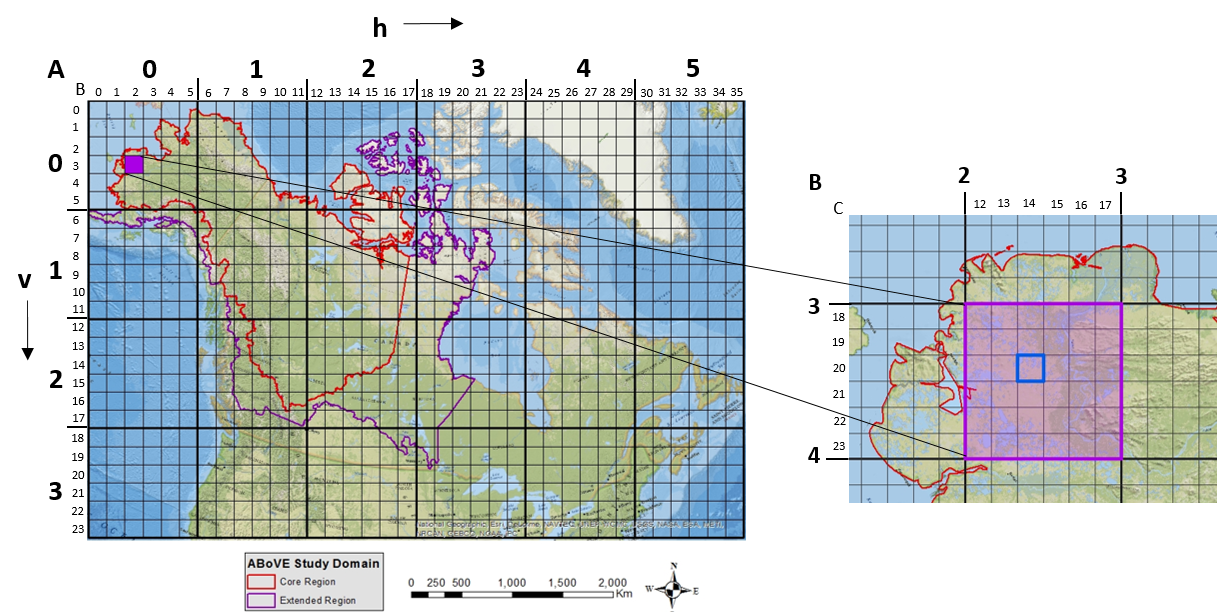
ABoVE: Study Domain and Standard Reference Grids
National Aeronautics and Space Administration —
The Arctic - Boreal Vulnerability Experiment (ABoVE) has developed two standardized spatial data products to expedite coordination of research activities and to... -
Federal
BOREAS/AES MARS-II 15-minute Surface Meteorological Data: 1994
National Aeronautics and Space Administration —
Canadian AES personnel collected several data sets related to surface and atmospheric meteorological conditions over the BOREAS region. This data set contains... -
Federal
SAFARI 2000 Daily Rainfall Totals for Mongu, Zambia, 1999-2002
National Aeronautics and Space Administration —
This data set contains daily rainfall totals (mm) from Mongu, in the Western Province of Zambia. The data were collected with a British standard 5 inch diameter rain... -
Federal
ABoVE: Study Domain and Standard Reference Grids, Version 2
National Aeronautics and Space Administration —
The Arctic - Boreal Vulnerability Experiment (ABoVE) has developed two standardized spatial data products to expedite coordination of research activities and to... -
Federal
BOREAS Regional Soils Data in Raster Format and AEAC Projection
National Aeronautics and Space Administration —
This data set was gridded by BORIS staff from a vector data set received from Canadian Soil Information System (CanSIS). The original data came in two parts that... -
Federal
SAFARI 2000 Surface Irradiance Measurements, Mongu Tower Site, Zambia, 2000-2002
National Aeronautics and Space Administration —
This data set contains the top-of-canopy irradiance in the shortwave (0.3-2.8 micron) and photosynthetically active radiation (PAR; 0.4-0.7 micron) wavebands... -
Federal
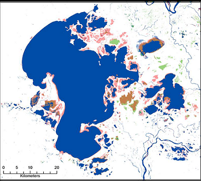
ABoVE: Surface Water Extent, Boreal and Tundra Regions, North America, 1991-2011
National Aeronautics and Space Administration —
This data set provides the location and extent of surface water (open water not including vegetated wetlands) for the entire Boreal and Tundra regions of North... -
Federal
Arctic Vegetation Plots at Umiat, North Slope, Alaska, 1951
National Aeronautics and Space Administration —
This data set provides vegetation cover and plot data collected during the periods of July and August, 1951, from 51 stands (areas of homogeneous vegetation... -
Federal
Arctic Tundra Flux Study in the Kuparuk River Basin (Alaska), 1994-1996
National Aeronautics and Space Administration —
CO2 and water vapor fluxes and ecosystem characteristics were measured at 24 sites along a 317-km transect from the Arctic coast to the latitudinal treeline in Alaska... -
Federal
BOREAS TGB-05 Fire History of Manitoba 1980 to 1991 in Raster Format
National Aeronautics and Space Administration —
This raster format data set covers the province of Manitoba. The data were gridded into the AEAC projection from the original vector data. The original vector data... -
Federal
BOREAS TGB-05 Fire History of Manitoba 1980 to 1991 in Vector Format
National Aeronautics and Space Administration —
This vector format data set covers the province of Manitoba and was produced by Forestry Canada from hand-drawn boundaries of fires on photocopies of 1:250,000 scale... -
Federal
CMS: Mangrove Canopy Height from High-resolution Stereo Image Pairs, Mozambique, 2012
National Aeronautics and Space Administration —
This data set provides canopy height estimates for mangrove forests at 0.6 x 0.6 m resolution in three study sites located in southeastern Mozambique, Africa: two... -
Federal
BOREAS CanSIS Regional Soils Data in Vector Format, V2
National Aeronautics and Space Administration —
This data set contains soils data from the Canada Soil Information System (CanSIS) in ESRI Shapefile format for the provinces of Saskatchewan and Manitoba. They are...
18 datasets found for "Provinces"