
-
Federal
NACP North American Forest Dynamics Project: Forest Disturbance and Regrowth Data
National Aeronautics and Space Administration —
This data set provides the results of time-series analyses of Landsat imagery for 55 selected forested sites across the conterminous U.S.A. The output is a pair of... -
Federal
SHIFT: AVIRIS-NG Full-Resolution True Color Images
National Aeronautics and Space Administration —
This dataset holds full-resolution 3-band (true color) imagery acquired by NASA's Airborne Visible / Infrared Imaging Spectrometer-Next Generation (AVIRIS-NG)... -
Federal
Global Data Set of Derived Soil Properties, 0.5-Degree Grid (ISRIC-WISE)
National Aeronautics and Space Administration —
The World Inventory of Soil Emission Potentials (WISE) database currently contains data for over 4300 soil profiles collected mostly between 1950 and 1995. This... -
Federal
NACP Aboveground Biomass and Carbon Baseline Data, V.2 (NBCD 2000), U.S.A., 2000
National Aeronautics and Space Administration —
The NBCD 2000 (National Biomass and Carbon Dataset for the Year 2000) data set provides a high-resolution (30 m) map of year-2000 baseline estimates of basal area-... -
Federal
LBA-ECO LC-14 Modeled Deforestation Scenarios, Amazon Basin: 2002-2050
National Aeronautics and Space Administration —
This data set provides the results of the two modeled scenarios for future patterns of deforestation across the Amazon Basin from 2002 to 2050. This larger defined... -
Federal
LUH1: Harmonized Global Land Use for Years 1500-2100, V1
National Aeronautics and Space Administration —
These data represent fractional land use and land cover patterns annually for the years 1500 - 2100 for the globe at 0.5-degree (~50-km) spatial resolution. Land use... -
Federal
Leaf Area Index Maps at 30-m Resolution, VALERI Site, Larose, Canada
National Aeronautics and Space Administration —
This data set provide local LAI maps for the Larose (Ontario) site in Canada. These derived maps may also be useful for validating other LAI maps over this same site... -
Federal
Land Use and Cover Maps from Landsat, Mawas, Central Kalimantan, Indonesia, 1994-2019
National Aeronautics and Space Administration —
This dataset contains annual land use/cover (LUC) maps at 30 m resolution across Mawas, Central Kalimantan, Indonesia. There are six files, each representing a five-... -
Federal
BOREAS RSS-08 Snow Maps Derived from Landsat TM Imagery
National Aeronautics and Space Administration —
The BOREAS RSS-08 team utilized Landsat TM images to perform mapping of snow extent over the SSA. This data set consists of two Landsat TM images which were used to... -
Federal
BOREAS RSS-10 TOMS Circumpolar One-Degree PAR Images
National Aeronautics and Space Administration —
The BOREAS RSS-10 team investigated the magnitude of daily, seasonal, and yearly variations of PAR from ground and satellite observations. This data set contains... -
Federal
BOREAS RSS-18 Level 1B AVIRIS At-Sensor Radiance Imagery
National Aeronautics and Space Administration —
This dataset holds Level 1B (L1B) radiance data collected by the AVIRIS-Classic instrument near Prince Albert, Saskatchewan, Canada, on August 14, 1996. This imagery... -
Federal
LBA-ECO CD-06 Water Balance of the Ji-Parana River Basin, Brazil: 1995-1996
National Aeronautics and Space Administration —
This data set provides simulated minimum, average, and maximum monthly rainfall, potential evapotranspiration, water deficit, and water surplus values for the Ji-... -
Federal
AVIRIS-3 L2A Orthocorrected Surface Reflectance, Facility Instrument Collection
National Aeronautics and Space Administration —
This dataset contains Level 2A (L2A) surface reflectance images from the Airborne Visible / Infrared Imaging Spectrometer-3 (AVIRIS-3) instrument. This is the NASA... -
Federal
BOREAS RSS-15 SIR-C and TM Biomass and Landcover Maps of the NSA and SSA
National Aeronautics and Space Administration —
As part of BOREAS, the RSS-15 team conducted an investigation using SIR-C , X-SAR and Landsat TM data for estimating total above-ground dry biomass for the SSA and... -
Federal
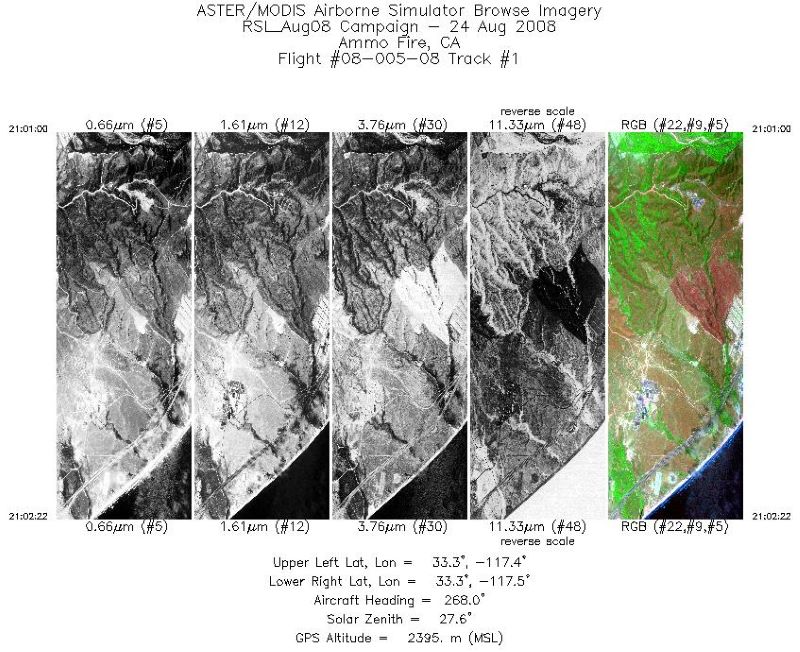
MASTER: California Fire-Burn Area Emergency Response, California, August 2008
National Aeronautics and Space Administration —
This dataset includes Level 1B (L1B) data products from the MODIS/ASTER Airborne Simulator (MASTER) instrument. The spectral data were collected during four flights... -
Federal
LBA-ECO LC-09 Land Cover Transitions Maps for Study Sites in Para, Brazil: 1970-2001
National Aeronautics and Space Administration —
This data set includes classified land cover transition maps at 30-m resolution derived from Landsat TM, MSS, ETM+ imagery and aerial photos of Altamira, Santarem,... -
Federal
CMS: Forest Inventory and Biophysical Measurements, Para, Brazil, 2012-2014
National Aeronautics and Space Administration —
This data set provides measurements for diameter at breast height (DBH), commercial tree height, and total tree height for forest inventories taken at the Fazenda... -
Federal
MASTER: California Fires, California, November 2007
National Aeronautics and Space Administration —
This dataset includes Level 1B (L1B) data products from the MODIS/ASTER Airborne Simulator (MASTER) instrument. The spectral data were collected during six flights... -
Federal
BOREAS RSS-14 Level-3 Gridded Radiometer and Satellite Surface Radiation Images
National Aeronautics and Space Administration —
The BOREAS RSS-14 team collected and processed GOES-7 and -8 images of the BOREAS region as part of their effort to characterize the incoming, reflected and emitted...

Official websites use .gov
A
.gov website belongs to an official government
organization in the United States.
Secure .gov websites use HTTPS
A
lock (
) or https:// means you’ve safely connected to
the .gov website. Share sensitive information only on official,
secure websites.