

14 datasets found for "Infrastructure"
-
Federal
NACP Site: Terrestrial Biosphere Model Output Data in Original Format
National Aeronautics and Space Administration —
This data set contains the original model output data submissions from the 24 terrestrial biosphere models (TBM) that participated in the North American Carbon... -
Federal
Methane Plumes Derived from AVIRIS-NG over Point Sources across California, 2016-2017
National Aeronautics and Space Administration —
This dataset provides maps of methane (CH4) plumes along flight lines over identified methane point-source emitting infrastructure across the State of California, USA... -
Federal
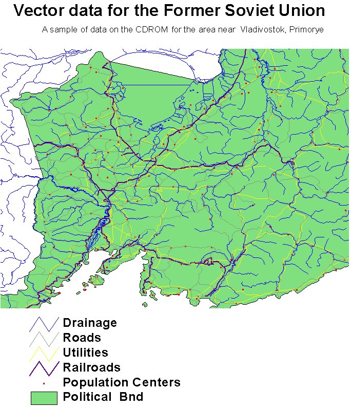
RLC Selected Infrastructure Data for the Former Soviet Union, 1993
National Aeronautics and Space Administration —
This data set consists of roads, drainage, railroads, utilities, and population center information in readily usable vector format for the land area of the Former... -
Federal
Sources of Methane Emissions (Vista-LA), South Coast Air Basin, California, USA
National Aeronautics and Space Administration —
This data set provides spatial data products with identified and classified locations of potential methane (CH4) emitting facilities and infrastructure in the South... -
Federal
LBA-ECO CD-06 Physical, Political, and Hydrologic Maps, Ji-Parana River Basin, Brazil
National Aeronautics and Space Administration —
This data set contains physical, hydrologic, political, demographic, and societal maps for the Ji-Parana River Basin, in the state of Rondonia, Brazil. These data... -
Federal
Northern and Mid-Latitude Soil Database, Version 1, R1
National Aeronautics and Space Administration —
The U.S. Department of Agriculture, Agriculture and Agri-Food Canada, the Russian Academy of Agricultural Sciences, the University of Copenhagen Institute of... -
Federal
Geobotanical and Impact Map Collection for Prudhoe Bay Oilfield, Alaska, 1972-2010
National Aeronautics and Space Administration —
This data set provides a collection of maps of geoecological characteristics of areas within the Beechey Point quadrangle near Prudhoe Bay on the North slope of... -
Federal
Vulcan: High-Resolution Annual Fossil Fuel CO2 Emissions in USA, 2010-2015, Version 3
National Aeronautics and Space Administration —
The Vulcan version 3.0 annual dataset provides estimates of annual carbon dioxide (CO2) emissions from the combustion of fossil fuels (FF) and CO2 emissions from... -
Federal
Vulcan: High-Resolution Hourly Fossil Fuel CO2 Emissions in USA, 2010-2015, Version 3
National Aeronautics and Space Administration —
The Vulcan version 3.0 hourly dataset quantifies hourly emissions at a 1-km resolution for the 2010-2015 time period. Estimates are provided of hourly carbon dioxide... -
Federal
Sources of Methane Emissions (Vista-CA), State of California, USA
National Aeronautics and Space Administration —
This dataset provides spatial data products with identified and organized locations of potential methane (CH4) emitting facilities and infrastructure spanning the... -
Federal
LBA-ECO LC-09 Natural, Infrastructure, and Boundary Features, Amazonian Sites, Brazil
National Aeronautics and Space Administration —
This data set includes 16 zipped archives of shapefiles of cities, rivers and streams, roads, and study area boundaries of several Amazonian study sites: Altamira,... -
Federal
LBA-ECO LC-01 City, Community, and Road Maps, Northern Ecuadorian Amazon: 1990-2002
National Aeronautics and Space Administration —
This data set contains the boundaries of the four major cities in the Northern Ecuadorian Amazon, the locations of primary communities in the colonist settlement... -
Federal
LBA-ECO LC-24 Historical Roads of the Legal Amazon: 1968-1993
National Aeronautics and Space Administration —
Understanding the impact of road investments on deforestation is part of a complete evaluation of the expansion of infrastructure for development.We find evidence of...
14 datasets found for "Infrastructure"