
-
Federal
Global Gridded Soil Phosphorus Distribution Maps at 0.5-degree Resolution
National Aeronautics and Space Administration —
This data set provides estimates of different forms of naturally occurring soil phosphorus (P) including labile inorganic P, organic P, occluded P, secondary mineral... -
Federal
ATom: Merged Atmospheric Chemistry, Trace Gases, and Aerosols, Version 2
National Aeronautics and Space Administration —
This dataset provides information on greenhouse gases and human-produced air pollution, including atmospheric concentrations of carbon dioxide (CO2), methane (CH4),... -
Federal
Anthropogenic Carbon Emission System, 2012-2017, Version 2
National Aeronautics and Space Administration —
This dataset provides estimates of hourly carbon dioxide (CO2) emissions from the combustion of fossil fuels at 1-km resolution for the coterminous United States... -
Federal
Vulcan: High-Resolution Hourly Fossil Fuel CO2 Emissions in USA, 2010-2015, Version 3
National Aeronautics and Space Administration —
The Vulcan version 3.0 hourly dataset quantifies hourly emissions at a 1-km resolution for the 2010-2015 time period. Estimates are provided of hourly carbon dioxide... -
Federal
Global N Cycle: Fluxes and N2O Mixing Ratios Originating from Human Activity
National Aeronautics and Space Administration —
Nitrogen is a major nutrient in terrestrial ecosystems and an important catalyst in tropospheric photochemistry. Over the last century human activities have... -
Federal
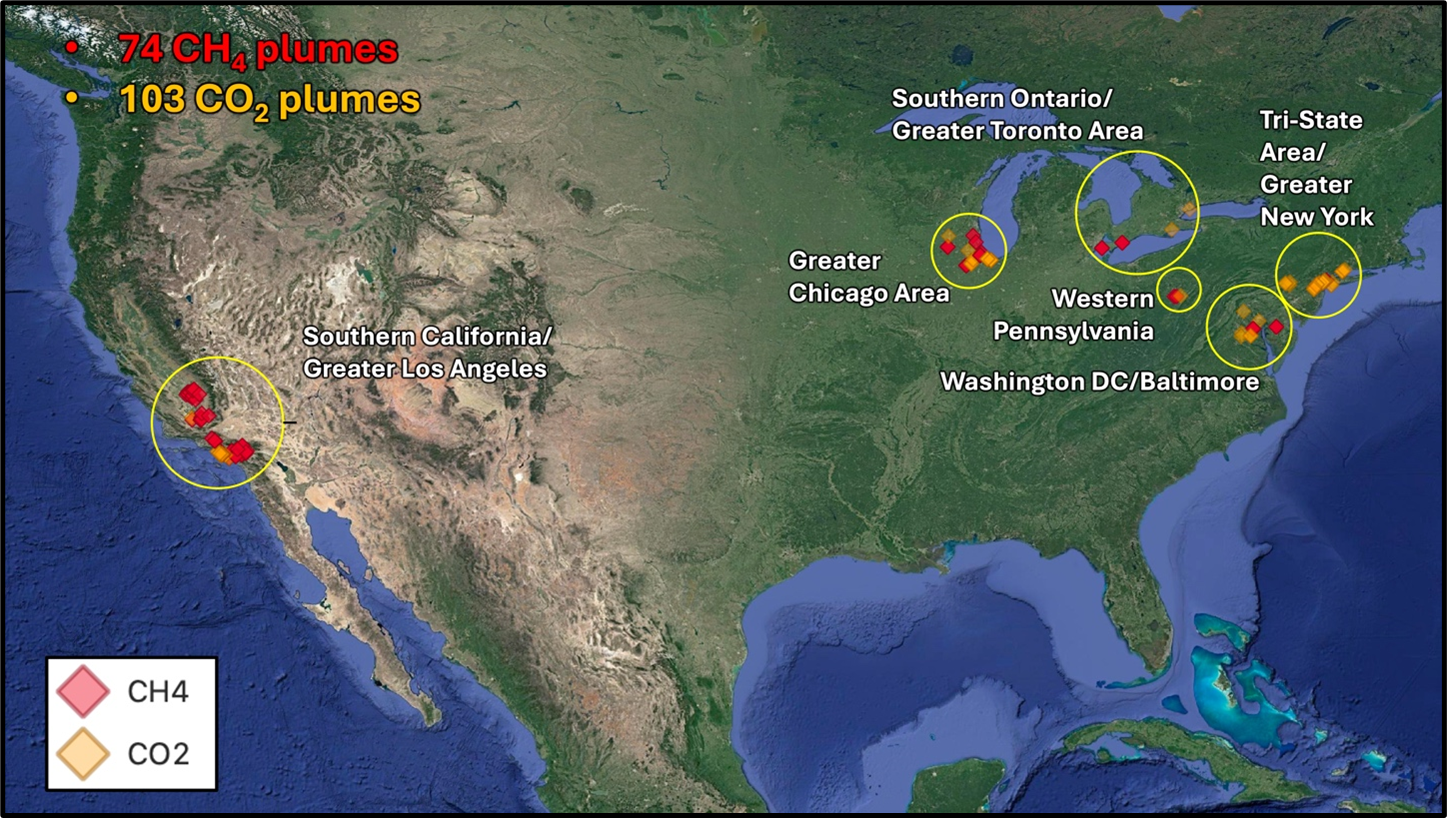
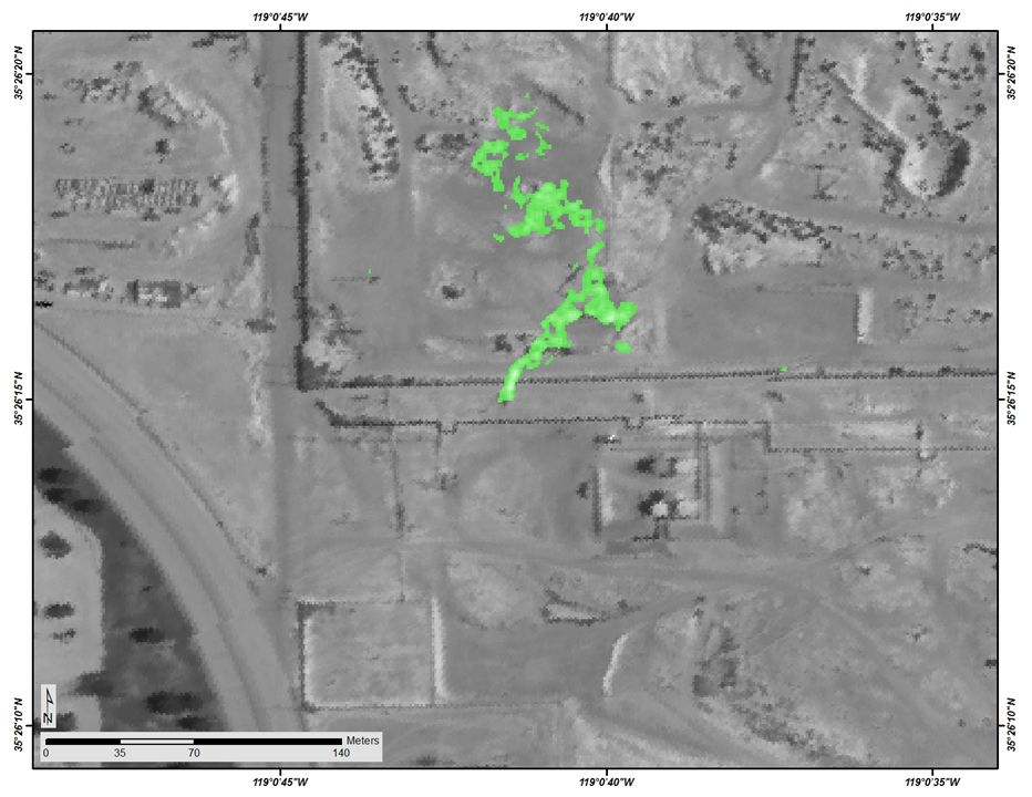
STAQS AVIRIS-NG-derived Methane and Carbon Dioxide Plumes, 2023
National Aeronautics and Space Administration —
This dataset contains enhanced column-integrated methane (CH4) and carbon dioxide (CO2) (concentration lengths) acquired from 211 flight lines across North America... -
Federal
SAFARI 2000 MISR Level 2 Data, Southern Africa, Dry Season 2000
National Aeronautics and Space Administration —
MISR (Multi-angle Imaging SpectroRadiometer) views the sunlit Earth simultaneously at nine widely spaced and collects global images with high spatial detail in four... -
Federal
Vulcan: High-Resolution Annual Fossil Fuel CO2 Emissions in USA, 2010-2015, Version 3
National Aeronautics and Space Administration —
The Vulcan version 3.0 annual dataset provides estimates of annual carbon dioxide (CO2) emissions from the combustion of fossil fuels (FF) and CO2 emissions from... -
Federal
COMEX: AMOG Surface Mobile in situ Data Surveyor, USA, 2014-2015
National Aeronautics and Space Administration —
This dataset provides AutoMObile trace Gas Surveyor (AMOG) in situ relevant datasets collected during the CO2 and Methane EXperiment (COMEX) field campaign and... -
Federal
NACP MCI: CO2 Emissions Inventory, Upper Midwest Region, USA., 2007
National Aeronautics and Space Administration —
This data set provides a bottom-up CO2 emissions inventory for the mid-continent region of the United States for the year 2007. The study was undertaken as part of... -
Federal
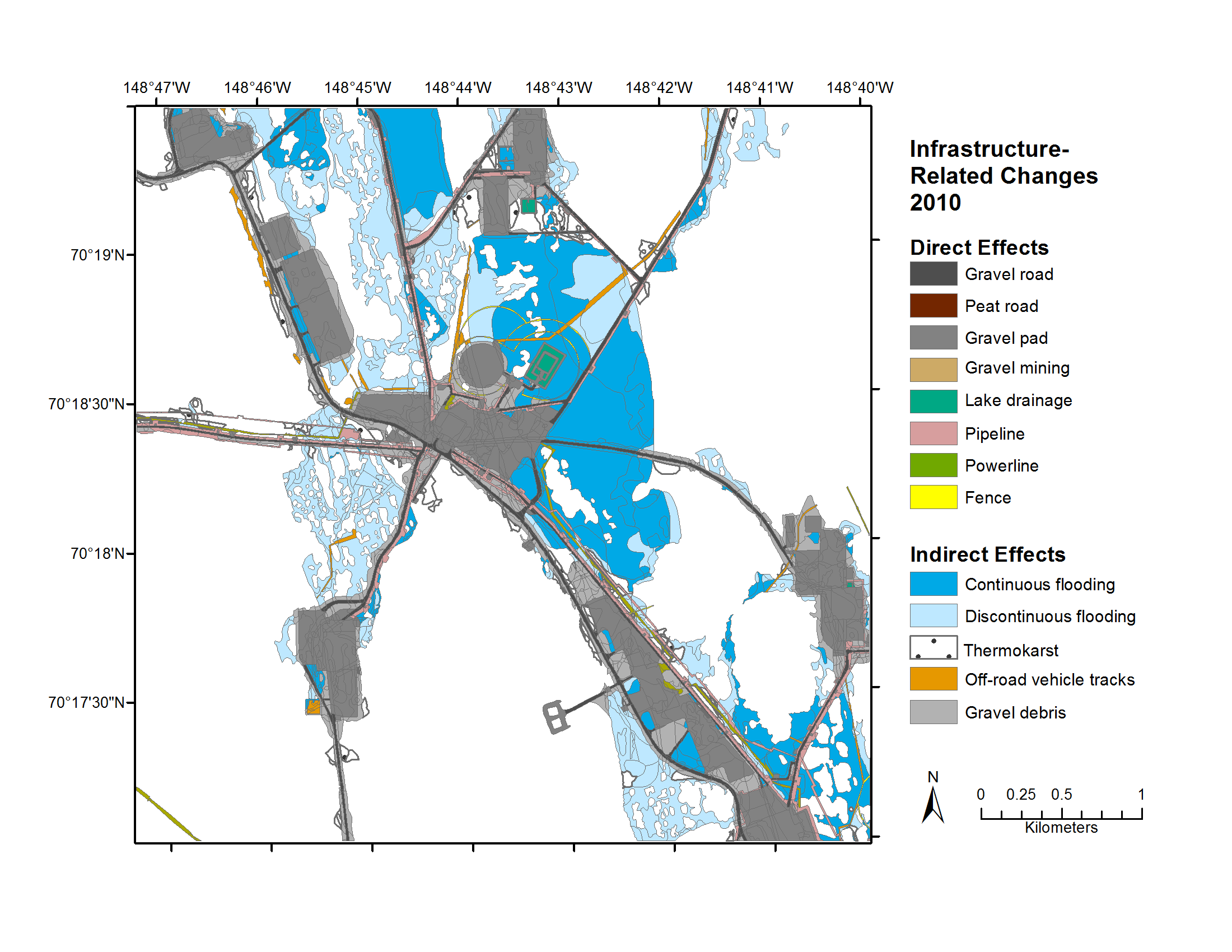
Geobotanical and Impact Map Collection for Prudhoe Bay Oilfield, Alaska, 1972-2010
National Aeronautics and Space Administration —
This data set provides a collection of maps of geoecological characteristics of areas within the Beechey Point quadrangle near Prudhoe Bay on the North slope of... -
Federal
SAFARI 2000 C-130 Aerosol and Meteorological Data, Dry Season 2000
National Aeronautics and Space Administration —
The Met Office C-130 research aircraft was based at Windhoek, Namibia between September 5-16, 2000, where it conducted a series of flights over Namibia as part of the... -
Federal
LBA-ECO ND-02 Agricultural and Secondary Forest Soil Trace Gas Flux, Para: 2001-2004
National Aeronautics and Space Administration —
Fires set for slash-and-burn agriculture contribute to the current unsustainable accumulation of atmospheric greenhouse gases, and they also deplete the soil of... -
Federal
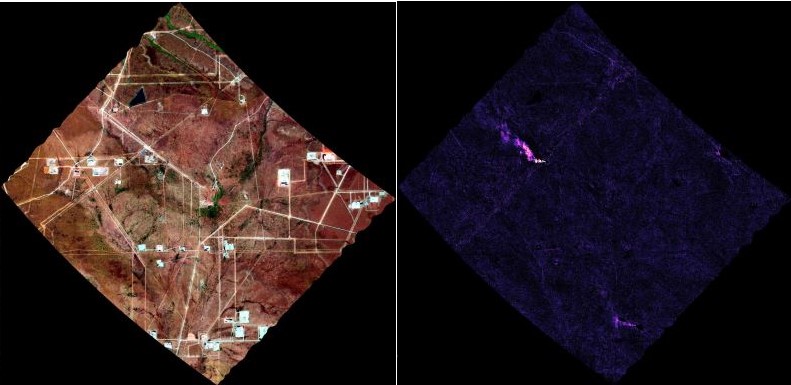
AVIRIS-3 L2B Greenhouse Gas Enhancements, Facility Instrument Collection
National Aeronautics and Space Administration —
This dataset contains Level 2B (L2b) enhancements of greenhouse gasses (GHG) derived from imagery collected by the Airborne Visible / Infrared Imaging Spectrometer-3... -
Federal
ATom: Merged Atmospheric Chemistry, Trace Gases, and Aerosols
National Aeronautics and Space Administration —
This dataset provides information on greenhouse gases and human-produced air pollution, including atmospheric concentrations of carbon dioxide (CO2), methane (CH4),... -
Federal
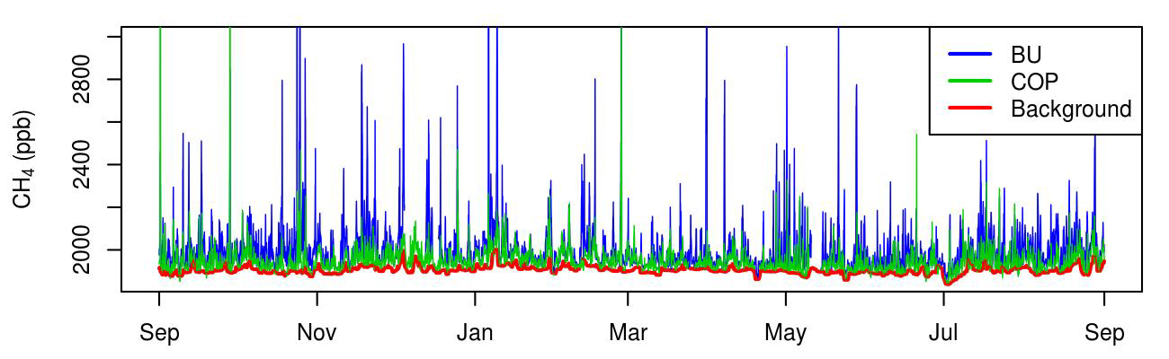
CMS: Atmospheric Methane Concentrations and Prior Emissions, Boston, MA, 2012-2014
National Aeronautics and Space Administration —
This data set provides average hourly measured, modeled enhancements, and background methane (CH4) concentrations, atmospheric ethane (C2H6) measurements, prior CH4... -
Federal
Longwave-infrared spectral imagery in support of COMEX, 2014
National Aeronautics and Space Administration —
This dataset provides calibrated at-sensor radiance, retrieved surface brightness temperature, and adaptive coherence estimator (ACE) detection imagery of methane,...

Official websites use .gov
A
.gov website belongs to an official government
organization in the United States.
Secure .gov websites use HTTPS
A
lock (
) or https:// means you’ve safely connected to
the .gov website. Share sensitive information only on official,
secure websites.