

62 datasets found for "Harvesting"
-
Federal
LUH1: Harmonized Global Land Use for Years 1500-2100, V1
National Aeronautics and Space Administration —
These data represent fractional land use and land cover patterns annually for the years 1500 - 2100 for the globe at 0.5-degree (~50-km) spatial resolution. Land use... -
Federal
LBA-ECO ND-11 Pre-harvest Forest Tree and Liana Biomass, NW Mato Grosso, Brazil: 2003
National Aeronautics and Space Administration —
The purpose of this study was to determine if spatially-explicit commercial timber inventories (CTI) could be used in conjunction with satellite imagery to improve... -
Federal
LUH2-ISIMIP2b Harmonized Global Land Use for the Years 2015-2100
National Aeronautics and Space Administration —
This dataset provides 0.25-degree gridded, global, annual estimates of fractional land use and land cover patterns for the period 2015-2100, designed to support the... -
Federal
BigFoot Leaf Area Index Surfaces for North and South American Sites, 2000-2003
National Aeronautics and Space Administration —
The BigFoot project gathered leaf area index (LAI) data for nine EOS Land Validation Sites located from Alaska to Brazil from 2000 to 2003. Each site is... -
Federal
Forest Carbon Stocks and Fluxes from the NFCMS, Conterminous USA, 1990-2010
National Aeronautics and Space Administration —
This dataset, derived from the National Forest Carbon Monitoring System (NFCMS), provides estimates of forest carbon stocks and fluxes in the form of aboveground... -
Federal
LBA-ECO LC-13 GIS Coverages of Logged Areas, Tapajos Forest, Para, Brazil: 1996, 1998
National Aeronautics and Space Administration —
We combined a detailed field study of canopy gap fraction with spectral mixture analysis of Landsat ETM+ satellite imagery to assess landscape and regional dynamics... -
Federal
LBA-ECO CD-04 Leaf Litter Data, km 83 Tower Site, Tapajos National Forest, Brazil
National Aeronautics and Space Administration —
Above-ground litter productivity was measured in a 18 ha plot adjacent to the eddy flux tower at the logged forest tower site, km 83, Tapajos National Forest, Para,... -
Federal
LBA-ECO LC-13 GIS Coverages of Logged Areas, Cauaxi, Para, Brazil: 1996, 1998
National Aeronautics and Space Administration —
We combined a detailed field study of canopy gap fraction with spectral mixture analysis of Landsat ETM+ satellite imagery to assess landscape and regional dynamics... -
Federal
NACP: Forest Carbon Stocks, Fluxes and Productivity Estimates, Western USA, 1979-2099
National Aeronautics and Space Administration —
This dataset contains annual estimates of carbon stocks, fluxes, and productivity over forested land in 11 states of the western USA (Arizona, California, Colorado,... -
Federal
Understory Vegetation Biomass from Selected Burned and Unburned sites in Alaska
National Aeronautics and Space Administration —
This dataset provides measurements of vegetation biomass from 11 locations across Alaska during 2016 to 2018. Vegetation was harvested from plots that were located at... -
Federal
NPP Cropland: Gridded Estimates For the Central USA, 1982-1996, R1
National Aeronautics and Space Administration —
This data set contains a single data file (.csv format) that provides gridded values of net primary productivity (NPP) for cropland in eight counties in the central... -
Federal
CMS: Carbon Fluxes from Global Agricultural Production and Consumption, 2005-2011
National Aeronautics and Space Administration —
This data set provides global estimates of carbon fluxes associate with annual crop net primary production (NPP) and harvested biomass, annual uptake and release by... -
Federal
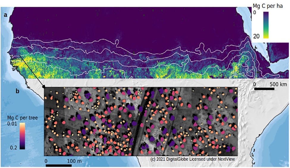
Carbon Stocks of Individual Trees in African Drylands: Allometry and Output Data
National Aeronautics and Space Administration —
This dataset provides allometrically-estimated carbon stocks of 9,947,310,221 tree crowns derived from 50-cm resolution satellite images within the 0 to 1000 mm/year... -
Federal
NACP North American 8-km Net Ecosystem Exchange and Component Fluxes, 2004
National Aeronautics and Space Administration —
This data set provides modeled carbon flux estimates at 8-km spatial resolution over North America for the year 2004 of (1) net ecosystem exchange (NEE) of carbon...
62 datasets found for "Harvesting"