

6 datasets found for "Glaciers"
-
Federal
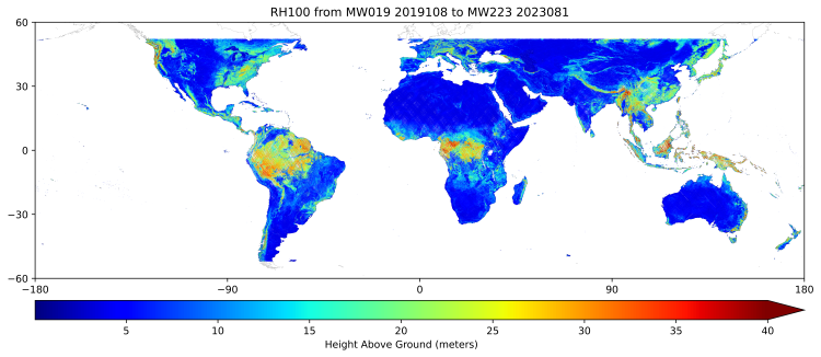
GEDI L3 Gridded Land Surface Metrics, Version 1
National Aeronautics and Space Administration —
This dataset provides Global Ecosystem Dynamics Investigation (GEDI) Level 3 (L3) gridded mean canopy height, standard deviation of canopy height, mean ground... -
Federal
Northern and Mid-Latitude Soil Database, Version 1, R1
National Aeronautics and Space Administration —
The U.S. Department of Agriculture, Agriculture and Agri-Food Canada, the Russian Academy of Agricultural Sciences, the University of Copenhagen Institute of... -
Federal
LBA Regional Hydrographic Data, 1-Degree, Release 2.2 (Cogley)
National Aeronautics and Space Administration —
This subset of the Global Hydrographic data set (GGHYDRO) Release 2.2 for the study area of the Large Scale Biosphere-Atmosphere Experiment in Amazonia (LBA) in South... -
Federal
GEDI L3 Gridded Land Surface Metrics, Version 2
National Aeronautics and Space Administration —
This dataset provides Global Ecosystem Dynamics Investigation (GEDI) Level 3 (L3) gridded mean canopy height, standard deviation of canopy height, mean ground... -
Federal
SAFARI 2000 Hydrographic Data, 1-Deg, Release 2.2 (Cogley)
National Aeronautics and Space Administration —
This southern African subset of the Global Hydrographic data set (GGHYDRO) Release 2.2 is organized into 19 files containing terrain type, stream frequency counts,... -
Federal
ABoVE: Dall Sheep Response to Snow and Landscape Covariates, Alaska, 2005-2008
National Aeronautics and Space Administration —
This dataset provides daily estimates of snow depth and snow density for the study area in Lake Clark National Park and Preserve (LCNPP), Alaska. The data were...
6 datasets found for "Glaciers"