
-
Federal
Global Forest Ecosystem Structure and Function Data For Carbon Balance Research
National Aeronautics and Space Administration —
A comprehensive global database has been assembled to quantify CO2 fluxes and pathways across different levels of integration (from photosynthesis up to net ecosystem... -
Federal
NACP Site: Terrestrial Biosphere Model and Aggregated Flux Data in Standard Format
National Aeronautics and Space Administration —
This data set provides standardized output variables for gross primary productivity (GPP), net ecosystem exchange (NEE), leaf area index (LAI), ecosystem respiration... -
Federal
LBA-ECO ND-11 Forest Soil Structure and Nitrate, NW Mato Grosso, Brazil: 2004-2005
National Aeronautics and Space Administration —
This data set reports the results of the analysis of soil samples for Nitrate (NO3) and physical properties that were collected for one year following reduced impact... -
Federal
LBA Regional Global Historical Climatology Network, V. 1, 1832-1990
National Aeronautics and Space Administration —
This data set consists of a subset of the Global Historical Climatology Network (GHCN) Version 1 database for the study area of the Large Scale Biosphere-Atmosphere... -
Federal
NACP Site: Terrestrial Biosphere Model Output Data in Original Format
National Aeronautics and Space Administration —
This data set contains the original model output data submissions from the 24 terrestrial biosphere models (TBM) that participated in the North American Carbon... -
Federal
Wind Profile Data: LIDAR - NOAA (FIFE)
National Aeronautics and Space Administration —
The aim of this wind profile study was to derive wind profiles and momentum fluxes from the National Oceanic and Atmospheric Administration (NOAA)/Wave Propagation... -
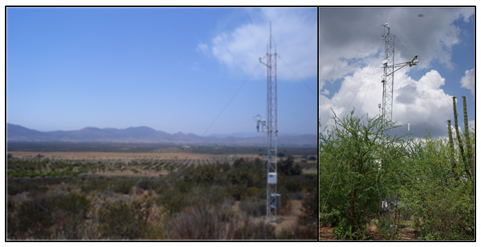
Federal
CMS: Evapotranspiration and Meteorology, Water-Limited Shrublands, Mexico, 2008-2010
National Aeronautics and Space Administration —
This data set provides daily average observations for evapotranspiration (measured and gap-filled), precipitation, net radiation, soil water content, air temperature,... -
Federal
LBA-ECO CD-04 Dendrometry, km 83 Tower Site, Tapajos National Forest, Brazil
National Aeronautics and Space Administration —
A dendrometry study was conducted at the logged forest tower site, km 83 site, Tapajos National Forest, Para, Brazil over a period of 4 years following the... -
Federal
LBA-ECO CD-32 LBA Model Intercomparison Project (LBA-MIP) Forcing Data
National Aeronautics and Space Administration —
The source meteorological observations for the forcing data, from the nine Brazilian flux towers, were recently published as Saleska, et al. (2013). See related data... -
Federal
BOREAS Level-3S SPOT Imagery: Scaled At-Sensor Radiance in LGSOWG Format
National Aeronautics and Space Administration —
For BOREAS, the level-3s SPOT data, along with the other remotely sensed images, were collected in order to provide spatially extensive information over the primary... -
Federal
High Resolution Global Contiguous SIF Estimates from OCO-2 SIF and MODIS, Version 2
National Aeronautics and Space Administration —
This dataset provides spatially-contiguous global mean daily solar-induced chlorophyll fluorescence (SIF) estimates at 0.05 degree (approximately 5 km at the equator)... -
Federal
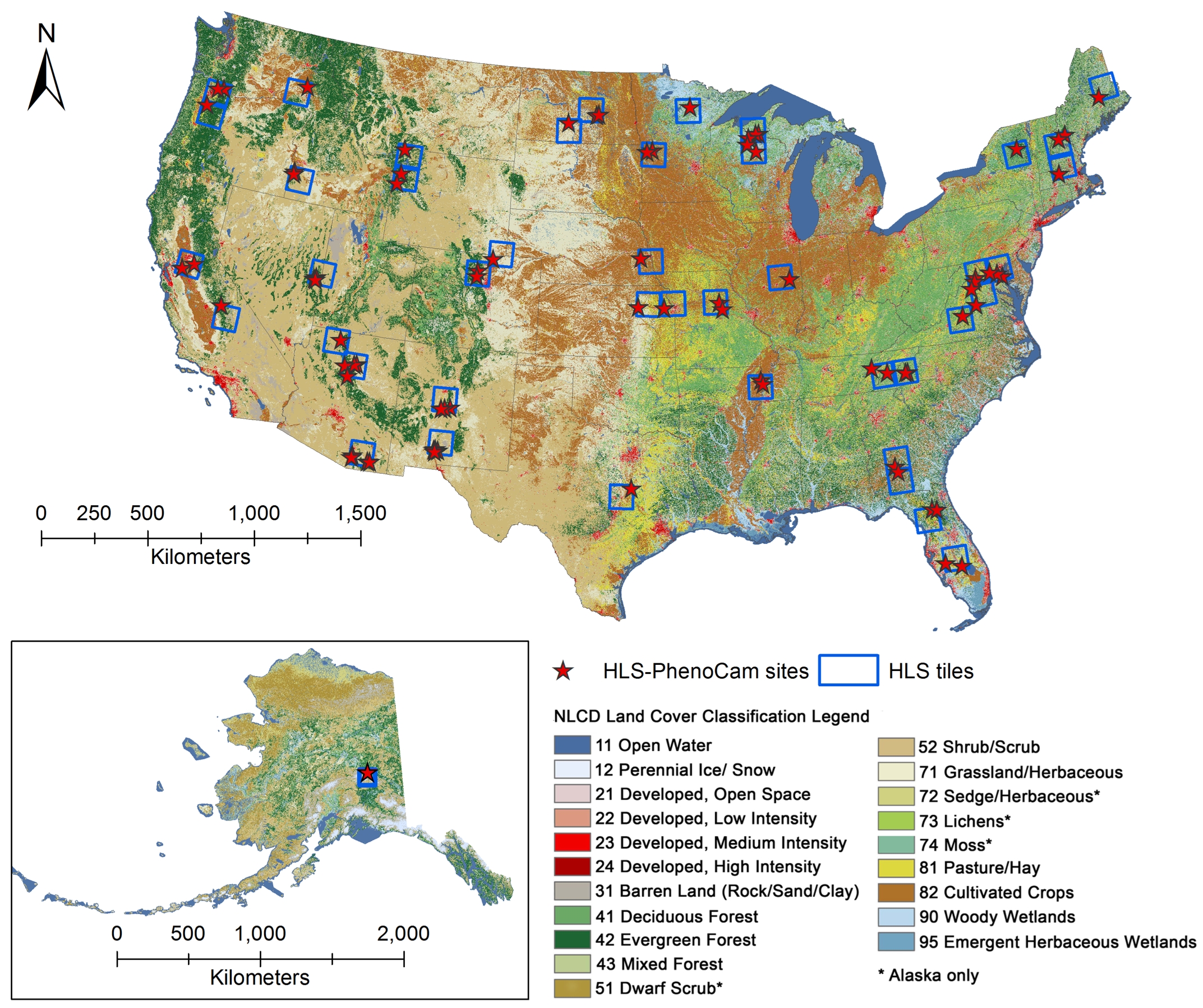
Phenology derived from Satellite Data and PhenoCam across CONUS and Alaska, 2019-2020
National Aeronautics and Space Administration —
This dataset provides a reference of land surface phenology (LSP) at 30-m pixels for 78 regions of 10 x 10 km2 across a wide range of ecological and climatic regions... -
Federal
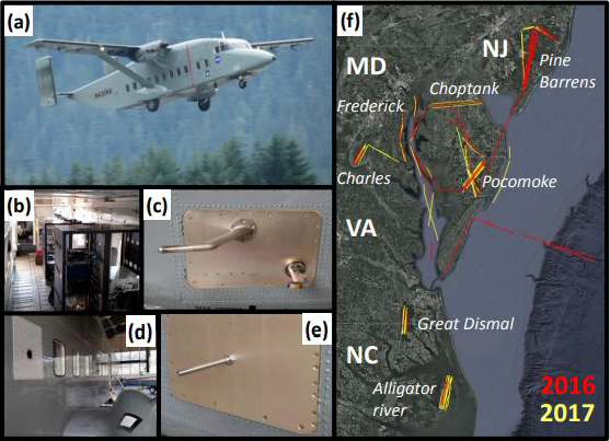
CARAFE: Regional Airborne Greenhouse Gases Eddy Covariance Measurements, 2016-2017
National Aeronautics and Space Administration —
This dataset provides airborne eddy covariance (EC) fluxes of carbon dioxide, methane, sensible heat, and latent heat at high spatial resolution collected during the... -
Federal
SAFARI 2000 Leaf Area Index and Canopy Structure, Kalahari Transect, 1999-2000
National Aeronautics and Space Administration —
Data from the Tracing Radiation and Architecture of Canopies (TRAC) instrument were collected at five sites along the International Geosphere-Biosphere Programme... -
Federal
NPP Tropical Forest: Marafunga, Papua New Guinea, 1970-1971, R1
National Aeronautics and Space Administration —
This data set contains two ASCII files (.txt format), one providing net primary production (NPP) component data for a lower montane rainforest and the other providing... -
Federal
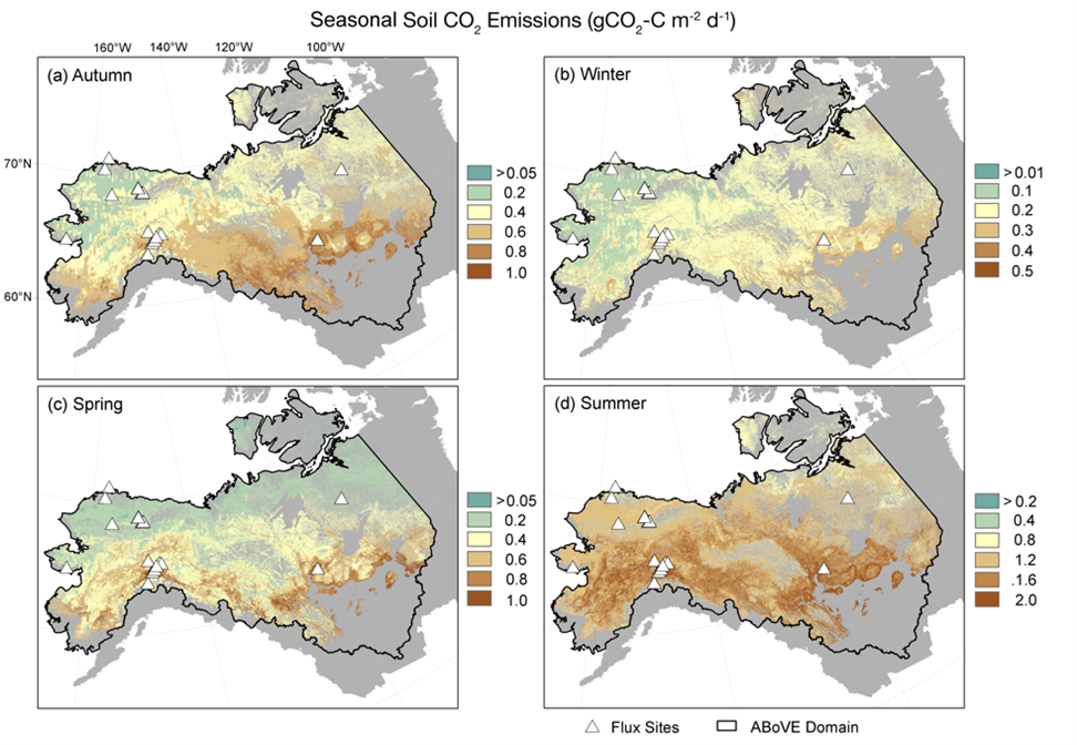
Soil Respiration Maps for the ABoVE Domain, 2016-2017
National Aeronautics and Space Administration —
This dataset provides gridded estimates of carbon dioxide (CO2) emissions from soil respiration occurring within permafrost-affected tundra and boreal ecosystems of... -
Federal
Global Historical Climatology Network, 1753-1990
National Aeronautics and Space Administration —
This data set contains monthly temperature, precipitation, sea-level pressure, and station-pressure data for thousands of meteorological stations worldwide. The... -
Federal
COMEX: AMOG Surface Mobile in situ Data Surveyor, USA, 2014-2015
National Aeronautics and Space Administration —
This dataset provides AutoMObile trace Gas Surveyor (AMOG) in situ relevant datasets collected during the CO2 and Methane EXperiment (COMEX) field campaign and...

Official websites use .gov
A
.gov website belongs to an official government
organization in the United States.
Secure .gov websites use HTTPS
A
lock (
) or https:// means you’ve safely connected to
the .gov website. Share sensitive information only on official,
secure websites.