
-
Federal
Global Fire Atlas with Characteristics of Individual Fires, 2003-2016
National Aeronautics and Space Administration —
The Global Fire Atlas is a global dataset that tracks the day-to-day dynamics of individual fires to determine the timing and location of ignitions, fire size,... -
Federal
LBA-ECO LC-08 Passive Ground-based Fire Data, Para and Mato Grosso Brazil: 2001-2002
National Aeronautics and Space Administration —
This data set reports observations of fires in the vicinity of Maraba, Para, Brazil, from November 3-5th, 2001, and in Mato Grosso, Brazil, between Cuiaba and Alta... -
Federal
LBA-ECO LC-02 GOES-08 Hot Pixel Data from Acre, Brazil: 1998, 2000, and 2001
National Aeronautics and Space Administration —
This data set provides hot pixel data, as an indicator of fires that were detected by the GOES-8 satellite for the state of Acre, Brazil. Image data were collected... -
Federal
CARVE: Alaskan Fire Emissions Database (AKFED), 2001-2013
National Aeronautics and Space Administration —
This data set provides estimates of annual carbon emissions (kg carbon per square meter) from boreal fires at 450-m resolution for the state of Alaska between 2001... -
Federal
LBA-ECO CD-05 Understory Fuel Stick Moisture, km 67 Site, Para, Brazil: 1998-2000
National Aeronautics and Space Administration —
This data set contains moisture content measurements for fuel sticks located in the forest understory of the rainfall exclusion experimental site, Tapajos National... -
Federal
NACP: Forest Carbon Stocks, Fluxes and Productivity Estimates, Western USA, 1979-2099
National Aeronautics and Space Administration —
This dataset contains annual estimates of carbon stocks, fluxes, and productivity over forested land in 11 states of the western USA (Arizona, California, Colorado,... -
Federal
SAFARI 2000 Global Burned Area Map, 1-km, Southern Africa, 2000
National Aeronautics and Space Administration —
The Global Burned Area 2000 initiative (GBA2000) was launched by the Global Vegetation Mapping Unit of the Joint Research Centre of the European Commission, in... -
Federal
LBA-ECO LC-23 ASTER and MODIS Fire Data Comparison for Brazil: 2003-2004
National Aeronautics and Space Administration —
This data set contains data associated with MODIS fire maps generated using two different algorithms and compared against fire maps produced by ASTER. These data... -
Federal
Annual Burned Area from Landsat, Mawas, Central Kalimantan, Indonesia, 1997-2015
National Aeronautics and Space Administration —
This dataset provides maps of annual burned area for the part of Mawas conservation program in Central Kalimantan, Indonesia from 1997 through 2015. Landsat imagery... -
Federal
ABoVE: Burn Severity of Soil Organic Matter, Northwest Territories, Canada, 2014-2015
National Aeronautics and Space Administration —
This dataset provides maps at 30-m resolution of landscape surface burn severity (surface litter and soil organic layers) from the 2014-2015 fires in the Northwest... -
Federal
NAFD-ATT Forest Canopy Cover Loss from Landsat, CONUS, 1986-2010
National Aeronautics and Space Administration —
Characterizing the cause of forest canopy changes through time is fundamental to understanding current and future forest functions. A better understanding of forest... -
Federal
Distribution of Estimated Stand Age Across Siberian Larch Forests, 1989-2012
National Aeronautics and Space Administration —
This data set provides mapped estimates of the stand age of young (less than 25 years old) larch forests across Siberia from 1989-2012 at 30-m resolution. The age... -
Federal
Annual wildland fire emissions (WFEIS v0.5) for Conterminous US and Alaska, 2001-2013
National Aeronautics and Space Administration —
This data set contains annual modeled estimates of wildland fire emissions at 0.01 degree (~1-km) spatial resolution from the Wildland Fire Emissions Information... -
Federal
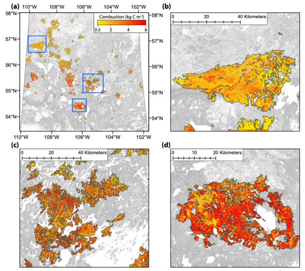
ABoVE: Spatial Estimates of Carbon Combustion from Wildfires across SK, Canada, 2015
National Aeronautics and Space Administration —
This dataset provides spatial estimates of carbon combustion from all 2015 wildfire burned areas across Saskatchewan, Canada, on a 30-m grid. Carbon combustion (kg... -
Federal
SAFARI 2000 Emissions Estimates, MODIS Burned Area Product, Dry Season 2000
National Aeronautics and Space Administration —
The recently generated MODIS burned area product over southern Africa for the month of September 2000 was used to calculate regional biomass burning emissions from... -
Federal
ABoVE: Landsat-derived Burn Scar dNBR across Alaska and Canada, 1985-2015
National Aeronautics and Space Administration —
This dataset contains differenced Normalized Burned Ratio (dNBR) at 30-m resolution calculated for burn scars from fires that occurred within the Arctic Boreal and... -
Federal
Tree Mortality from Fires and Bark Beetles at 1-km Resolution, Western USA, 2003-2012
National Aeronautics and Space Administration —
This dataset provides annual estimates of tree mortality due to fires and bark beetles from 2003 to 2012 on forestland in the continental western United States. Tree... -
Federal
SAFARI 2000 Historical Fire Maps, Kruger National Park, 1992-2001
National Aeronautics and Space Administration —
Kruger National Park (KNP) was established in 1898 to protect wildlife on nearly 2 million hectares of the South African Lowveld. The climate in this region of South... -
Federal
LBA-ECO LC-02 Forest Flammability Data, Catuaba Experimental Farm, Acre, Brazil: 1998
National Aeronautics and Space Administration —
This data set provides the results of controlled burns conducted to assess the flammability of mature forests on the Catuaba Experimental Farm of the Federal... -
Federal
LBA-ECO LC-23 Characterization of Vegetation Fire Dynamics for Brazil: 2001-2003
National Aeronautics and Space Administration —
Satellite fire detection was determined from two sensors—the Advanced Very High Resolution Radiometer (AVHRR) on NOAA-12 and the Moderate Resolution Imaging...

Official websites use .gov
A
.gov website belongs to an official government
organization in the United States.
Secure .gov websites use HTTPS
A
lock (
) or https:// means you’ve safely connected to
the .gov website. Share sensitive information only on official,
secure websites.