
-
Federal
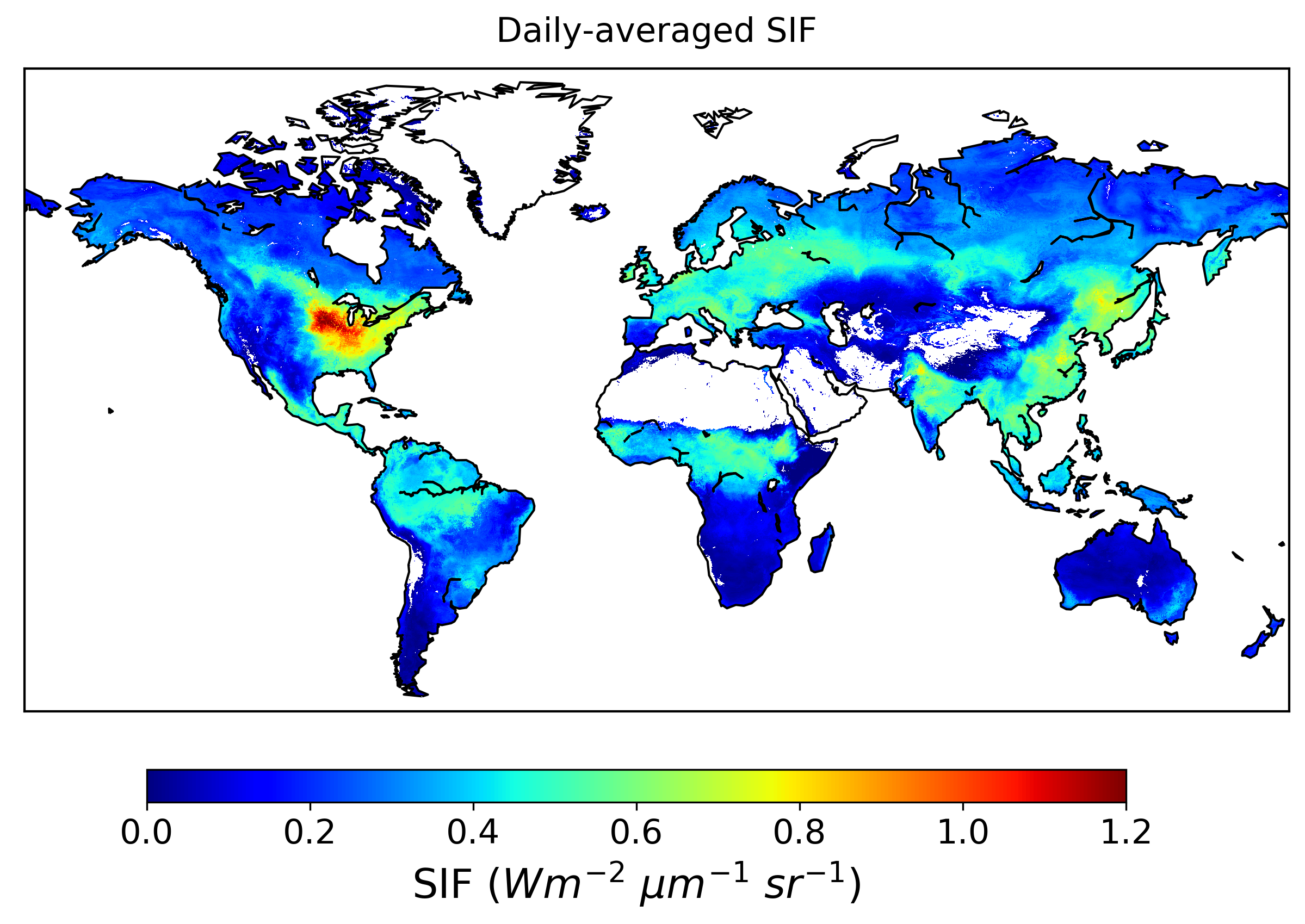
Global High-Resolution Estimates of SIF from Fused SCIAMACHY and GOME-2, V2
National Aeronautics and Space Administration —
This dataset provides global solar-induced chlorophyll fluorescence (SIF) estimates at a 0.05-degree resolution (approximately 5 km at the equator) for each month... -
Federal
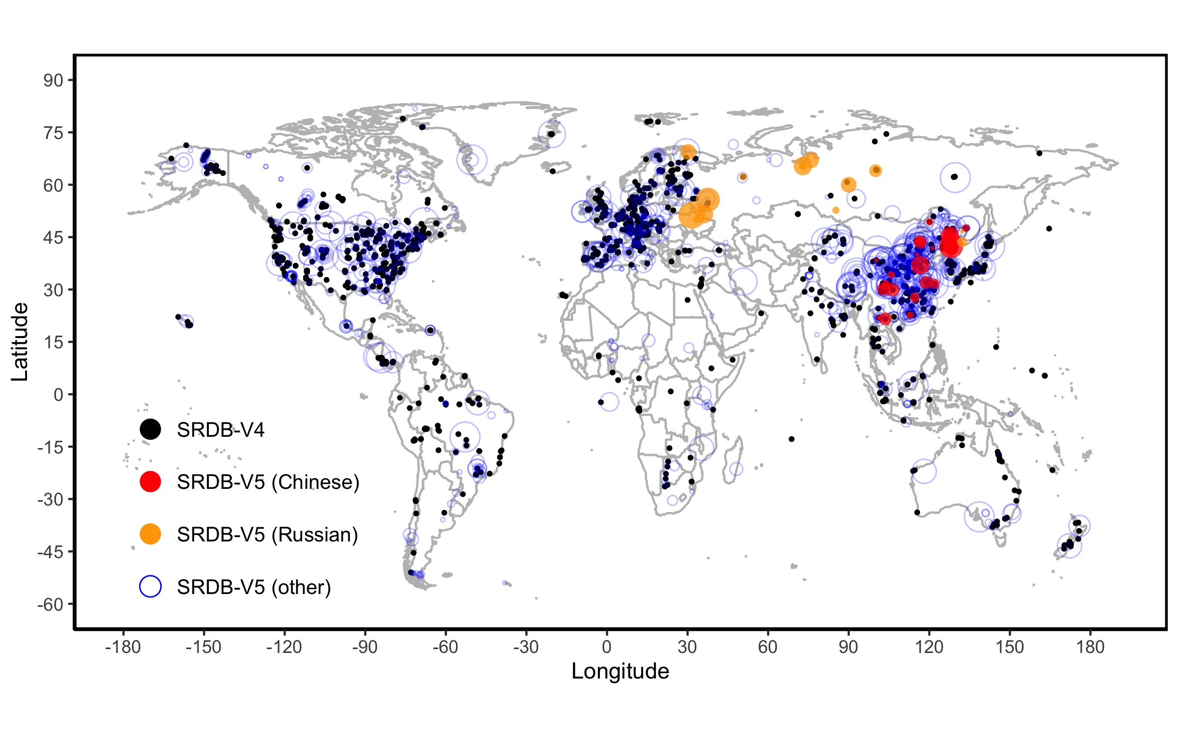
A Global Database of Soil Respiration Data, Version 5.0
National Aeronautics and Space Administration —
The Soil Respiration Database (SRDB) is a near-universal compendium of published soil respiration (Rs) data. The database encompasses published studies that report at... -
Federal
LiDAR Derived Forest Aboveground Biomass Maps, Northwestern USA, 2002-2016
National Aeronautics and Space Administration —
This dataset provides maps of aboveground forest biomass (AGB) of living trees and standing dead trees in Mg/ha across portions of Northwestern United States,... -
Federal
SAFARI 2000 MODIS 500-m Burned Area Products, Southern Africa, Dry Season 2000
National Aeronautics and Space Administration —
The SAFARI 2000 project was selected as the first regional test for a prototype regional 500 m MODIS burned area product. The MODIS burned area product maps the 500 m... -
Federal
SAFARI 2000 Estimated BVOC Emissions for Southern African Land Cover Types
National Aeronautics and Space Administration —
Improved vegetation distribution and emission data for Africa south of the equator were developed for the Southern African Regional Science Initiative (SAFARI 2000)... -
Federal
Stream Flow Storm Data (FIFE)
National Aeronautics and Space Administration —
The Storm Event Stream Flow Data Set were collected during storm events from five treatment areas within the Konza Prairie Long-Term Ecological Research (LTER) site... -
Federal
Delta-X: Calibrated ANUGA Hydrodynamic Outputs for the Atchafalaya Basin, MRD, LA
National Aeronautics and Space Administration —
This dataset provides ANUGA hydrodynamic modeling results and input run-scripts for the Atchafalaya basin in the Mississippi River Delta in southern Louisiana, USA,... -
Federal
LBA-ECO LC-14 Modeled Soil and Plant Water Balance, Amazon Basin, 1995-2001
National Aeronautics and Space Administration —
A simple GIS soil-water balance model for the Amazon Basin, called RisQue (Risco de Queimadasa -- Fire Risk), was used to conduct an analysis of spatial and temporal... -
Federal
BigFoot Leaf Area Index Surfaces for North and South American Sites, 2000-2003
National Aeronautics and Space Administration —
The BigFoot project gathered leaf area index (LAI) data for nine EOS Land Validation Sites located from Alaska to Brazil from 2000 to 2003. Each site is... -
Federal
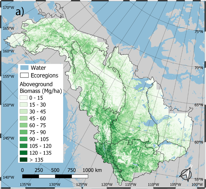
ABoVE: Annual Aboveground Biomass for Boreal Forests of ABoVE Core Domain, 1984-2014
National Aeronautics and Space Administration —
This dataset provides estimated annual aboveground biomass (AGB) density for live woody (tree and shrub) species and corresponding standard errors at a 30 m spatial... -
Federal
SAFARI 2000 TOMS Aerosol Index Data, Southern Africa, Dry Season 2000
National Aeronautics and Space Administration —
Daily Aerosol Index (AI) data from Earth Probe (EP) Total Ozone Mapping Spectrometer (TOMS) for the period of August 12-September 25, 2000 were processed and provided... -
Federal
High Resolution Global Contiguous SIF Estimates from OCO-2 SIF and MODIS, Version 2
National Aeronautics and Space Administration —
This dataset provides spatially-contiguous global mean daily solar-induced chlorophyll fluorescence (SIF) estimates at 0.05 degree (approximately 5 km at the equator)... -
Federal
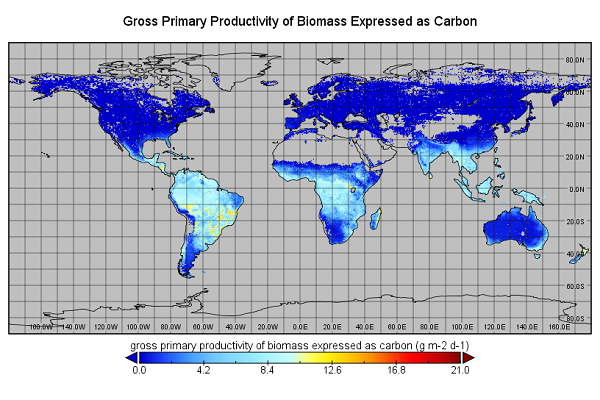
Global Monthly GPP from an Improved Light Use Efficiency Model, 1982-2016
National Aeronautics and Space Administration —
This dataset provides global monthly average gross primary productivity (GPP; g carbon/m2/d) modeled at 8 km spatial resolution for each of the 35 years from... -
Federal
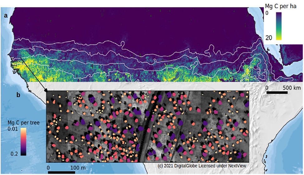
Carbon Stocks of Individual Trees in African Drylands: Allometry and Output Data
National Aeronautics and Space Administration —
This dataset provides allometrically-estimated carbon stocks of 9,947,310,221 tree crowns derived from 50-cm resolution satellite images within the 0 to 1000 mm/year... -
Federal
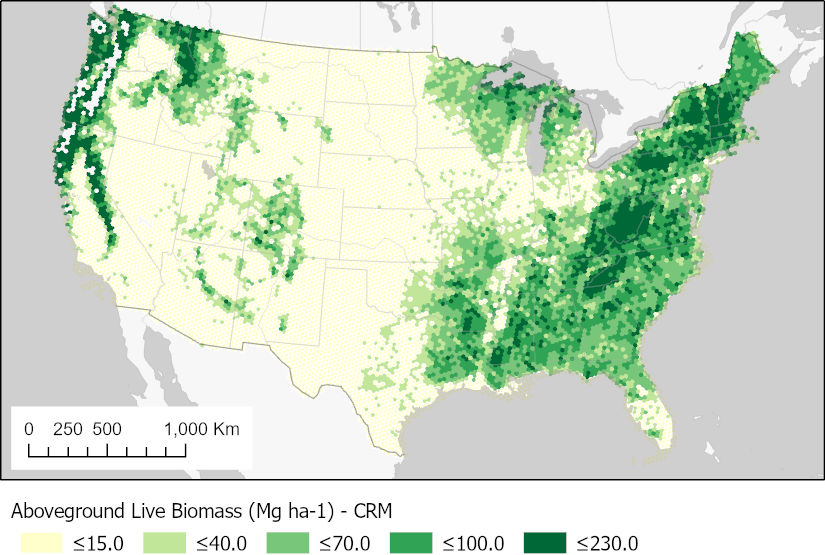
CMS: Forest Aboveground Biomass from FIA Plots across the Conterminous USA, 2009-2019
National Aeronautics and Space Administration —
This dataset provides forest biomass estimates for the conterminous United States based on data from the USDA Forest Inventory and Analysis (FIA) program. FIA... -
Federal
Soil Organic Carbon and Wetland Intrinsic Potential, Hoh River Watershed, WA, 2012-13
National Aeronautics and Space Administration —
This dataset contains estimates of soil organic carbon stocks and wetland intrinsic potential (WIP) across the Hoh River Watershed in the Olympic Peninsula, WA, USA... -
Federal
Anthropogenic Carbon Emission System, 2012-2017, Version 2
National Aeronautics and Space Administration —
This dataset provides estimates of hourly carbon dioxide (CO2) emissions from the combustion of fossil fuels at 1-km resolution for the coterminous United States... -
Federal
LBA-ECO ND-04 Secondary Forest Recovery, Structure, and LAI, Central Amazonia, Brazil
National Aeronautics and Space Administration —
This data set reports measurements of the canopy and structure of secondary forests regenerating from abandoned pastures. These secondary forests are located in the... -
Federal
SAFARI 2000 Upper Air Meteorological Profiles, Skukuza, Dry Seasons 1999-2000
National Aeronautics and Space Administration —
Vaisala RS80 sondes were deployed from Skukuza Airport, South Africa, to collect atmospheric sounding profiles of temperature and moisture data from the surface to 30...

Official websites use .gov
A
.gov website belongs to an official government
organization in the United States.
Secure .gov websites use HTTPS
A
lock (
) or https:// means you’ve safely connected to
the .gov website. Share sensitive information only on official,
secure websites.