
-
Federal
Delta-X: Soil Accretion Rates from Cs-137 Activity and NUMAR Validation, MRD, LA
National Aeronautics and Space Administration —
This dataset holds measurements of Cesium-137 (137Cs) activity sampled from sites in the Atchafalaya and Terrebonne Basins on the southern coast of Louisiana, USA.... -
Federal
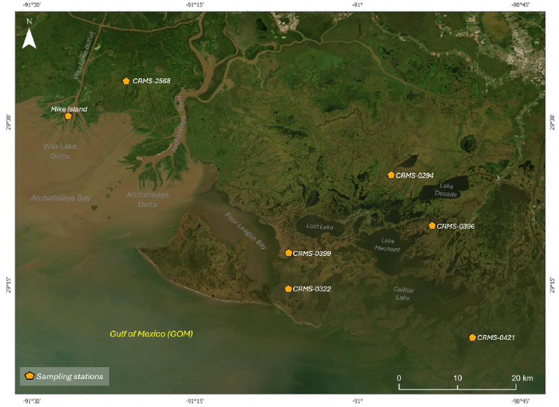
Delta-X: In Situ Water Surface Reflectance across MRD, LA, USA, 2021, V3
National Aeronautics and Space Administration —
This dataset includes above water measurements of remote-sensing reflectance measured in situ at field sampling stations during the Delta-X 2021 field efforts.... -
Federal
SAFARI 2000 CV-580 Aerosol and Cloud Data, Dry Season 2000 (CARG)
National Aeronautics and Space Administration —
The Cloud and Aerosol Research Group (CARG) of the University of Washington participated in the SAFARI-2000 Dry Season Aircraft campaign with their Convair-580... -
Federal
Sources of Methane Emissions (Vista-LA), South Coast Air Basin, California, USA
National Aeronautics and Space Administration —
This data set provides spatial data products with identified and classified locations of potential methane (CH4) emitting facilities and infrastructure in the South... -
Federal
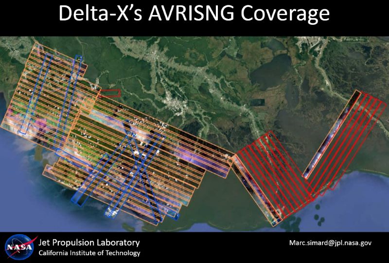
Delta-X: AVIRIS-NG L2 Surface Reflectance, MRD Louisiana, 2021
National Aeronautics and Space Administration —
This dataset provides Level 2 (L2) atmospherically corrected surface reflectance data acquired from NASA's Airborne Visible-Infrared Imaging Spectrometer-Next... -
Federal
Delta-X: Land Subsidence Rate, Mississippi River Delta (MRD), Louisiana, USA
National Aeronautics and Space Administration —
This dataset provides estimates of land subsidence rates for the Delta-X domain area within the Atchafalaya and Terrebonne basins for 2021. The study area is a... -
Federal
LBA-ECO TG-06 Vertical Profiles of Atmospheric Trace Gases over the Amazon Basin
National Aeronautics and Space Administration —
This data set contains measurements of atmospheric carbon dioxide (CO2), methane (CH4), carbon monoxide (CO), hydrogen (H2), nitrous oxide (N2O), and sulfur... -
Federal
Greenness Trends and Carbon Stocks of Mangrove Forests Across Mexico, 2001-2015
National Aeronautics and Space Administration —
This dataset provides estimates of greenness trends, above- and belowground carbon stocks, and climate variables of the persistent mangrove forests on the coasts of... -
Federal
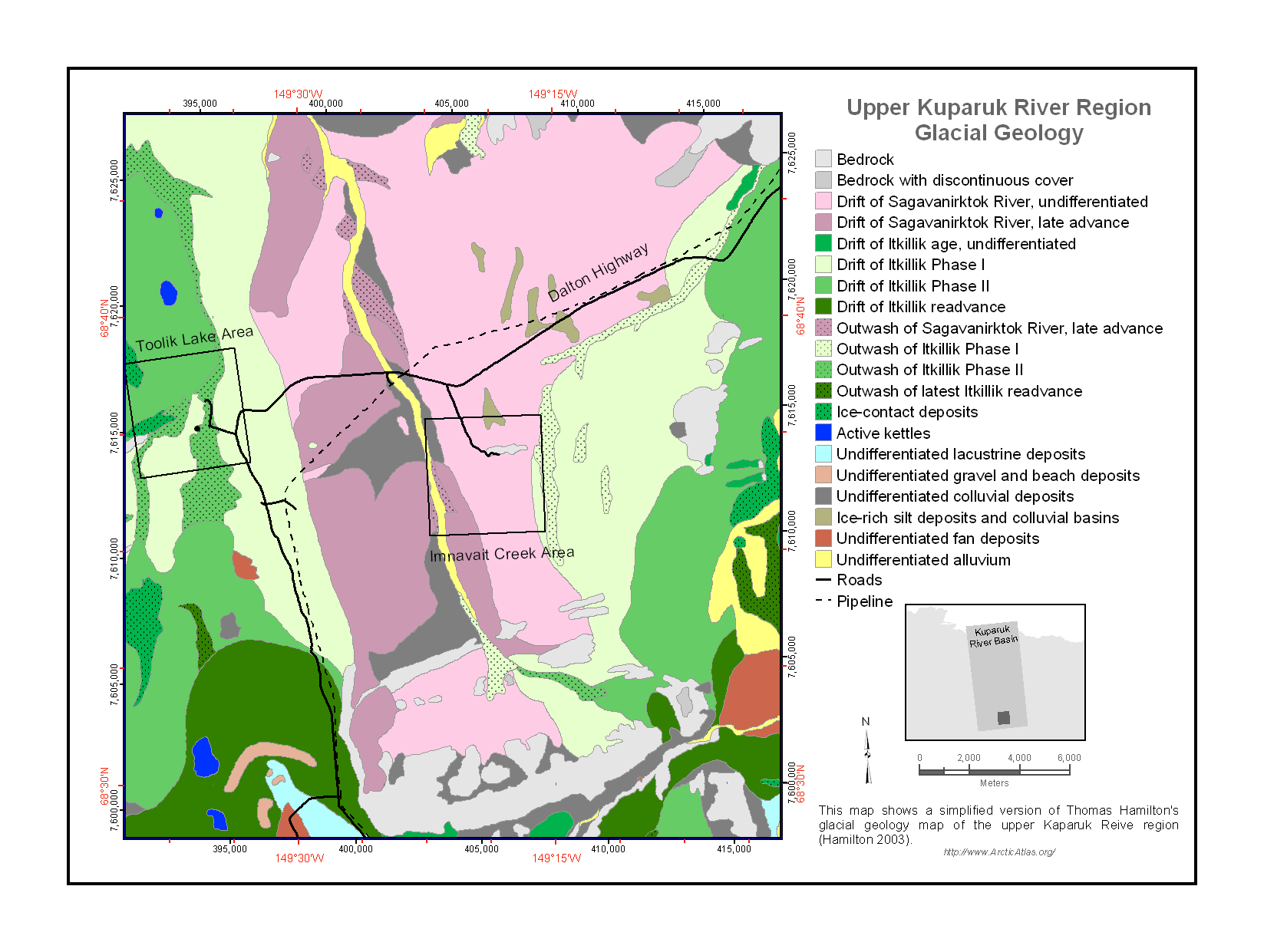
Maps of Vegetation Types and Physiographic Features, Kuparuk River Basin, Alaska
National Aeronautics and Space Administration —
This data set provides a collection of vegetation, landscape, geobotanical, elevation, hydrology, and geologic maps for the Kuparuk River Basin, North Slope, Alaska.... -
Federal
SAFARI 2000 Physical and Chemical Properties of Aerosols, Dry Season 2000
National Aeronautics and Space Administration —
The Southern African Regional Science Initiative 2000 (SAFARI 2000) provided an opportunity to study aerosol particles produced by savanna burning. We used analytical... -
Federal
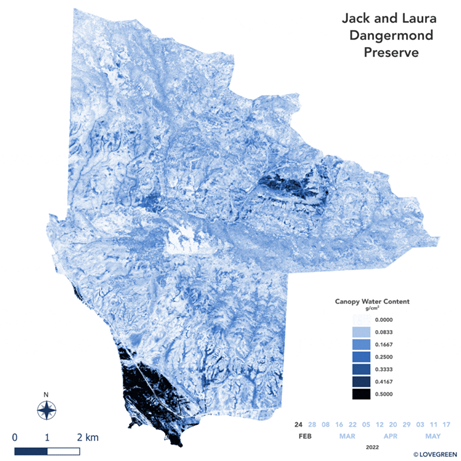
SHIFT: AVIRIS-NG Derived Gridded Mosaicked Canopy Water Content, California, 2022
National Aeronautics and Space Administration —
This dataset provides per-pixel vegetation canopy water content (CWC) derived from surface reflectance measured by the Airborne Visible/Infrared Imaging Spectrometer-... -
Federal
Delta-X: In situ Beam Attenuation and Particle Size from LISST-200X, 2021
National Aeronautics and Space Administration —
This dataset provides in situ measurements of beam attenuation coefficient at 670 nm, average suspended particle size, particle size distribution, and water... -
Federal
ABoVE: Reflectance Spectra of Tundra Plant Communities across Northern Alaska
National Aeronautics and Space Administration —
This dataset reports full-spectrum (350-2500 nm) reflectance measurements of diverse plant communities at the plot-level and individual plant species at the leaf-... -
Federal
Arctic Tundra Flux Study in the Kuparuk River Basin (Alaska), 1994-1996
National Aeronautics and Space Administration —
CO2 and water vapor fluxes and ecosystem characteristics were measured at 24 sites along a 317-km transect from the Arctic coast to the latitudinal treeline in Alaska... -
Federal
CARVE: Monthly Atmospheric CO2 Concentrations (2009-2013) and Modeled Fluxes, Alaska
National Aeronautics and Space Administration —
This data set reports monthly averages of atmospheric CO2 concentration from satellite and airborne observations between 2009 and 2013 and simulated present and... -
Federal
Blue Carbon-based Natural Climate Solutions, Priority Maps for the U.S., 2006-2011
National Aeronautics and Space Administration —
This dataset contains shapefiles showing location of tidal wetland parcels with the potential for net greenhouse gas removal if restored from current mapped condition...

Official websites use .gov
A
.gov website belongs to an official government
organization in the United States.
Secure .gov websites use HTTPS
A
lock (
) or https:// means you’ve safely connected to
the .gov website. Share sensitive information only on official,
secure websites.