
-
Federal
NACP Integrated Wildland and Cropland 30-m Fuel Characteristics Map, U.S.A., 2010
National Aeronautics and Space Administration —
The data set provides a 30-m comprehensive fuelbed characteristics map for both the wildland and cropland areas of the conterminous United States (CONUS) for 2010.... -
Federal
Global Vegetation Types, 1971-1982 (Matthews)
National Aeronautics and Space Administration —
The global vegetation type data of 1 x 1 degree latitude and longitude resolution were designed for use in studies of climate and climate change. Vegetation data were... -
Federal
SHIFT: Wetland Spectra, Salinity, and Fractional Cover, Devereux Slough, CA, 2022
National Aeronautics and Space Administration —
This dataset includes field data, analysis code, and corresponding airborne imagery collected and generated during the 2022 NASA Surface Biology Geology (SBG) High... -
Federal
Global Gridded Surfaces of Selected Soil Characteristics (IGBP-DIS)
National Aeronautics and Space Administration —
The Global Gridded Surfaces of Selected Soil Characteristics (IGBP-DIS) data set contains 7 data surfaces: soil-carbon density, total nitrogen density, field... -
Federal
SAFARI 2000 Wetlands Data Set, 1-Deg (Matthews and Fung)
National Aeronautics and Space Administration —
This database, compiled by Matthews and Fung (1987), provides information on the distribution and environmental characteristics of natural wetlands. The database was... -
Federal
LBA-ECO LC-08 Soil, Vegetation, and Land Cover Maps for Brazil and South America
National Aeronautics and Space Administration —
This data set provides (1) soil maps for Brazil that are digital versions of the MAPA DE SOLOS DO BRASIL (EMBRAPA, 1981) classified at three levels of detail,... -
Federal
NPP Multi-Biome: Gridded Estimates for Selected Regions Worldwide, 1954-1998, R3
National Aeronautics and Space Administration —
This data set provides two data files (.csv format) containing gridded (0.5-degree) estimates of net primary productivity (NPP), elevation, temperature,... -
Federal
LBA-ECO ND-01 Watershed Deforestation from Landsat TM Series, Rondonia, Brazil: 1999
National Aeronautics and Space Administration —
This data set provides estimates of watershed deforestation, as a proportion of the total area of watersheds, in Rondonia, Brazil for 1999. Deforestation maps were... -
Federal
Helicopter MMR Reflectance Data (SNF)
National Aeronautics and Space Administration —
A major aspect of the ground data collection effort in the SNF during the summers of 1983 and 1984 was the acquisition of helicopter canopy reflectance measurements.... -
Federal
RLC Forest Cover of the Former Soviet Union, 1973
National Aeronautics and Space Administration —
This data set is a 1:15 million scale forest cover map for the land area of the Former Soviet Union. Twenty-two land cover classes are distinguished, of which 20 are... -
Federal
BOREAS Regional DEM in Raster Format and AEAC Projection
National Aeronautics and Space Administration —
This data set is based on the GTOPO30 DEM produced by the USGS EDC. The BOREAS region (1,000km x 1000km) was extracted from the GTOPO30 data and reprojected by BOREAS... -
Federal
BOREAS TE-19 Ecosystem Carbon Balance Model
National Aeronautics and Space Administration —
The BOREAS TE-19 team developed a model called the Spruce and Moss Model (SPAM) designed to simulate the daily carbon balance of a black spruce/moss boreal forest... -
Federal
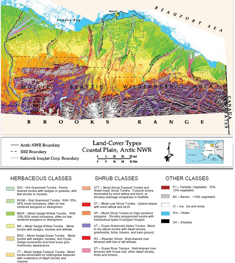
Land Cover and Vegetation Map, Arctic National Wildlife Refuge
National Aeronautics and Space Administration —
This data set provides a landcover map with 16 landcover classes for the northern coastal plain of the the Arctic National Wildlife Refuge (ANWR) on the North Slope... -
Federal
LBA-ECO LC-07 Bathymetric Survey of Floodplain Lake, Lago Curuai, Para, Brazil: 2004
National Aeronautics and Space Administration —
The bathymetry data provided represent a continuous surface of interpolated point measurements of depth values of Lago Curuai, an Amazon River floodplain lake,... -
Federal
BOREAS Site and Area Geographic Coordinate Information
National Aeronautics and Space Administration —
In an effort to properly document the sites and areas where data were collected, personnel of the BOReal Ecosystem-Atmosphere Study (BOREAS) Information System... -
Federal
BOREAS TE-20 Supplementary Site Information For NSA Tower Sites
National Aeronautics and Space Administration —
The BOREAS TE-20 team collected several data sets for use in developing and testing models of forest ecosystem dynamics. This data set and documentation were compiled... -
Federal
LBA-ECO CD-06 Physical, Political, and Hydrologic Maps, Ji-Parana River Basin, Brazil
National Aeronautics and Space Administration —
This data set contains physical, hydrologic, political, demographic, and societal maps for the Ji-Parana River Basin, in the state of Rondonia, Brazil. These data... -
Federal
Arctic Vegetation Plots at Atqasuk, Alaska, 1975, 2000, and 2010
National Aeronautics and Space Administration —
This data set provides vegetation species abundance data collected in 1975 from 60 sites on the Arctic Coastal Plain near Atqasuk, Alaska, as well as environmental... -
Federal
LBA-ECO LC-09 Natural, Infrastructure, and Boundary Features, Amazonian Sites, Brazil
National Aeronautics and Space Administration —
This data set includes 16 zipped archives of shapefiles of cities, rivers and streams, roads, and study area boundaries of several Amazonian study sites: Altamira,...

Official websites use .gov
A
.gov website belongs to an official government
organization in the United States.
Secure .gov websites use HTTPS
A
lock (
) or https:// means you’ve safely connected to
the .gov website. Share sensitive information only on official,
secure websites.