
-
Federal
Global 1-km Gridded Thickness of Soil, Regolith, and Sedimentary Deposit Layers
National Aeronautics and Space Administration —
This data set provides high-resolution estimates of the thickness of the permeable layers above bedrock (soil, regolith, and sedimentary deposits) within a global... -
Federal
LBA-ECO CD-10 H2O Profiles at km 67 Tower Site, Tapajos National Forest
National Aeronautics and Space Administration —
This data set reports vertical profiles of H2O vapor concentrations measured at the Para Western (Santarem) - km 67, Primary Forest Tower Site (Figure 1). This site... -
Federal
A Global Database of Gas Fluxes from Soils after Rewetting or Thawing, Version 1.0
National Aeronautics and Space Administration —
This database contains information compiled from published studies on gas flux from soil following rewetting or thawing. The resulting database includes 222 field and... -
Federal
Leaf Area Index Maps at 30-m Resolution, VALERI Site, Larose, Canada
National Aeronautics and Space Administration —
This data set provide local LAI maps for the Larose (Ontario) site in Canada. These derived maps may also be useful for validating other LAI maps over this same site... -
Federal
Global Maps of Atmospheric Nitrogen Deposition, 1860, 1993, and 2050
National Aeronautics and Space Administration —
This data set provides global gridded estimates of atmospheric deposition of total inorganic nitrogen (N), NHx (NH3 and NH4+), and NOy (all oxidized forms of nitrogen... -
Federal
BOREAS RSS-01 PARABOLA SSA Surface Reflectance and Transmittance Data
National Aeronautics and Space Administration —
The BOREAS RSS-01 team collected surface reflectance and transmittance data from three forested sites in the SSA. This data set contains averaged reflectance factors... -
Federal
BOREAS HYD-03 Snow Temperature Profiles
National Aeronautics and Space Administration —
The BOREAS HYD-03 team collected several data sets related to the hydrology of forested areas. This data set contains measurements of snow depth, snow density in 3-cm... -
Federal
LBA-ECO LC-01 Landsat MSS, TM, ETM+ Imagery, Northern Ecuadorian Amazon: 1973-2002
National Aeronautics and Space Administration —
This data set contains a time series of early Landsat-4 MSS satellite imagery as well as Landsat-5 TM and Landsat-7 ETM+ satellite imagery of the northern Ecuadorian... -
Federal
AMAZE-08 Aerosol Characterization and Meteorological Data, Central Amazon Basin: 2008
National Aeronautics and Space Administration —
This data set provides measurements from the Amazonian Aerosol Characterization Experiment (AMAZE-08) carried out during the wet season from February 4 to March 21,... -
Federal
SAFARI 2000 Wetlands Data Set, 1-Deg (Matthews and Fung)
National Aeronautics and Space Administration —
This database, compiled by Matthews and Fung (1987), provides information on the distribution and environmental characteristics of natural wetlands. The database was... -
Federal
COMEX: AVIRIS-Classic Facility Instrument Associated Flights and Information, 2014
National Aeronautics and Space Administration —
This dataset lists flight lines and provides data access links and contextual flight information for a subset of the AVIRIS-Classic Facility Instrument Collection... -
Federal
LBA-ECO ND-11 Forest Soil Structure and Nitrate, NW Mato Grosso, Brazil: 2004-2005
National Aeronautics and Space Administration —
This data set reports the results of the analysis of soil samples for Nitrate (NO3) and physical properties that were collected for one year following reduced impact... -
Federal
LBA-ECO CD-10 Coarse Woody Debris Data at km 67 Tower Site, Tapajos National Forest
National Aeronautics and Space Administration —
This data sets reports properties of fallen course woody debris in an old-growth upland forest at the Para Western (Santarem) - km 67, Primary Forest Tower Site. This... -
Federal
LBA-ECO LC-15 JERS-1 Synthetic Aperture Radar, 1- km Mosaic, Amazon Basin: 1995-1996
National Aeronautics and Space Administration —
This data set contains two image mosaics of L-band radar backscatter and two image mosaics of first order texture. The two backscatter images are mosaics of L-band... -
Federal
BOREAS RSS-20 POLDER C-130 Measurements of Surface BRDF
National Aeronautics and Space Administration —
This data set contains measurements of surface BRDF made by the POLDER instrument over several surface types (pine, spruce, fen) of the BOREAS SSA during the 1994... -
Federal
MAPSS: Mapped Atmosphere-Plant-Soil System Model, Version 1.0
National Aeronautics and Space Administration —
MAPSS (Mapped Atmosphere-Plant-Soil System) is a landscape to global vegetation distribution model that was developed to simulate the potential biosphere impacts and... -
Federal
ABoVE: Methane Flux across Two Thermokarst Lake Ecosystems, Interior Alaska, 2018
National Aeronautics and Space Administration —
This dataset provides diffusive methane (CH4) fluxes collected from two thermokarst lakes in the Goldstream Valley, north of Fairbanks in interior Alaska. Fluxes were... -
Federal
LBA-ECO LC-14 Modeled Deforestation Scenarios, Amazon Basin: 2002-2050
National Aeronautics and Space Administration —
This data set provides the results of the two modeled scenarios for future patterns of deforestation across the Amazon Basin from 2002 to 2050. This larger defined... -
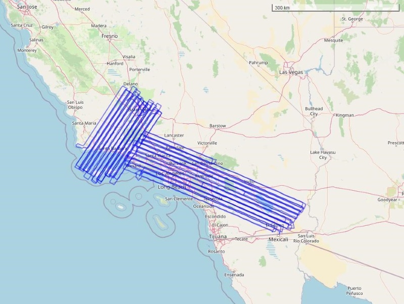
Federal
Sources of Methane Emissions (Vista-LA), South Coast Air Basin, California, USA
National Aeronautics and Space Administration —
This data set provides spatial data products with identified and classified locations of potential methane (CH4) emitting facilities and infrastructure in the South... -
Federal
NPP Grassland: Central Plains Experimental Range (SGS), USA, 1939-1990, R1
National Aeronautics and Space Administration —
This data set records the productivity of a semiarid shortgrass prairie steppe located in the Central Plains Experimental Reserve (CPER)/Pawnee National Grassland in...

Official websites use .gov
A
.gov website belongs to an official government
organization in the United States.
Secure .gov websites use HTTPS
A
lock (
) or https:// means you’ve safely connected to
the .gov website. Share sensitive information only on official,
secure websites.