
-
Federal
A Global Database of Gas Fluxes from Soils after Rewetting or Thawing, Version 1.0
National Aeronautics and Space Administration —
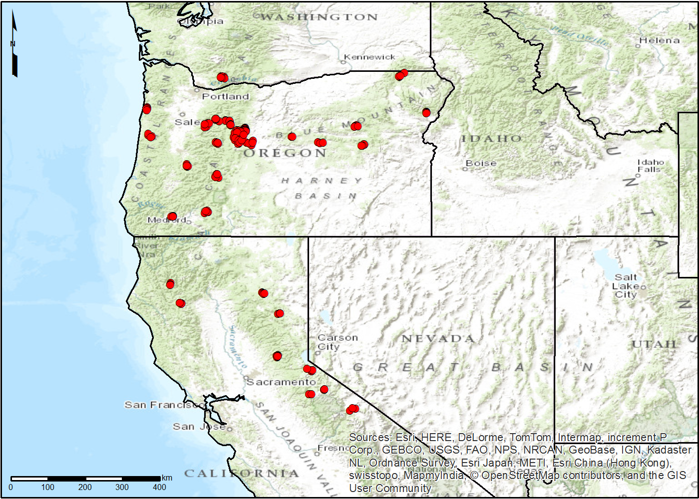
This database contains information compiled from published studies on gas flux from soil following rewetting or thawing. The resulting database includes 222 field and... -
Federal
Global MODIS and FLUXNET-derived Daily Gross Primary Production, V2
National Aeronautics and Space Administration —
This dataset provides global gridded daily estimates of gross primary production (GPP) and uncertainties at 0.05-degree resolution for the period 2000-03-01 to the... -
Federal
Spatial Data Access Tool (SDAT)
National Aeronautics and Space Administration —
The ORNL DAAC Spatial Data Access Tool (SDAT) is a suite of Web-based applications that enable users to visualize and download spatial data in user-selected... -
Federal
Pre-LBA ISLSCP Initiative I Data
National Aeronautics and Space Administration —
This data set contains hydrology, soils, radiation, cloud, and vegetation data from the International Satellite Land Surface Climatology Project (ISLSCP) Initiative... -
Federal
BioSCape Vegetation Surveys Berg and Eerste River Catchments, South Africa, 2022-2023
National Aeronautics and Space Administration —
This dataset contains vegetation plot survey data collected at 36 sites across the Berg and Eerste River catchments in the Western Cape, South Africa collected during... -
Federal
Global 30-Year Mean Monthly Climatology, 1901-1960 (New et al.)
National Aeronautics and Space Administration —
This is a data set of 30-year mean monthly surface climate data over global land areas, excluding Antarctica, for the period 1901-1960. The data set is gridded at 0.5... -
Federal
Gridded GEDI Vegetation Structure Metrics and Biomass Density at Multiple Resolutions
National Aeronautics and Space Administration —
This dataset consists of near-global, analysis-ready, multi-resolution gridded vegetation structure metrics derived from NASA Global Ecosystem Dynamics Investigation... -
Federal
BOREAS HYD-08 Throughfall Data
National Aeronautics and Space Administration —
The BOREAS HYD-08 team made measurements of surface hydrological processes at the SSA (1996) and NSA OBS (1994) Tower Flux sites, supporting its research into point... -
Federal
Annual Land Use and Urban Land Cover: Ethiopia, Nigeria, and South Africa, 2016-2020
National Aeronautics and Space Administration —
This dataset provides a two-tier annual Land Use (LU) and Urban Land Cover (LC) product suite over three African countries, Ethiopia, Nigeria, and South Africa,... -
Federal
NACP TERRA-PNW: Forest Plant Traits, NPP, Biomass, and Soil Properties, 1999-2014
National Aeronautics and Space Administration —
This data set contains measurements and estimates of leaf, tree, and soil data from six projects conducted by the Terrestrial Ecosystem Research and Regional... -
Federal
LBA-ECO LC-23 Vegetation Fire Data, Roraima , Brazil: 2003
National Aeronautics and Space Administration —
The ASTER high resolution satellite data are available for visible-near infrared (15m resolution), short wave infrared (30m), and thermal infrared (90m) bands. Two... -
Federal
LBA-ECO CD-06 Physical, Political, and Hydrologic Maps, Ji-Parana River Basin, Brazil
National Aeronautics and Space Administration —
This data set contains physical, hydrologic, political, demographic, and societal maps for the Ji-Parana River Basin, in the state of Rondonia, Brazil. These data... -
Federal
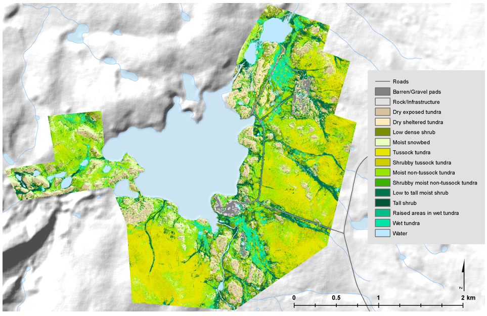
High-Resolution Vegetation Community Maps, Toolik Lake Area, Alaska, 2013-2015
National Aeronautics and Space Administration —
This dataset contains vegetation community maps at 20 cm resolution for three landscapes near the Toolik Lake research area in the northern foothills of the Brooks... -
Federal
MASTER: Wildfire and farmland mapping, California, July, 2004
National Aeronautics and Space Administration —
This dataset includes Level 1B (L1B) and Level 2 (L2) data products from the MODIS/ASTER Airborne Simulator (MASTER) instrument. The spectral data were collected... -
Federal
NPP Multi-Biome: Gridded Estimates for Selected Regions Worldwide, 1954-1998, R3
National Aeronautics and Space Administration —
This data set provides two data files (.csv format) containing gridded (0.5-degree) estimates of net primary productivity (NPP), elevation, temperature,... -
Federal
Forest Aboveground Biomass for Maryland, USA
National Aeronautics and Space Administration —
This dataset includes estimates of annual forest aboveground biomass over the state of Maryland, USA, for the period 1984-2023. It was generated by a modeling... -
Federal
BOREAS HYD-03 SSA/OLD Aspen DBH Data
National Aeronautics and Space Administration —
The BOREAS HYD-03 team collected several data sets related to the hydrology of forested areas. This data set contains measurements of tree diameter at breast height... -
Federal
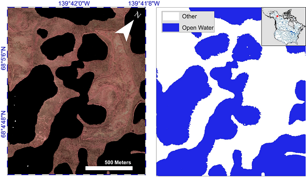
ABoVE: AirSWOT Water Masks from Color-Infrared Imagery over Alaska and Canada, 2017
National Aeronautics and Space Administration —
This dataset provides 1) a conservative open water mask for future water surface elevation (WSE) extraction from the co-registered AirSWOT Ka-band interferometry... -
Federal
BOREAS TGB-08 Monoterpene Concentration Data over the SSA-OBS and the SSA-OJP
National Aeronautics and Space Administration —
The TGB-08 team collected data to investigate the controls over non-methane hydrocarbon (NMHC) fluxes from boreal forest tree species. This data set contains... -
Federal
BOREAS TGB-10 Oxidant Flux Data over the SSA
National Aeronautics and Space Administration —
The BOREAS TGB-10 team collected several trace gas data sets in their efforts to determine the role of biogenic hydrocarbon emissions with respect to boreal forest...

Official websites use .gov
A
.gov website belongs to an official government
organization in the United States.
Secure .gov websites use HTTPS
A
lock (
) or https:// means you’ve safely connected to
the .gov website. Share sensitive information only on official,
secure websites.