
-
Federal
VEMAP 2: Annual Ecosystem Model Responses to U.S. Climate Change, 1994-2100
National Aeronautics and Space Administration —
The Vegetation-Ecosystem Modeling and Analysis Project (VEMAP) was a large, collaborative, multi-institutional, international effort whose goal was to evaluate the... -
Federal
GEDI-FIA Fusion: Training Lidar Models to Estimate Forest Attributes
National Aeronautics and Space Administration —
This dataset includes interpolated cumulative waveforms, with uncertainties, over national forest inventory (FIA) field plots across the contiguous United States. The... -
Federal
NACP Aboveground Biomass and Carbon Baseline Data, V.2 (NBCD 2000), U.S.A., 2000
National Aeronautics and Space Administration —
The NBCD 2000 (National Biomass and Carbon Dataset for the Year 2000) data set provides a high-resolution (30 m) map of year-2000 baseline estimates of basal area-... -
Federal
Leaf Photosynthesis Rates (FIFE)
National Aeronautics and Space Administration —
The objective of the Leaf Photosynthesis study was to measure the response of leaf photosynthesis and stomatal conductance to light, temperature, vapor pressure... -
Federal
Soil Organic Carbon and Wetland Intrinsic Potential, Hoh River Watershed, WA, 2012-13
National Aeronautics and Space Administration —
This dataset contains estimates of soil organic carbon stocks and wetland intrinsic potential (WIP) across the Hoh River Watershed in the Olympic Peninsula, WA, USA... -
Federal
Soil Water Prop. Derived Data (FIFE)
National Aeronautics and Space Administration —
During the 1989 FIFE field campaign, measurements were made of soil moisture release parameters and hydraulic conductivity. Bulk density and soil moisture release... -
Federal
BOREAS/AES MARS-II 15-minute Surface Meteorological Data: 1994
National Aeronautics and Space Administration —
Canadian AES personnel collected several data sets related to surface and atmospheric meteorological conditions over the BOREAS region. This data set contains... -
Federal
BOREAS/SRC AMS Suite A Surface Meteorological and Radiation Data: 1996
National Aeronautics and Space Administration —
The Saskatchewan Research Council (SRC) collected surface meteorological and radiation data from December, 1993 until Decemb er 1996. The data set is comprised of the... -
Federal
BOREAS TGB-08 Monoterpene Concentration Data over the SSA-OBS and the SSA-OJP
National Aeronautics and Space Administration —
The TGB-08 team collected data to investigate the controls over non-methane hydrocarbon (NMHC) fluxes from boreal forest tree species. This data set contains... -
Federal
BOREAS TE-18 Landsat TM Physical Classification Image of the SSA
National Aeronautics and Space Administration —
The objective of this classification is to provide the BOREAS investigators with a data product that characterizes the land cover of the SSA. A Landsat-5 TM image... -
Federal
NPP Multi-Biome: Gridded Estimates for Selected Regions Worldwide, 1954-1998, R3
National Aeronautics and Space Administration —
This data set provides two data files (.csv format) containing gridded (0.5-degree) estimates of net primary productivity (NPP), elevation, temperature,... -
Federal
BOREAS AFM-12 1-km AVHRR Seasonal Land Cover Classification
National Aeronautics and Space Administration —
This regional land cover classification is based on the use of multitemporal 1-km Advanced Very High Resolution Radiometer (AVHRR) National Oceanic and Atmospheric... -
Federal
BOREAS Follow-On DSP-10 Regridded TM Mosaic Land Cover Maps for 1994
National Aeronautics and Space Administration —
Existing 30-m land cover Thematic Mapper classification by CCRS was aggregated and reprocessed and are now available at multiple resolutions (10x5 minutes and 30... -
Federal
BOREAS AES Five-day Averaged Surface Meteorological and Upper Air Data
National Aeronautics and Space Administration —
The Canadian Atmospheric Environment Service (AES) provided BOREAS with hourly and daily surface meteorological data from 23 of the AES meteorological stations... -
Federal
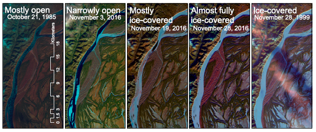
ABoVE: River Ice Breakup and Freeze-up Stages, Yukon River Basin, Alaska, 1972-2016
National Aeronautics and Space Administration —
This dataset provides estimates of river ice breakup and freeze-up stages along selected reaches of the Yukon and Tanana Rivers in the Yukon River Basin in interior... -
Federal
ABoVE: Wetland Type, Slave River and Peace-Athabasca Deltas, Canada, 2007 and 2017
National Aeronautics and Space Administration —
This dataset provides ecosystem-types for the Slave River Delta (SRD) and Peace-Athabasca Delta (PAD), Canada, for the time periods circa 2007 and circa 2017. The... -
Federal
ABoVE: Lake and Pond Extents in Alaskan Boreal and Tundra Subregions, 2019-2021
National Aeronautics and Space Administration —
This dataset provides polygon spatial files of lake and pond extents for three sub-regions of Interior Alaska's boreal forest, and one tundra region located in... -
Federal
LBA-ECO CD-08 Radiocarbon Dating of Tree Ages in Amazonas, Acre, and Para in Brazil
National Aeronautics and Space Administration —
This data set reports the ages and growth rates of trees determined by radiocarbon dating (14C) in three Amazonia forests. Tree samples were collected from permanent... -
Federal
Forest Inventories and DBH at Burned and Unburned Forest Sites, Acre, Brazil, 2017
National Aeronautics and Space Administration —
This data set provides measurements of diameter at breast height (DBH) and species identification at four forest sites in the eastern side of Acre, Brazil including... -
Federal
BOREAS SERM Forest Cover Data Layers of the SSA in Vector Format
National Aeronautics and Space Administration —
The forest cover data provided by Saskatchewan Environment and Resource Management, Forestry Branch - Inventory Unit (SERM-FBIU) are basically a digital version of...

Official websites use .gov
A
.gov website belongs to an official government
organization in the United States.
Secure .gov websites use HTTPS
A
lock (
) or https:// means you’ve safely connected to
the .gov website. Share sensitive information only on official,
secure websites.