
-
Federal
Global Distribution of Root Turnover in Terrestrial Ecosystems
National Aeronautics and Space Administration —
Estimates of root turnover rates were calculated from measurements of live root standing crop and belowground net primary production (BNPP) compiled from the primary... -
Federal
Amazon Forest Structure from Airborne Lidar, ED2 Initial Condition Files, 2016
National Aeronautics and Space Administration —
This dataset provides initial condition files for initializing the Ecosystem Demography Model (ED2). This dataset holds regional forest structure characteristics... -
Federal
Tundra Plant Reflectance, CO2 Exchange, PAM Fluorometry, and Pigments, AK, 2001-2002
National Aeronautics and Space Administration —
This dataset provides measurements at tundra plots collected near Utqiagvik and Atqasuk, AK, including visible-near infrared spectral reflectance, chamber gas... -
Federal
BOREAS Follow-On HMet-04 1996-1998 NSA Meteorological Data
National Aeronautics and Space Administration —
As part of the BOREAS Follow-on, an extended period of data collection was supported in the NSA because of the continued efforts at the NSA-OBS site. This data set... -
Federal
ATom: L2 In Situ Measurements from NOAA Nitrogen Oxides and Ozone (NOyO3) Instrument
National Aeronautics and Space Administration —
This dataset provides in situ concentrations of nitric oxide (NO), nitrogen dioxide (NO2), total reactive nitrogen oxides (NOy), and ozone (O3) measured by the NOAA... -
Federal
GEDI-FIA Fusion: Training Lidar Models to Estimate Forest Attributes
National Aeronautics and Space Administration —
This dataset includes interpolated cumulative waveforms, with uncertainties, over national forest inventory (FIA) field plots across the contiguous United States. The... -
Federal
NACP Aboveground Biomass and Carbon Baseline Data, V.2 (NBCD 2000), U.S.A., 2000
National Aeronautics and Space Administration —
The NBCD 2000 (National Biomass and Carbon Dataset for the Year 2000) data set provides a high-resolution (30 m) map of year-2000 baseline estimates of basal area-... -
Federal
A Global Database of Gas Fluxes from Soils after Rewetting or Thawing, Version 1.0
National Aeronautics and Space Administration —
This database contains information compiled from published studies on gas flux from soil following rewetting or thawing. The resulting database includes 222 field and... -
Federal
Soil Thermal Conductivity Data (FIFE)
National Aeronautics and Space Administration —
The purpose of the 1989 FIFE soil properties investigation was to obtain a description of the thermal properties of the soils within the FIFE study area. Soil thermal... -
Federal
Soil Moisture Profiles and Temperature Data from SoilSCAPE Sites, USA
National Aeronautics and Space Administration —
This data set contains in-situ soil moisture profile and soil temperature data collected at 20-minute intervals at SoilSCAPE (Soil moisture Sensing Controller and... -
Federal
Wind Profile Data: LIDAR - NOAA (FIFE)
National Aeronautics and Space Administration —
The aim of this wind profile study was to derive wind profiles and momentum fluxes from the National Oceanic and Atmospheric Administration (NOAA)/Wave Propagation... -
Federal
NACP New England and Sierra National Forests Biophysical Measurements: 2008-2010
National Aeronautics and Space Administration —
This data set includes biophysical measurements collected in 2009 from five New England experimental forest stations: Bartlett Experimental Forest, Harvard Forest,... -
Federal
Visible and Near-Infrared Leaf Reflectance Spectra, 1992-1993 (ACCP)
National Aeronautics and Space Administration —
The leaf spectra datasets contain visible and near infrared reflectance spectra data for both fresh and dry leaf samples collected in the ACCP. These samples are from... -
Federal
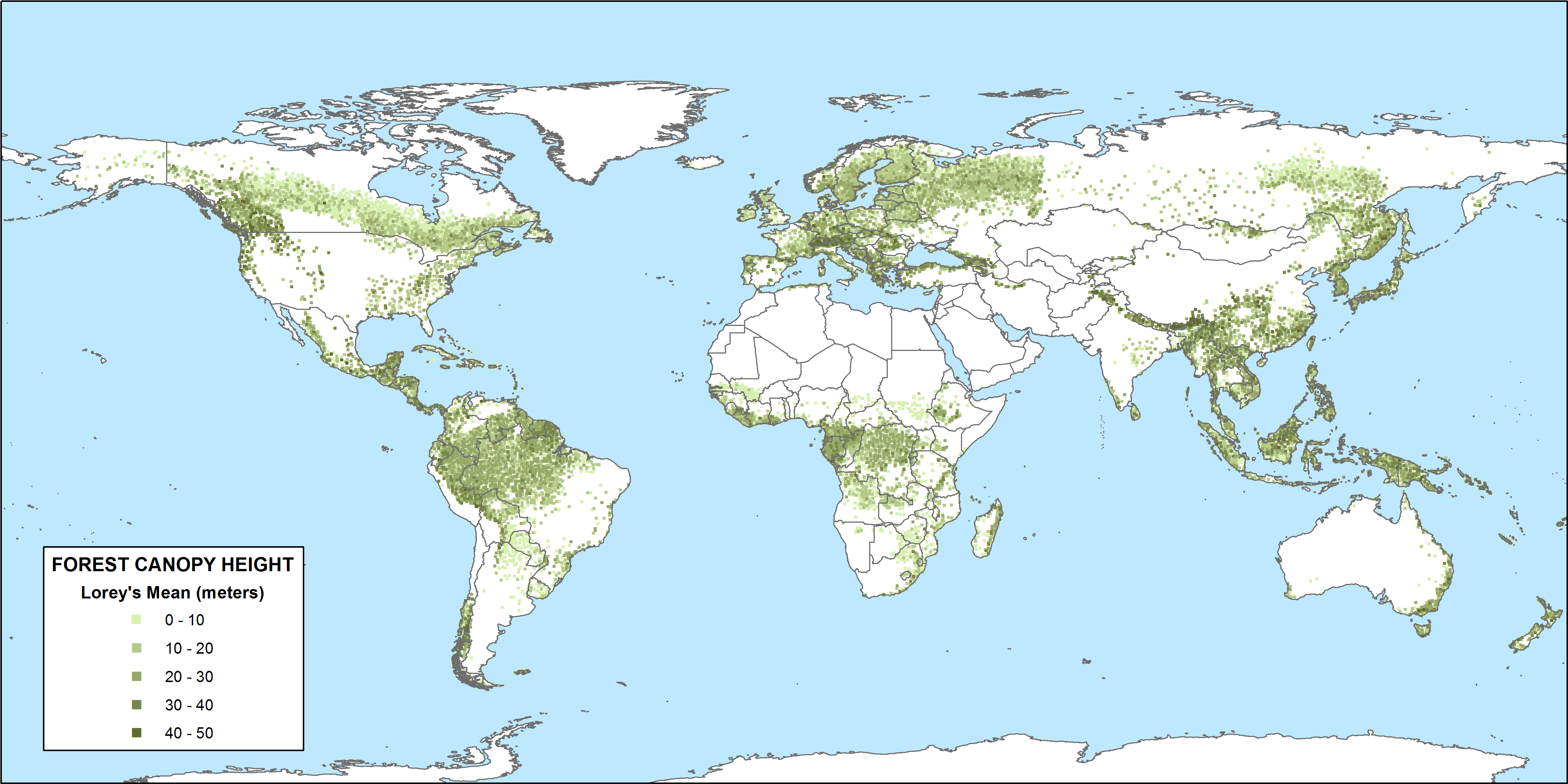
CMS: GLAS LiDAR-derived Global Estimates of Forest Canopy Height, 2004-2008
National Aeronautics and Space Administration —
This data set provides estimates of forest canopy height derived from the Geoscience Laser Altimeter System (GLAS) LiDAR instrument that was aboard the NASA Ice,... -
Federal
Satellite Landsat TM Extr. Data (FIFE)
National Aeronautics and Space Administration —
The Thematic Mapper sensor system was used to collect the original data between February 1987 and October 1989 from which this data set was produced. Landsat TM... -
Federal
SHIFT: Laboratory Foliar Chemical Analysis Results for Field Samples, CA, 2022
National Aeronautics and Space Administration —
This dataset holds laboratory foliar chemical analyses results for field samples collected during the 2022 NASA Surface Biology Geology (SBG) High Frequency Time... -
Federal
Soil Matric Potential, Dielectric, and Physical Properties, Arctic Alaska, 2018
National Aeronautics and Space Administration —
This dataset provides lab-measured soil properties, including soil water matric potential, soil dielectric properties, soil electrical conductivity, corresponding... -
Federal
Reflectance Reference Targets (OTTER)
National Aeronautics and Space Administration —
Spectral reflectance measurements of flat field targets as reference points representative of psuedo-invariant targets as measured by the Spectron SE590... -
Federal
BOREAS/SRC AMS Suite A Surface Meteorological and Radiation Data: 1994
National Aeronautics and Space Administration —
The Saskatchewan Research Council (SRC) collected surface meteorological and radiation data from December, 1993 until Decemb er 1996. The data set is comprised of the...

Official websites use .gov
A
.gov website belongs to an official government
organization in the United States.
Secure .gov websites use HTTPS
A
lock (
) or https:// means you’ve safely connected to
the .gov website. Share sensitive information only on official,
secure websites.