
-
Federal
VEMAP 2: U.S. Daily Climate Change Scenarios
National Aeronautics and Space Administration —
The Vegetation/Ecosystem Modeling and Analysis Project (VEMAP) Phase 2 has developed a number of transient climate change scenarios based on coupled atmosphere-ocean... -
Federal
Global Distribution of Root Turnover in Terrestrial Ecosystems
National Aeronautics and Space Administration —
Estimates of root turnover rates were calculated from measurements of live root standing crop and belowground net primary production (BNPP) compiled from the primary... -
Federal
Amazon Forest Structure from Airborne Lidar, ED2 Initial Condition Files, 2016
National Aeronautics and Space Administration —
This dataset provides initial condition files for initializing the Ecosystem Demography Model (ED2). This dataset holds regional forest structure characteristics... -
Federal
Global Organic Soil Carbon and Nitrogen (Zinke et al.)
National Aeronautics and Space Administration —
This package contains worldwide soil carbon and nitrogen data for more than 3,500 soil profiles. The database was begun about 40 years ago with the collection and... -
Federal
Regridded Harmonized World Soil Database v1.2
National Aeronautics and Space Administration —
This data set describes select global soil parameters from the Harmonized World Soil Database (HWSD) v1.2, including additional calculated parameters such as area... -
Federal
BOREAS Follow-On HMet-04 1996-1998 NSA Meteorological Data
National Aeronautics and Space Administration —
As part of the BOREAS Follow-on, an extended period of data collection was supported in the NSA because of the continued efforts at the NSA-OBS site. This data set... -
Federal
NPP Tropical Forest: Marafunga, Papua New Guinea, 1970-1971, R1
National Aeronautics and Space Administration —
This data set contains two ASCII files (.txt format), one providing net primary production (NPP) component data for a lower montane rainforest and the other providing... -
Federal
Spatio-temporal Characteristics of Rainfall in Africa, 0.25 degrees, from 1998-2012
National Aeronautics and Space Administration —
This data set describes rainfall distribution statistics over the African continent, including Madagascar. The rainfall estimates are based on data from the NASA... -
Federal
LBA-ECO LC-08 Soil, Vegetation, and Land Cover Maps for Brazil and South America
National Aeronautics and Space Administration —
This data set provides (1) soil maps for Brazil that are digital versions of the MAPA DE SOLOS DO BRASIL (EMBRAPA, 1981) classified at three levels of detail,... -
Federal
Forest Inventory and Biophysical Measurements, Brazilian Amazon, 2009-2018
National Aeronautics and Space Administration —
This dataset provides the complete catalog of forest inventory and biophysical measurements collected over selected forest research sites across the Amazon rainforest... -
Federal
NACP Aboveground Biomass and Carbon Baseline Data, V.2 (NBCD 2000), U.S.A., 2000
National Aeronautics and Space Administration —
The NBCD 2000 (National Biomass and Carbon Dataset for the Year 2000) data set provides a high-resolution (30 m) map of year-2000 baseline estimates of basal area-... -
Federal
NACP North American 8-km Net Ecosystem Exchange and Component Fluxes, 2004
National Aeronautics and Space Administration —
This data set provides modeled carbon flux estimates at 8-km spatial resolution over North America for the year 2004 of (1) net ecosystem exchange (NEE) of carbon... -
Federal
Wind Profile Data: LIDAR - NOAA (FIFE)
National Aeronautics and Space Administration —
The aim of this wind profile study was to derive wind profiles and momentum fluxes from the National Oceanic and Atmospheric Administration (NOAA)/Wave Propagation... -
Federal
NACP New England and Sierra National Forests Biophysical Measurements: 2008-2010
National Aeronautics and Space Administration —
This data set includes biophysical measurements collected in 2009 from five New England experimental forest stations: Bartlett Experimental Forest, Harvard Forest,... -
Federal
Visible and Near-Infrared Leaf Reflectance Spectra, 1992-1993 (ACCP)
National Aeronautics and Space Administration —
The leaf spectra datasets contain visible and near infrared reflectance spectra data for both fresh and dry leaf samples collected in the ACCP. These samples are from... -
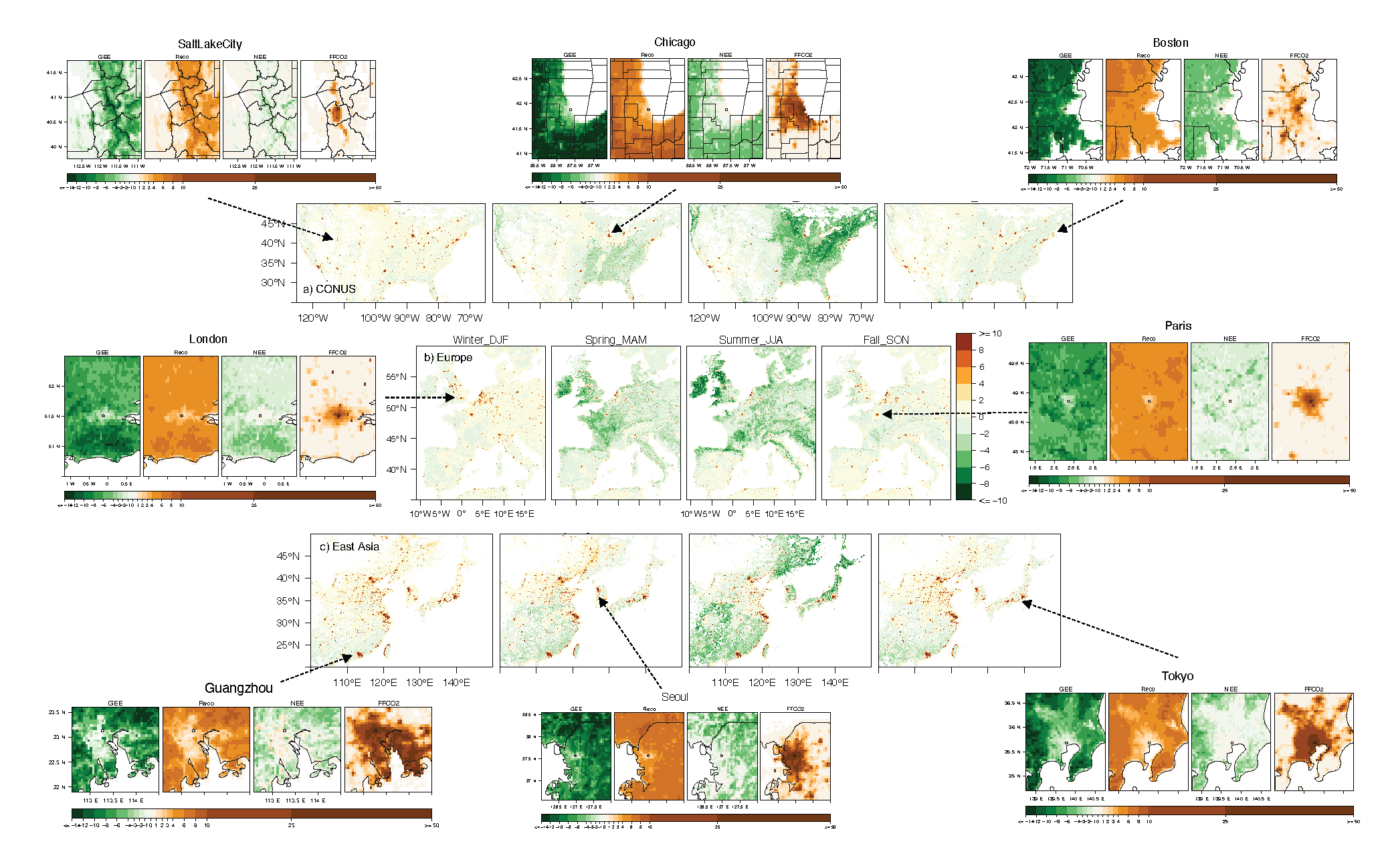
Federal
Urban Biogenic CO2 fluxes: GPP, Reco and NEE Estimates from SMUrF, 2010-2019
National Aeronautics and Space Administration —
This dataset contains estimates of biogenic CO2 flux components at 0.05 degree resolution from the Solar-Induced Fluorescence (SIF) for Modeling Urban biogenic Fluxes... -
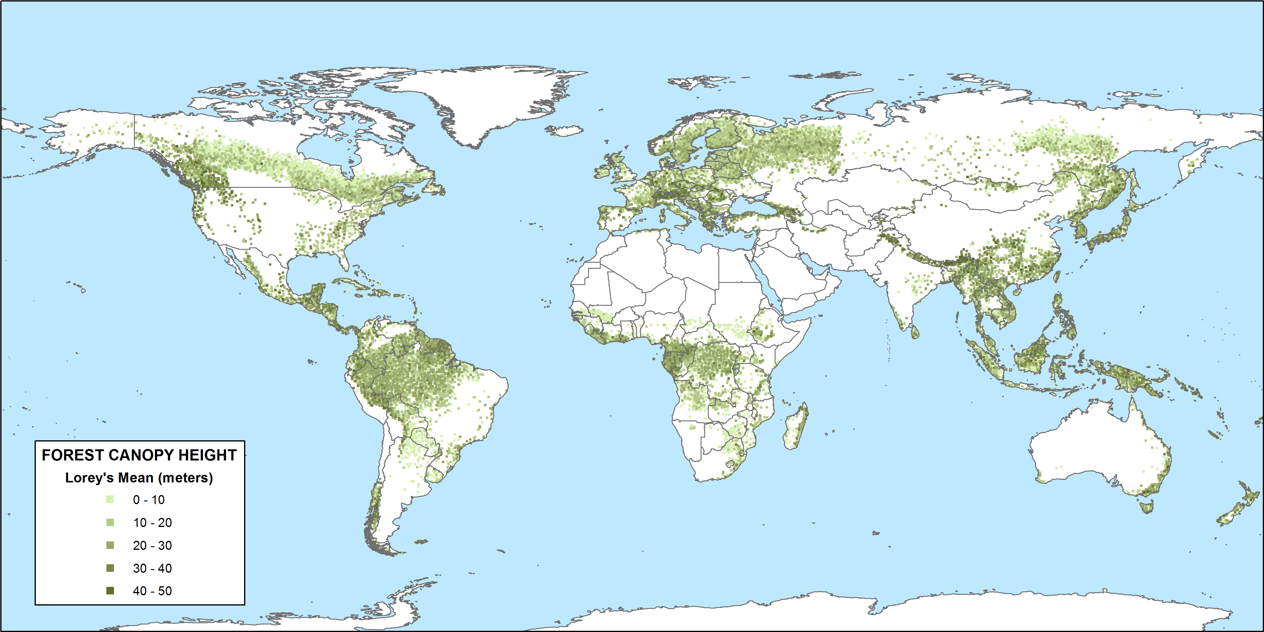
Federal
CMS: GLAS LiDAR-derived Global Estimates of Forest Canopy Height, 2004-2008
National Aeronautics and Space Administration —
This data set provides estimates of forest canopy height derived from the Geoscience Laser Altimeter System (GLAS) LiDAR instrument that was aboard the NASA Ice,... -
Federal
Satellite Landsat TM Extr. Data (FIFE)
National Aeronautics and Space Administration —
The Thematic Mapper sensor system was used to collect the original data between February 1987 and October 1989 from which this data set was produced. Landsat TM... -
Federal
Soil Water Prop. Derived Data (FIFE)
National Aeronautics and Space Administration —
During the 1989 FIFE field campaign, measurements were made of soil moisture release parameters and hydraulic conductivity. Bulk density and soil moisture release...

Official websites use .gov
A
.gov website belongs to an official government
organization in the United States.
Secure .gov websites use HTTPS
A
lock (
) or https:// means you’ve safely connected to
the .gov website. Share sensitive information only on official,
secure websites.