
-
Federal
Global Vegetation Greenness (NDVI) from AVHRR GIMMS-3G+, 1981-2022
National Aeronautics and Space Administration —
This dataset holds the Global Inventory Modeling and Mapping Studies-3rd Generation V1.2 (GIMMS-3G+) data for the Normalized Difference Vegetation Index (NDVI). NDVI... -
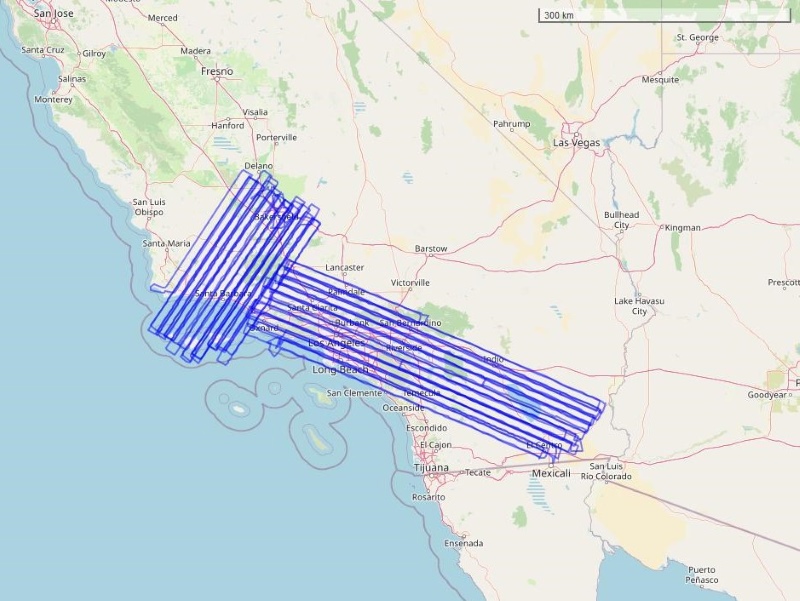
Federal
MASTER: Airborne Science, California-Nevada, May-June, 2008
National Aeronautics and Space Administration —
This dataset includes Level 1B (L1B) and Level 2 (L2) data products from the MODIS/ASTER Airborne Simulator (MASTER) instrument. The spectral data were collected as... -
Federal
MODIS-derived Aggregate, Woody and Herbaceous Leaf Area Index for Africa, 2002-2022
National Aeronautics and Space Administration —
This dataset provides leaf area index (LAI) estimates for Sub-Saharan Africa for woody, herbaceous, and aggregate vegetation types. The estimates were derived from... -
Federal
MASTER: Geological Earth Mapping Experiment (GEMx), Spring 2024
National Aeronautics and Space Administration —
This dataset includes Level 1B (L1B) data products from the MODIS/ASTER Airborne Simulator (MASTER) instrument. The spectral data were collected during 26 flights... -
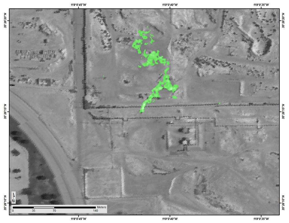
Federal
Longwave-infrared spectral imagery in support of COMEX, 2014
National Aeronautics and Space Administration —
This dataset provides calibrated at-sensor radiance, retrieved surface brightness temperature, and adaptive coherence estimator (ACE) detection imagery of methane,... -
Federal
SAFARI 2000 Digital Elevation Model, 1-km (GLOBE)
National Aeronautics and Space Administration —
This data set consists of a southern African subset of the Global Land One-Kilometer Base Elevation (GLOBE) digital elevation model (DEM) data in both ASCII GRID and... -
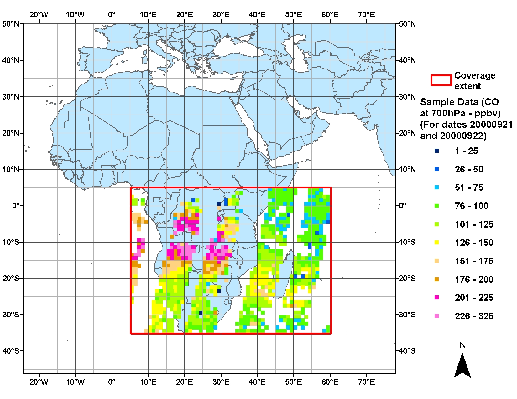
Federal
SAFARI 2000 MOPITT Tropospheric Carbon Monoxide, Southern Africa, Dry Season 2000
National Aeronautics and Space Administration —
The MOPITT (Measurements Of Pollution In The Troposphere) instrument on the NASA Terra Satellite makes measurements of infrared radiation originating from the surface... -
Federal
SAFARI 2000 Estimated BVOC Emissions for Southern African Land Cover Types
National Aeronautics and Space Administration —
Improved vegetation distribution and emission data for Africa south of the equator were developed for the Southern African Regional Science Initiative (SAFARI 2000)... -
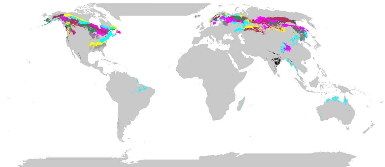
Federal
Phenoregions For Monitoring Vegetation Responses to Climate Change
National Aeronautics and Space Administration —
The overall purpose in this research was to identify the regions of the world best suited for long-term monitoring of biospheric responses to climate change, i.e.... -
Federal
COMEX: AVIRIS-Classic Facility Instrument Associated Flights and Information, 2014
National Aeronautics and Space Administration —
This dataset lists flight lines and provides data access links and contextual flight information for a subset of the AVIRIS-Classic Facility Instrument Collection... -
Federal
CMS: Global 0.5-deg Wetland Methane Emissions and Uncertainty (WetCHARTs v1.3.3)
National Aeronautics and Space Administration —
This dataset provides global monthly wetland methane (CH4) emissions estimates at 0.5 by 0.5-degree resolution for the period 2001-01-01 to 2022-08-31 that were... -
Federal
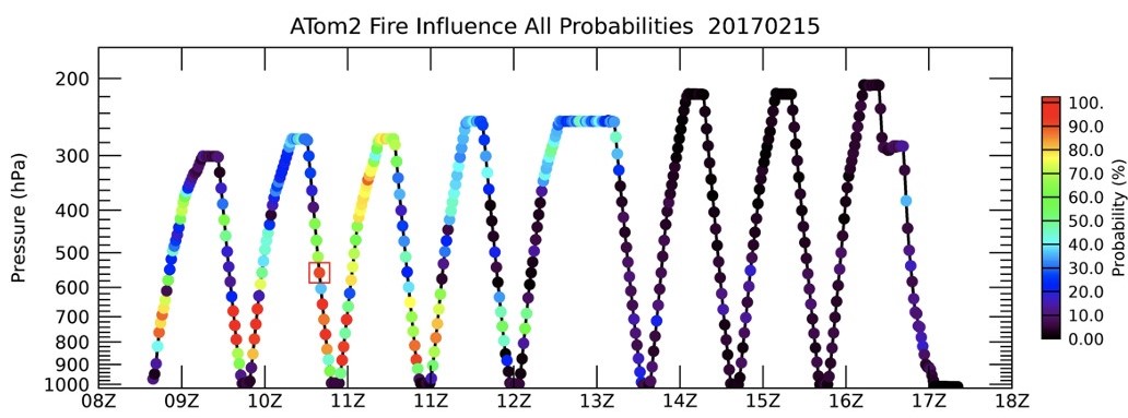
ATom: Back Trajectories and Influences of Air Parcels Along Flight Track, 2016-2018
National Aeronautics and Space Administration —
This dataset contains back trajectories, boundary layer influences, and convective influences of air parcels along NASA DC-8 aircraft's flight tracks during the four... -
Federal
Annual Land Use and Urban Land Cover: Ethiopia, Nigeria, and South Africa, 2016-2020
National Aeronautics and Space Administration —
This dataset provides a two-tier annual Land Use (LU) and Urban Land Cover (LC) product suite over three African countries, Ethiopia, Nigeria, and South Africa,... -
Federal
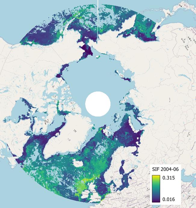
Monthly SIF Estimates from TROPOMI over the Arctic Ocean, 2004-2020
National Aeronautics and Space Administration —
This dataset provides solar-induced chlorophyll fluorescence (SIF) estimates over the Arctic Ocean at a 0.05-degree resolution for each month from January 2004... -
Federal
Methane Emissions from Dairy Sources (Vista-CA), State of California, USA, 2019
National Aeronautics and Space Administration —
This dataset provides estimates of methane (CH4) emissions from dairies in California at a resolution of 0.1 degrees (~ 10 km x 10 km) for the year 2019. The mapped... -
Federal
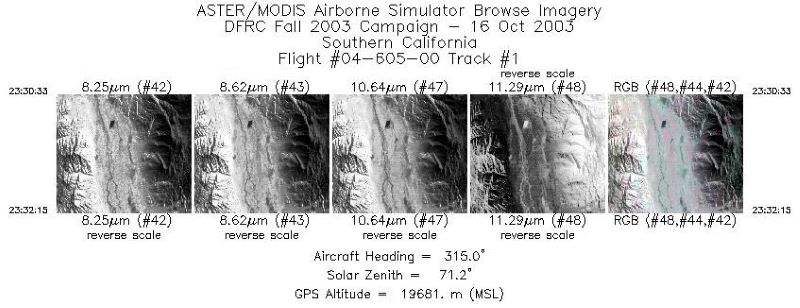
MASTER: Airborne Science, Western US, October, 2003
National Aeronautics and Space Administration —
This dataset includes Level 1B (L1B) and Level 2 (L2) data products from the MODIS/ASTER Airborne Simulator (MASTER) instrument. The spectral data were collected... -
Federal
MASTER: Student Airborne Research Program (SARP) campaign, California, USA, 2016
National Aeronautics and Space Administration —
This dataset includes Level 1B (L1B) data products from the MODIS/ASTER Airborne Simulator (MASTER) instrument collected and developed by the Student Airborne... -
Federal
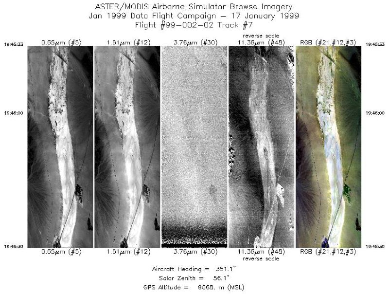
MASTER: Instrument validation, California-Nevada, December, 1998
National Aeronautics and Space Administration —
This dataset includes Level 1B (L1B) data products from the MODIS/ASTER Airborne Simulator (MASTER) instrument. The spectral data were collected during a single...

Official websites use .gov
A
.gov website belongs to an official government
organization in the United States.
Secure .gov websites use HTTPS
A
lock (
) or https:// means you’ve safely connected to
the .gov website. Share sensitive information only on official,
secure websites.