
-
Federal
VEMAP 2: Annual Ecosystem Model Responses to U.S. Climate Change, 1994-2100
National Aeronautics and Space Administration —
The Vegetation-Ecosystem Modeling and Analysis Project (VEMAP) was a large, collaborative, multi-institutional, international effort whose goal was to evaluate the... -
Federal
BOREAS TGB-04 Water and Sediment Temperature Data over the NSA-BP (Beaver Pond)
National Aeronautics and Space Administration —
The BOREAS TGB-04 team collected several data sets in support of their flux tower measurements at the NSA Beaver Pond site. This data set contains water and sediment... -
Federal
CARVE: CH4, CO2, and CO Atmospheric Concentrations, CARVE Tower, Alaska, 2012-2014
National Aeronautics and Space Administration —
This data set provides hourly atmospheric concentrations of methane (CH4), carbon dioxide (CO2), and carbon monoxide (CO) as mole fractions, from January 2012 to... -
Federal
BioSCape: BioSoundSCape Acoustic Recordings, South Africa, 2023
National Aeronautics and Space Administration —
This dataset holds in situ sound recordings from sites in Greater Cape Floristic Region (GCFR), South Africa from June to December 2023. The recordings were collected... -
Federal
LBA-ECO LC-08 Soil, Vegetation, and Land Cover Maps for Brazil and South America
National Aeronautics and Space Administration —
This data set provides (1) soil maps for Brazil that are digital versions of the MAPA DE SOLOS DO BRASIL (EMBRAPA, 1981) classified at three levels of detail,... -
Federal
BioSCape Vegetation Surveys Berg and Eerste River Catchments, South Africa, 2022-2023
National Aeronautics and Space Administration —
This dataset contains vegetation plot survey data collected at 36 sites across the Berg and Eerste River catchments in the Western Cape, South Africa collected during... -
Federal
NACP Aboveground Biomass and Carbon Baseline Data, V.2 (NBCD 2000), U.S.A., 2000
National Aeronautics and Space Administration —
The NBCD 2000 (National Biomass and Carbon Dataset for the Year 2000) data set provides a high-resolution (30 m) map of year-2000 baseline estimates of basal area-... -
Federal
Spatial Data Access Tool (SDAT)
National Aeronautics and Space Administration —
The ORNL DAAC Spatial Data Access Tool (SDAT) is a suite of Web-based applications that enable users to visualize and download spatial data in user-selected... -
Federal
NACP North American 8-km Net Ecosystem Exchange and Component Fluxes, 2004
National Aeronautics and Space Administration —
This data set provides modeled carbon flux estimates at 8-km spatial resolution over North America for the year 2004 of (1) net ecosystem exchange (NEE) of carbon... -
Federal
PnET Models: Carbon, Nitrogen, Water Dynamics in Forest Ecosystems (Vers. 4 and 5)
National Aeronautics and Space Administration —
PnET (Photosynthetic / EvapoTranspiration model) is a nested series of models of carbon, water, and nitrogen dynamics in forest ecosystems. The models can be used to... -
Federal
VEMAP 1: U.S. Potential Natural Vegetation
National Aeronautics and Space Administration —
The Vegetation/Ecosystem Modeling and Analysis Project (VEMAP) is an ongoing multiinstitutional, international effort addressing the response of biogeography and... -
Federal
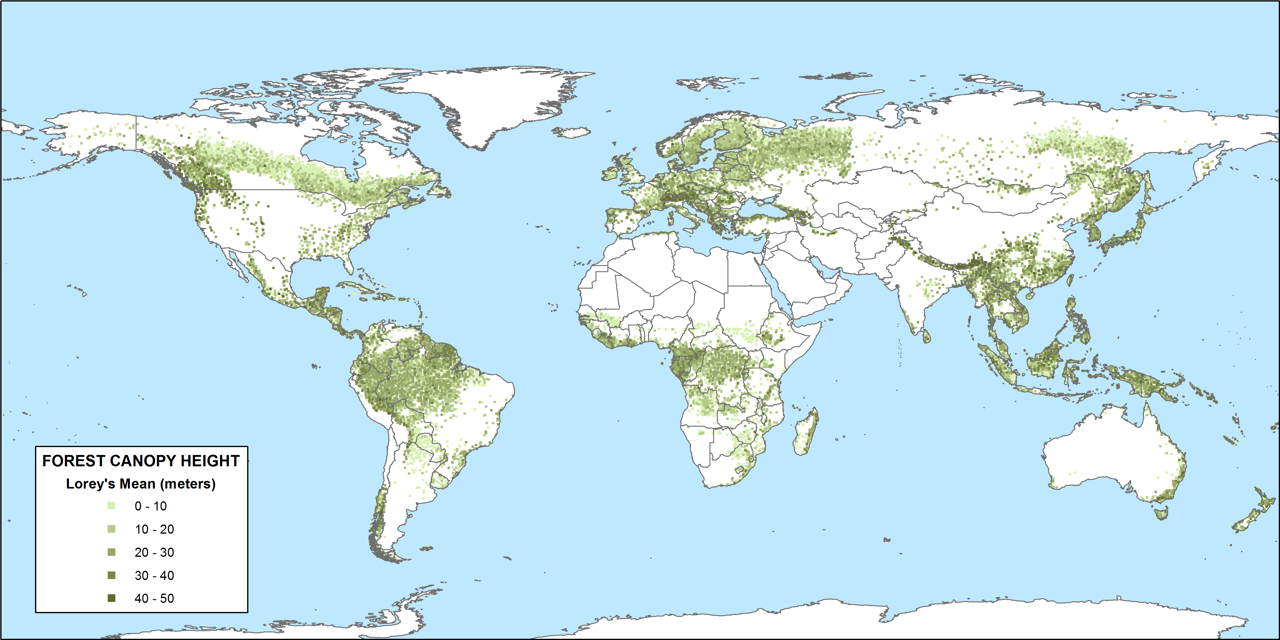
CMS: GLAS LiDAR-derived Global Estimates of Forest Canopy Height, 2004-2008
National Aeronautics and Space Administration —
This data set provides estimates of forest canopy height derived from the Geoscience Laser Altimeter System (GLAS) LiDAR instrument that was aboard the NASA Ice,... -
Federal
COMEX: Flight Information for AJAX Airborne In Situ CO2 and CH4, 2014-2015, USA
National Aeronautics and Space Administration —
This dataset provides information to access NASA Earthdata published flight data and flight information collected by the Alpha Jet Atmospheric eXperiment (AJAX) and... -
Federal
SHIFT: Laboratory Foliar Chemical Analysis Results for Field Samples, CA, 2022
National Aeronautics and Space Administration —
This dataset holds laboratory foliar chemical analyses results for field samples collected during the 2022 NASA Surface Biology Geology (SBG) High Frequency Time... -
Federal
Soil CO2 Flux Data (FIFE)
National Aeronautics and Space Administration —
In the Soil Carbon Dioxide Flux study, a prototype gas exchange system and sensor were used to determine the soil surface flux of CO2 and associated parameters at the... -
Federal
BOREAS/SRC AMS Suite A Surface Meteorological and Radiation Data: 1996
National Aeronautics and Space Administration —
The Saskatchewan Research Council (SRC) collected surface meteorological and radiation data from December, 1993 until Decemb er 1996. The data set is comprised of the... -
Federal
BOREAS TGB-10 Oxidant Flux Data over the SSA
National Aeronautics and Space Administration —
The BOREAS TGB-10 team collected several trace gas data sets in their efforts to determine the role of biogenic hydrocarbon emissions with respect to boreal forest... -
Federal
SAFARI 2000 Emissions Estimates, MODIS Burned Area Product, Dry Season 2000
National Aeronautics and Space Administration —
The recently generated MODIS burned area product over southern Africa for the month of September 2000 was used to calculate regional biomass burning emissions from... -
Federal
BOREAS TGB-03 CH4 and CO2 Chamber Flux Data over NSA Upland Sites
National Aeronautics and Space Administration —
The BOREAS TGB-03 team collected methane and carbon dioxide (CH4, CO2) chamber flux measurements at the NSA Fen site, OBS, YJP, and auxiliary sites along Gillam Road...

Official websites use .gov
A
.gov website belongs to an official government
organization in the United States.
Secure .gov websites use HTTPS
A
lock (
) or https:// means you’ve safely connected to
the .gov website. Share sensitive information only on official,
secure websites.